Login
Register


PVE
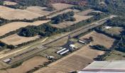
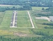
Beech River Regional Airport
Official FAA Data Effective 2026-02-19 0901Z
Chart Supplement

VFR Chart of KPVE
Sectional Charts at SkyVector.com
IFR Chart of KPVE
Enroute Charts at SkyVector.com
Location Information for KPVE
Coordinates: N35°39.38' / W88°11.72'Located 05 miles NW of Lexington-Parsons, Tennessee on 467 acres of land. View all Airports in Tennessee.
Surveyed Elevation is 487 feet MSL.
Operations Data
|
|
Airport Communications
| AWOS-3: | 118.125 Tel. 731-845-5738 |
|---|---|
| CTAF: | 123.000 |
| UNICOM: | 123.000 |
| AWOS-3 at SNH (29.0 S): | 133.925 731-925-6080 |
| AWOS-3 at HZD (29.1 NW): | 133.275 731-352-2854 |
| AWOS-3 at SZY (31.0 SW): | 118.425 731-645-8184 |
- APCH/DEP SVC PRVDD BY MEMPHIS ARTCC ON FREQS 125.85/379.25 (CENTERVILLE RCAG).
Nearby Navigation Aids
|
| ||||||||||||||||||||||||||||||||||||||||||||||||||||||||||||


Runway 01/19
| Dimensions: | 6000 x 100 feet / 1829 x 30 meters | |
|---|---|---|
| Surface: | Concrete in Good Condition | |
| Weight Limits: | 38 /R/C/W/T, S-99, D-130 | |
| Edge Lighting: | Medium Intensity | |
| Runway 01 | Runway 19 | |
| Coordinates: | N35°38.90' / W88°11.85' | N35°39.87' / W88°11.60' |
| Elevation: | 445.7 | 487.7 |
| Runway Heading: | 12° True | 192° True |
| Markings: | Non-Precision Instrument in good condition. | Non-Precision Instrument in good condition. |
| Glide Slope Indicator | P2L (3.09° Glide Path Angle) | P2L (3.29° Glide Path Angle) |
| REIL: | Yes | Yes |
Services Available
| Fuel: | 100LL (blue), Jet A+ |
|---|---|
| Transient Storage: | Hangars,Tiedowns |
| Airframe Repair: | MAJOR |
| Engine Repair: | MAJOR |
| Bottled Oxygen: | NOT AVAILABLE |
| Bulk Oxygen: | NOT AVAILABLE |
| Other Services: | PILOT INSTRUCTION |
Ownership Information
| Ownership: | Publicly owned | |
|---|---|---|
| Owner: | BEECH RIVER REGIONAL ARPT AUTHORITY | |
| 1600 MT ARARAT ROAD | ||
| DARDEN, TN 38328 | ||
| 731-845-5740 | ||
| Manager: | KEITH COTTON | |
| 1600 MT ARARAT ROAD | ||
| DARDEN, TN 32328 | ||
| 731-845-4937 | ||
Other Remarks
- FOR CD CTC MEMPHIS ARTCC AT 901-368-8453/8449.
- AFT HR SVC - AMGR.
- 0LL H24 CREDIT CARD SVC AVBL.
- ACTVT REIL RWY 01 & 19; MIRL RWY 01/19 - CTAF. PAPI RWY 01 & 19 OPR CONSLY.
Weather Minimums

Instrument Approach Procedure (IAP) Charts
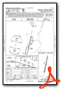

Nearby Airports with Instrument Procedures
| ID | Name | Heading / Distance | ||
|---|---|---|---|---|
 |
0M4 | Benton County Airport | 009° | 21.4 |
|
KHZD | Sgt Lee Russell Carroll County Airport | 333° | 29.0 |
|
KSNH | Savannah-Hardin County Airport | 182° | 29.1 |
|
0M3 | Paul Bridges Field Airport | 102° | 30.0 |
|
KSZY | Robert Sibley Airport | 208° | 31.0 |
|
M53 | Humboldt Municipal Airport | 284° | 34.3 |
|
KMKL | Jackson Regional Airport | 264° | 35.4 |
|
0M5 | Humphreys County Airport | 038° | 35.5 |
|
KTGC | Gibson County Airport | 297° | 35.9 |
|
KGHM | Centerville Municipal Airport | 073° | 38.2 |
|
KPHT | Henry County Airport | 347° | 41.7 |
|
M02 | Dickson Municipal Airport | 052° | 46.8 |