Login
Register


PIL
Cameron County Airport
Official FAA Data Effective 2026-02-19 0901Z
Chart Supplement

VFR Chart of KPIL
Sectional Charts at SkyVector.com
IFR Chart of KPIL
Enroute Charts at SkyVector.com
Location Information for KPIL
Coordinates: N26°9.97' / W97°20.75'Located 10 miles NW of Port Isabel, Texas on 826 acres of land. View all Airports in Texas.
Surveyed Elevation is 18 feet MSL.
Operations Data
|
|
Airport Communications
| ASOS: | 118.525 Tel. 956-233-1954 |
|---|---|
| VALLEY APPROACH: | 119.5 257.6 |
| VALLEY DEPARTURE: | 119.5 257.6 |
| CLEARANCE DELIVERY: | 119.2 |
| UNICOM: | 122.800 |
| CTAF: | 122.800 |
| ASOS at BRO (15.9 S): | 128.55 956-299-5871 |
| ATIS at BRO (16.2 S): | 128.55 |
| ATIS at HRL (17.1 W): | 124.85 |
Nearby Navigation Aids
|
| ||||||||||||||||||||||||||||||||||||||||||||||||


Runway 13/31
| Dimensions: | 8001 x 200 feet / 2439 x 61 meters | |
|---|---|---|
| Surface: | Asphalt-Concrete in Good Condition | |
| Weight Limits: | S-105, D-135, ST-230 | |
| Edge Lighting: | Medium Intensity | |
| Runway 13 | Runway 31 | |
| Coordinates: | N26°10.38' / W97°20.99' | N26°9.45' / W97°19.95' |
| Elevation: | 13.9 | 18.4 |
| Traffic Pattern: | Left | Left |
| Runway Heading: | 135° True | 315° True |
| Markings: | Non-Precision Instrument in good condition. | Non-Precision Instrument in good condition. |
| Glide Slope Indicator | P2L (2.00° Glide Path Angle) | P2L (3.00° Glide Path Angle) |
| REIL: | Yes REIL OTS. | Yes REIL OTS. |
Runway 08/26
| Dimensions: | 5317 x 150 feet / 1621 x 46 meters | |
|---|---|---|
| Surface: | Concrete in Poor Condition ROUGH PAVEMENT. RWY HAS HEAVY GRASS ENCROACHMENT. | |
| Weight Limits: | S-50, D-60, ST-110 | |
| Runway 08 | Runway 26 | |
| Coordinates: | N26°9.82' / W97°21.25' | N26°9.82' / W97°20.28' |
| Elevation: | 12.6 | 16.9 |
| Traffic Pattern: | Left | Left |
| Runway Heading: | 90° True | 270° True |
| Markings: | Numbers Only in fair condition. | Numbers Only in fair condition. |
| Obstacles: | 8 ft Fence 330 ft from runway, 261 ft left of center | 20 ft Trees 254 ft from runway, 250 ft right of center |
Runway 03/21
| Dimensions: | 5000 x 150 feet / 1524 x 46 meters | |
|---|---|---|
| Surface: | Asphalt-Concrete in Poor Condition RWY PAVEMENT HAS HEAVY GRASS ENCROACHMENT. | |
| Weight Limits: | S-30, D-45, ST-90 | |
| Runway 03 | Runway 21 | |
| Coordinates: | N26°9.72' / W97°21.30' | N26°10.39' / W97°20.78' |
| Elevation: | 12.8 | 11.6 |
| Traffic Pattern: | Left | Left |
| Runway Heading: | 35° True | 215° True |
| Markings: | Numbers Only in poor condition. | Numbers Only in poor condition. |
| Obstacles: | 12 ft Brush 630 ft from runway | 12 ft Tree 480 ft from runway, 240 ft left of center |
Runway 17/35
| Dimensions: | 4200 x 75 feet / 1280 x 23 meters | |
|---|---|---|
| Surface: | Asphalt-Concrete in Good Condition | |
| Weight Limits: | S-30, D-45, ST-90 | |
| Runway 17 | Runway 35 | |
| Coordinates: | N26°10.52' / W97°20.94' | N26°9.83' / W97°20.93' |
| Elevation: | 12.6 | 16.0 |
| Traffic Pattern: | Left | Left |
| Runway Heading: | 180° True | 360° True |
| Markings: | Basic in good condition. | Basic in good condition. |
| Obstacles: | 273 ft Tower 4000 ft from runway, 605 ft left of center | |
Services Available
| Fuel: | 100LL (blue), Jet-A |
|---|---|
| Transient Storage: | Hangars,Tiedowns |
| Airframe Repair: | MINOR |
| Engine Repair: | MINOR |
| Bottled Oxygen: | NOT AVAILABLE |
| Bulk Oxygen: | LOW |
Ownership Information
| Ownership: | Publicly owned | |
|---|---|---|
| Owner: | CAMERON COUNTY | |
| COUNTY COURTHOUSE, 1100 E. MONROE | ||
| BROWNSVILLE, TX 78520 | ||
| 956-544-0830 | ||
| Manager: | JOE VEGA | |
| 33174 STATE PARK RD 100 SOUTH | ||
| SOUTH PADRE ISLAND, TX 78597 | ||
| 956-761-3700 | JEVEGA@CO.CAMERON.TX.US | |
Other Remarks
- NO POSITION HOLDING MARKINGS ON NUMEROUS TWYS APPROACHING RY INTERSECTIONS.
- LOOSE GRAVEL/PAVEMENT AT INTERSECTION OF RY 13 & NORTHEAST TWY CONNECTING RYS 13 & 21.
- FOR CD CTC CORPUS CHRISTI APCH AT 361-299-4230.
- MARKINGS FADED
- MARKINGS FADED.
- MARKINGS FADED.
- MARKINGS FADED.
- 0LL 100 LL & JET A AVBL SELF SERVE & FULL SERV.
Weather Minimums


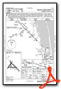
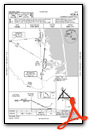
Instrument Approach Procedure (IAP) Charts
Nearby Airports with Instrument Procedures
| ID | Name | Heading / Distance | ||
|---|---|---|---|---|
 |
KBRO | Brownsville/South Padre Island International Airport | 195° | 16.1 |
|
KHRL | Valley International Airport | 282° | 17.1 |
|
KTXW | Mid Valley Airport | 271° | 33.9 |
|
KEBG | South Texas International At Edinburg Airport | 291° | 45.0 |
|
KMFE | Mc Allen International Airport | 270° | 48.2 |
|
KBKS | Brooks County Airport | 326° | 74.9 |
|
KNQI | Kingsville NAS Airport | 342° | 83.8 |
|
KIKG | Kleberg County Airport | 336° | 90.6 |
|
KNGP | Corpus Christi NAS (Truax Field) Airport | 001° | 91.4 |
|
KCRP | Corpus Christi International Airport | 355° | 96.5 |
|
KRBO | Nueces County Airport | 349° | 98.2 |
|
KRAS | Mustang Beach Airport | 007° | 99.4 |
Airport Images
Do you have a recent image of this airport? Upload it here!


