Login
Register


UZA
Rock Hill/York County/Bryant Field Airport
Official FAA Data Effective 2025-12-25 0901Z
Chart Supplement

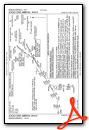
VFR Chart of KUZA
Sectional Charts at SkyVector.com
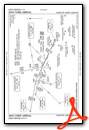
IFR Chart of KUZA
Enroute Charts at SkyVector.com
Location Information for KUZA
Coordinates: N34°59.27' / W81°3.43'Located 04 miles NW of Rock Hill, South Carolina on 490 acres of land. View all Airports in South Carolina.
Surveyed Elevation is 666 feet MSL.
Operations Data
|
|
Airport Communications
| ASOS: | 120.775 Tel. 803-981-9388 |
|---|---|
| CHARLOTTE APPROACH: | 120.05 307.8 |
| CHARLOTTE DEPARTURE: | 120.05 307.8 |
| ESTRR DP: | 120.05 307.8 |
| BEAVY DP: | 120.05 307.8 |
| BARMY DP: | 120.05 307.8 |
| WEAZL DP: | 120.05 307.8 |
| KNIGHTS DP: | 120.05 307.8 |
| ICONS DP: | 120.05 307.8 |
| CTAF: | 123.050 |
| BOBZY DP: | 120.05 307.8 |
| JOOLS STAR: | 135.6 377.15 |
| KWEEN DP: | 120.05 307.8 |
| RASLN STAR: | 126.15 282.325 |
| KILNS DP: | 120.05 307.8 |
| KRITR DP: | 120.05 307.8 |
| KERMIT DP: | 120.05 307.8 |
| JOJJO DP: | 120.05 307.8 |
| LILLS DP: | 120.05 307.8 |
| UNICOM: | 123.050 |
| ASOS at AKH (13.4 N): | 135.725 704-868-9034 |
| AWOS-3 at DCM (13.7 SW): | 120.975 803-385-2011 |
| D-ATIS at CLT (14.5 N): | 121.15 ;ARR |
Nearby Navigation Aids
|
| ||||||||||||||||||||||||||||||||||||||||||||||||||||||||||||


Runway 02/20
| Dimensions: | 5500 x 100 feet / 1676 x 30 meters | |
|---|---|---|
| Surface: | Asphalt / Grooved in Good Condition | |
| Weight Limits: | 30 /F/C/X/T, S-78, D-104 | |
| Edge Lighting: | Medium Intensity | |
| Runway 02 | Runway 20 | |
| Coordinates: | N34°58.82' / W81°3.54' | N34°59.71' / W81°3.32' |
| Elevation: | 666.3 | 661.0 |
| Traffic Pattern: | Left | Left |
| Runway Heading: | 11° True | 191° True |
| Markings: | Precision Instrument in good condition. | Precision Instrument in good condition. |
| Glide Slope Indicator | P2L (3.00° Glide Path Angle) | P2L (3.00° Glide Path Angle) |
| Approach Lights: | MALSR 1,400 Foot Medium-intensity Approach Lighting System with runway alignment indicator lights. | |
| Obstacles: | 82 ft Tree 1589 ft from runway, 725 ft left of center | 87 ft Tree 1825 ft from runway, 523 ft left of center |
Services Available
| Fuel: | 100LL (blue), Jet-A |
|---|---|
| Transient Storage: | Hangars,Tiedowns |
| Airframe Repair: | MAJOR |
| Engine Repair: | MAJOR |
| Bottled Oxygen: | HIGH |
| Bulk Oxygen: | NONE |
| Other Services: | AIR FREIGHT SERVICES,AIR AMBULANCE SERVICES,CHARTER SERVICE,PILOT INSTRUCTION,AIRCRAFT RENTAL,AIRCRAFT SALES,ANNUAL SURVEYING |
Ownership Information
| Ownership: | Publicly owned | |
|---|---|---|
| Owner: | CITY OF ROCK HILL | |
| BOX 11706 | ||
| ROCK HILL, SC 29731 | ||
| 803-329-7010 | ||
| Manager: | STEVEN A. GOULD JR., C.M. | FBO - SKYTECH, AARON COPE 803-366-5108. |
| 550 AIRPORT RD, SUITE 205 | ||
| ROCK HILL, SC 29732 | ||
| 803-329-5560 | ||
Other Remarks
- WILDLIFE INVOF ARPT.
- VOLUNTARY NOISE ABATEMENT PROC IN EFCT.
- FOR CD IF UNA TO CTC ON FSS FREQ, CTC CHARLOTTE APCH AT 704-359-0241.
- GCO AVBL ON FREQ 121.725 TO CHARLOTTE APCH.
- DUSK-2300. MIRL RWY 02/20 & MALSR RWY 02 PRESET MED INTST DUSK-2300; TO INCR INTST & ACTVT AFTER 2300 - CTAF.
Weather Minimums
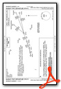
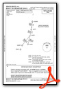
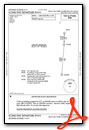
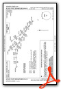
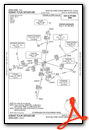
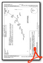
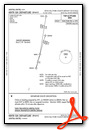
Standard Terminal Arrival (STAR) Charts

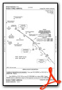
Instrument Approach Procedure (IAP) Charts
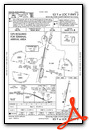
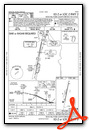

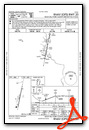
Departure Procedure (DP) Charts


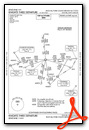

Nearby Airports with Instrument Procedures
| ID | Name | Heading / Distance | ||
|---|---|---|---|---|
 |
KAKH | Gastonia Municipal Airport | 340° | 13.7 |
|
KDCM | Chester Catawba Regional Airport | 209° | 13.7 |
|
KCLT | Charlotte/Douglas International Airport | 021° | 14.5 |
|
N52 | Jaars-Townsend Airport | 115° | 17.0 |
|
KLKR | Lancaster County-Mc Whirter Field Airport | 147° | 18.8 |
|
KEQY | Charlotte/Monroe Exec Airport | 085° | 21.5 |
|
KJQF | Concord-Padgett Regional Airport | 035° | 29.4 |
|
KIPJ | Lincoln County Regional Airport | 350° | 30.1 |
|
KEHO | Shelby-Cleveland County Regional Airport | 301° | 31.2 |
|
35A | Union County, Troy Shelton Field Airport | 238° | 34.0 |
|
KPYG | Pageland Airport | 112° | 38.1 |
|
14A | Lake Norman Airpark Airport | 011° | 38.3 |
Airport Images

By: Big Orange Bird


