Login
Register


TIX
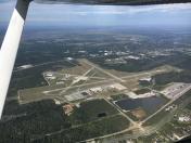
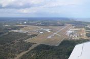
Space Coast Regional Airport
Official FAA Data Effective 2025-12-25 0901Z
Chart Supplement

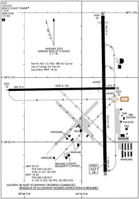
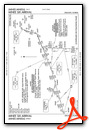
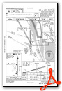
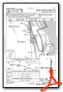
KTIX Airport Diagram
VFR Chart of KTIX
Sectional Charts at SkyVector.com
IFR Chart of KTIX
Enroute Charts at SkyVector.com
Location Information for KTIX
Coordinates: N28°30.89' / W80°47.95'Located 05 miles S of Titusville, Florida on 1650 acres of land. View all Airports in Florida.
Surveyed Elevation is 34 feet MSL.
Operations Data
|
|
Airport Communications
| ATIS: | 120.625 |
|---|---|
| AWOS-3PT: | 120.625 Tel. 321-567-6090 |
| SPACE COAST TOWER: | 118.9 |
| SPACE COAST GROUND: | 121.85 |
| ORLANDO APPROACH: | 134.95 281.425 |
| ORLANDO DEPARTURE: | 134.95 281.425 |
| CTAF: | 118.900 |
| UNICOM: | 122.950 |
| MINEE STAR: | 134.05 339.8 |
| EMERG: | 121.5 243.0 |
| BITHO STAR: | 128.375 338.2 |
| AWOS-3PT at X21 (6.6 N): | 119.725 321-385-0383 |
| AWOS-3PT at COI (12.0 SE): | 119.025 321-986-8864 |
| ASOS at XMR (12.6 E): | 119.325 |
Nearby Navigation Aids
|
| ||||||||||||||||||||||||||||||||||||||||||


Runway 18/36
RWY 18/36 NOT AVBL FOR PART 121/PART 380 OPS WITH SKED PAX CARRYING OPS MORE THAN 9 PAX SEATS AND NON-SKED PAX CARRYING OPS MORE THAN 30 PAX SEATS. | ||
| Dimensions: | 7319 x 150 feet / 2231 x 46 meters | |
|---|---|---|
| Surface: | Asphalt / Grooved in Fair Condition | |
| Weight Limits: | S-120, D-232, ST-395, DT-924
PCR VALUE: 580/F/B/X/T
| |
| Edge Lighting: | High Intensity | |
| Runway 18 | Runway 36 | |
| Coordinates: | N28°31.48' / W80°47.81' | N28°30.27' / W80°47.79' |
| Elevation: | 29.6 | 33.6 |
| Traffic Pattern: | Left | Left |
| Runway Heading: | 179° True | 359° True |
| Displaced Threshold: | 322 Feet | |
| Declared Distances: | TORA:7319 TODA:7319 ASDA:7249 LDA:6930 | TORA:7319 TODA:7319 ASDA:7244 LDA:7244 |
| Markings: | Non-Precision Instrument in fair condition. | Precision Instrument in fair condition. |
| Glide Slope Indicator | P4L (3.00° Glide Path Angle) | P4L (3.00° Glide Path Angle) |
| Approach Lights: | MALSR 1,400 Foot Medium-intensity Approach Lighting System with runway alignment indicator lights. | |
| REIL: | Yes | |
| Obstacles: | 52 ft Trees 1465 ft from runway, 45 ft left of center TREES 425 FT LEFT & RIGHT OF CNTRLN FIRST 1500 FT OF RWY 18. |
24 ft Trees 1155 ft from runway, 365 ft left of center |
Runway 09/27
| Dimensions: | 5000 x 100 feet / 1524 x 30 meters | |
|---|---|---|
| Surface: | Asphalt in Excellent Condition | |
| Weight Limits: | S-96, D-167, ST-305
PCR VALUE: 350/F/A/X/T
| |
| Edge Lighting: | Medium Intensity | |
| Runway 09 | Runway 27 | |
| Coordinates: | N28°30.90' / W80°48.64' | N28°30.92' / W80°47.71' |
| Elevation: | 32.5 | 32.0 |
| Traffic Pattern: | Left | Left |
| Runway Heading: | 89° True | 269° True |
| Declared Distances: | TORA:5000 TODA:5000 ASDA:5000 LDA:5000 | TORA:5000 TODA:5000 ASDA:5000 LDA:5000 |
| Markings: | Non-Precision Instrument in fair condition. | Non-Precision Instrument in fair condition. |
| Glide Slope Indicator | P4L (3.00° Glide Path Angle) | P4L (3.00° Glide Path Angle) |
| REIL: | Yes | Yes |
| Obstacles: | 29 ft Trees 1215 ft from runway, 240 ft left of center | 53 ft Trees 1260 ft from runway, 265 ft left of center |
Services Available
| Fuel: | 100LL (blue), Jet-A |
|---|---|
| Transient Storage: | Hangars,Tiedowns |
| Airframe Repair: | MAJOR |
| Engine Repair: | MAJOR |
| Bottled Oxygen: | NONE |
| Bulk Oxygen: | NONE |
| Other Services: | AVIONICS,CHARTER SERVICE,PILOT INSTRUCTION,AIRCRAFT RENTAL,AIRCRAFT SALES |
Ownership Information
| Ownership: | Publicly owned | |
|---|---|---|
| Owner: | TITUSVILLE COCOA ARPT AUTH | |
| 51 BRISTOW WAY | ||
| TITUSVILLE, FL 32780 | ||
| 321-267-8780 | ||
| Manager: | KEVIN DAUGHERTY, AAE | |
| 51 BRISTOW WAY | ||
| TITUSVILLE, FL 32780 | ||
| 321-267-8780 | ||
Other Remarks
- IN MINIMUM VIS CONDS BRIGHT LGTS IN PARKING LOT 1/4 MILE E OF RY 18 MAY BE MISTAKEN FOR RY LGTS.
- ATCT UNABLE AIR TRAFFIC SVCS ON THESE AREAS OF NON-VISIBILITY: SOUTHWEST PORTIONS OF TAXILANES 'D' AND 'E'.
- FOR CD OR TO CNL IFR IF UNA TO CTC ON FSS FREQ, CTC ORLANDO APCH AT 407-852-7500.
- 0LL FOR FUEL AFT HRS CALL 321-267-8355
- WHEN ATCT CLSD ACTVT MALSR RWY 36; REIL RWYS 9, 18, & 27; PAPI RWYS 09, 27, 18, & 36; MIRL RWY 09/27; HIRL RWY 18/36 - CTAF.
Weather Minimums
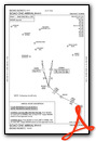
Standard Terminal Arrival (STAR) Charts
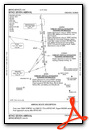
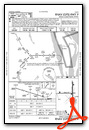
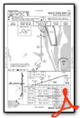
Instrument Approach Procedure (IAP) Charts

Nearby Airports with Instrument Procedures
| ID | Name | Heading / Distance | ||
|---|---|---|---|---|
 |
X21 | Arthur Dunn Air Park Airport | 343° | 6.7 |
|
KTTS | Space Florida Launch and Landing Facility Airport | 042° | 8.2 |
|
KCOI | Merritt Island Airport | 149° | 12.0 |
|
KXMR | Cape Canaveral Space Force Station Skid Strip Airport | 102° | 12.6 |
|
KCOF | Patrick Space Force Base Airport | 149° | 19.5 |
|
KMLB | Melbourne Orlando International Airport | 161° | 26.0 |
|
KMCO | Orlando International Airport | 259° | 27.4 |
|
KSFB | Orlando Sanford International Airport | 304° | 27.8 |
|
KORL | Orlando Exec Airport | 273° | 28.3 |
|
X50 | Massey Ranch Airpark Airport | 346° | 28.6 |
|
KEVB | New Smyrna Beach Municipal (Jack Bolt Field) Airport | 346° | 33.3 |
|
X59 | Valkaria Airport | 158° | 35.5 |