Login
Register


F00
Jones Field Airport
Official FAA Data Effective 2026-01-22 0901Z
Chart Supplement

VFR Chart of F00
Sectional Charts at SkyVector.com
IFR Chart of F00
Enroute Charts at SkyVector.com
Location Information for F00
Coordinates: N33°36.79' / W96°10.76'Located 02 miles N of Bonham, Texas on 300 acres of land. View all Airports in Texas.
Surveyed Elevation is 618 feet MSL.
Operations Data
|
|
Airport Communications
| AWOS-3PT: | 118.05 Tel. 903-583-2082 |
|---|---|
| UNICOM: | 122.800 |
| CTAF: | 122.800 |
| AWOS-3 at DUA (22.5 NW): | 124.175 580-931-3790 |
| AWOS-3PT at GYI (25.4 W): | 118.775 903-786-7790 |
| ATIS at GYI (25.5 W): | 118.775 |
- APCH/DEP SVC PRVDD BY FORT WORTH ARTCC (ZFW) ON FREQS 124.875/370.95 (BONHAM RCAG).
Nearby Navigation Aids
|
| ||||||||||||||||||||||||||||||||||||||||||||||||||||||||||||


Runway 17/35
| Dimensions: | 4000 x 75 feet / 1219 x 23 meters | |
|---|---|---|
| Surface: | Asphalt in Excellent Condition | |
| Weight Limits: | S-12 | |
| Edge Lighting: | Medium Intensity | |
| Runway 17 | Runway 35 | |
| Coordinates: | N33°37.11' / W96°10.75' | N33°36.46' / W96°10.77' |
| Elevation: | 617.9 | 612.3 |
| Traffic Pattern: | Left | Left |
| Runway Heading: | 182° True | 2° True |
| Markings: | Non-Precision Instrument in good condition. | Non-Precision Instrument in good condition. |
| Glide Slope Indicator | P2L (3.00° Glide Path Angle) | P2L (3.00° Glide Path Angle) |
| Obstacles: | 22 ft Trees 540 ft from runway, 260 ft right of center ALSO 43 FT PLINE, 1315 FT DSTC, 225 L/R, 25:1. |
18 ft Antenna 425 ft from runway, 175 ft left of center 33 FT TREES, 0-50 FT DSTC, 239 FT L; 4 FT FENCE, 0-100 FT DSTC, 190 FT L. |
Services Available
| Fuel: | 100LL (blue), Jet A+ |
|---|---|
| Transient Storage: | Tiedowns |
| Airframe Repair: | MAJOR FOR AIRFRAME REPAIRS CALL 903-640-0233 OR 903-583-5119. |
| Engine Repair: | MAJOR |
| Bottled Oxygen: | NONE |
| Bulk Oxygen: | NONE |
| Other Services: | CROP DUSTING SERVICES |
Ownership Information
| Ownership: | Publicly owned | |
|---|---|---|
| Owner: | CITY OF BONHAM | |
| 514 CHESTNUT | ||
| BONHAM, TX 75418 | ||
| 903-583-7555 | ||
| Manager: | ZACK WHITLOCK | DIRECTOR OF PUBLIC WORKS. |
| 514 CHESTNUT | ||
| BONHAM, TX 75418 | ||
| 903-583-8623 | ||
Other Remarks
- FOR CD CTC FORT WORTH ARTCC AT 817-858-7584.
- EXTSV AERIAL AG OPS APR-AUG. OTR TIMES IREG.
- 0LL 100 LL SELF-SERV.
- JET A FULL SERV. CALL 903-227-5199.
- MIRL RWY 17 & 35 SS-SR PRESET LOW; TO ACTVT OR INCR INTST - CTAF. PAPI RWY 17 & PAPI RWY 35 OPR CONSLY.
- UNICOM UNMONITORED.
Weather Minimums

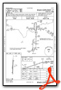
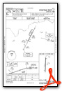
Instrument Approach Procedure (IAP) Charts

Nearby Airports with Instrument Procedures
| ID | Name | Heading / Distance | ||
|---|---|---|---|---|
 |
KSWI | Sherman Municipal Airport | 271° | 20.4 |
|
KDUA | Durant Regional/Eaker Field Airport | 331° | 22.3 |
|
2F7 | Commerce Municipal Airport | 143° | 23.9 |
|
KGYI | North Texas Regional/Perrin Field Airport | 283° | 25.5 |
|
KGVT | Majors Airport | 170° | 33.2 |
|
KTKI | Mckinney Ntl Airport | 218° | 33.2 |
|
7F3 | Caddo Mills Municipal Airport | 185° | 34.7 |
|
KPRX | Cox Field Airport | 087° | 36.5 |
|
KSLR | Sulphur Springs Municipal Airport | 133° | 39.0 |
|
KHHW | Stan Stamper Municipal Airport | 051° | 40.6 |
|
F46 | Ralph M Hall/Rockwall Municipal Airport | 197° | 42.9 |
|
80F | Antlers Municipal Airport | 037° | 43.7 |
Airport Images

By: uwm1kl


