Login
Register


PRX
Cox Field Airport
Official FAA Data Effective 2026-01-22 0901Z
Chart Supplement

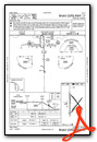
KPRX Airport Diagram

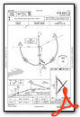
VFR Chart of KPRX
Sectional Charts at SkyVector.com
IFR Chart of KPRX
Enroute Charts at SkyVector.com
Location Information for KPRX
Coordinates: N33°38.20' / W95°27.04'Located 06 miles E of Paris, Texas on 1537 acres of land. View all Airports in Texas.
Surveyed Elevation is 547 feet MSL.
Operations Data
|
|
Airport Communications
| AWOS-3PT: | 119.675 Tel. 903-737-8784 |
|---|---|
| CTAF: | 122.975 |
| UNICOM: | 122.975 |
| AWOS-3 at HHW (24.1 N): | 119.025 580-326-2134 |
| AWOS-3 at SLR (29.9 S): | 118.35 903-885-9605 |
| AWOS-3 at 4O4 (34.1 NE): | 120.0 580-286-2217 |
- APCH/DEP SVC PRVDD BY FORT WORTH ARTCC (ZFW) ON FREQS 124.875/370.95 (BONHAM RCAG).
Nearby Navigation Aids
|
| ||||||||||||||||||||||||||||||||||||||||||||||||||||||||||||


Runway 17/35
| Dimensions: | 6002 x 100 feet / 1829 x 30 meters | |
|---|---|---|
| Surface: | Asphalt in Good Condition | |
| Weight Limits: | S-30 | |
| Edge Lighting: | Medium Intensity | |
| Runway 17 | Runway 35 | |
| Coordinates: | N33°38.69' / W95°27.27' | N33°37.70' / W95°27.25' |
| Elevation: | 541.0 | 526.3 |
| Traffic Pattern: | Left | Left |
| Runway Heading: | 179° True | 359° True |
| Declared Distances: | TORA:6002 TODA:6002 ASDA:6002 LDA:6002 | TORA:6002 TODA:6002 ASDA:6002 LDA:6002 |
| Markings: | Non-Precision Instrument in good condition. | Non-Precision Instrument in good condition. |
| Glide Slope Indicator | P4L (3.00° Glide Path Angle) | P4L (3.00° Glide Path Angle) |
| Obstacles: | 39 FT TREES, 100 FT DSTC, 390 FT L. |
37 ft Trees 325 ft from runway, 260 ft left of center 20 FT TREES, 0-199 FT DSTC, 250 L. |
Runway 03/21
| Dimensions: | 4624 x 150 feet / 1409 x 46 meters | |
|---|---|---|
| Surface: | Concrete in Poor Condition RWY COND NOT MNTND. VEGETATION GROWING THROUGH CRACKS. | |
| Weight Limits: | S-26 | |
| Runway 03 | Runway 21 | |
| Coordinates: | N33°37.82' / W95°27.18' | N33°38.42' / W95°26.63' |
| Elevation: | 530.3 | 546.2 |
| Traffic Pattern: | Left | Left |
| Runway Heading: | 37° True | 217° True |
| Declared Distances: | TORA:4624 TODA:4624 ASDA:4624 LDA:4624 | TORA:4624 TODA:4624 ASDA:4624 LDA:4624 |
| Markings: | Basic in poor condition. | Basic in poor condition. |
| Obstacles: | 28 ft Trees 860 ft from runway, 185 ft left of center | 18 ft Trees 407 ft from runway, 135 ft right of center 40 FT TREES 132 FT DSTC, 245 FT L |
Runway 14/32
| Dimensions: | 4624 x 150 feet / 1409 x 46 meters | |
|---|---|---|
| Surface: | Concrete in Fair Condition | |
| Weight Limits: | S-26 | |
| Runway 14 | Runway 32 | |
| Coordinates: | N33°38.57' / W95°27.19' | N33°37.98' / W95°26.62' |
| Elevation: | 539.5 | 547.3 |
| Traffic Pattern: | Left | Left |
| Runway Heading: | 141° True | 321° True |
| Declared Distances: | TORA:4624 TODA:4624 ASDA:4624 LDA:4624 | TORA:4624 TODA:4624 ASDA:4624 LDA:4624 |
| Markings: | Basic in fair condition. | Basic in fair condition. |
| Obstacles: | 30 ft Trees 455 ft from runway, 245 ft left of center 10 FT BRUSH, 30 FT DSTC, 244 FT L. |
|
Helipad H1
| Dimensions: | 40 x 40 feet / 12 x 12 meters | |
|---|---|---|
| Surface: | Concrete in Good Condition | |
| Coordinates: | N33°38.07' / W95°27.39' | N0°0.00' / E0°0.00' |
| Elevation: | 547.6 | |
| Markings: | None in fair condition. | |
Services Available
| Fuel: | 100LL (blue), Jet-A |
|---|---|
| Transient Storage: | Tiedowns |
| Airframe Repair: | MINOR |
| Engine Repair: | MINOR |
| Bottled Oxygen: | NONE |
| Bulk Oxygen: | NONE |
| Other Services: | CROP DUSTING SERVICES,PILOT INSTRUCTION,AIRCRAFT RENTAL |
Ownership Information
| Ownership: | Publicly owned | |
|---|---|---|
| Owner: | CITY OF PARIS | |
| BOX 9037 | ||
| PARIS, TX 75461 | ||
| 903-784-4648 | ||
| Manager: | THOMAS HERNDON | |
| 6780 COLLIER DR | ||
| PARIS, TX 75462 | ||
| 903-784-4648 | THERNDON@PARISTEXAS.GOV | |
Other Remarks
- THIS AIRPORT HAS BEEN SURVEYED BY THE NATIONAL GEODETIC SURVEY.
- RWYS 03/21 & 14/32 NOT AVBL FOR ACR OPNS WITH MORE THAN 30 PSGR SEATS.
- TWY LGTS FROM TRML APRON TO RWY 17/35 ON MIDFIELD TWY ONLY.
- RWY 14/32 NO LINE OF SIGHT BTN RWY ENDS.
- FOR CD IF UNA TO CTC ON FSS FREQ, CTC FORT WORTH ARTCC AT 817-858-7584.
- MKGS FADED.
- MKGS FADED.
- 0LL 100LL AVBL 24 HR SELF SERVE. FOR JET AFTR HRS, CALL 903-784-4648.
- MIRL RWY 17/35 PRESET LOW INTST DUSK-DAWN; TO INCR INTST ACTVT - CTAF. PAPI RWYS 17 & 35 OPRS CONSLY.
Weather Minimums

Instrument Approach Procedure (IAP) Charts

Nearby Airports with Instrument Procedures
| ID | Name | Heading / Distance | ||
|---|---|---|---|---|
 |
KHHW | Stan Stamper Municipal Airport | 349° | 24.2 |
|
F53 | Franklin County Airport | 156° | 27.4 |
|
KSLR | Sulphur Springs Municipal Airport | 196° | 29.8 |
|
2F7 | Commerce Municipal Airport | 227° | 30.4 |
|
4O4 | Mc Curtain County Regional Airport | 060° | 33.8 |
|
80F | Antlers Municipal Airport | 343° | 34.8 |
|
F00 | Jones Field Airport | 267° | 36.5 |
|
KOSA | Mount Pleasant Regional Airport | 142° | 40.6 |
|
F51 | Winnsboro Municipal Airport | 168° | 42.7 |
|
KGVT | Majors Airport | 222° | 46.0 |
|
KDUA | Durant Regional/Eaker Field Airport | 291° | 50.6 |
|
7F3 | Caddo Mills Municipal Airport | 228° | 53.7 |
Airport Images

By: uwm1kl


