Login
Register


SZT
Sandpoint Airport
Official FAA Data Effective 2026-02-19 0901Z
Chart Supplement

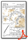
VFR Chart of KSZT
Sectional Charts at SkyVector.com
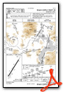
IFR Chart of KSZT
Enroute Charts at SkyVector.com
Location Information for KSZT
Coordinates: N48°17.97' / W116°33.61'Located 02 miles N of Sandpoint, Idaho on 104 acres of land. View all Airports in Idaho.
Surveyed Elevation is 2131 feet MSL.
Operations Data
|
|
Airport Communications
| AWOS-2: | 135.425 Tel. 208-263-3074 |
|---|---|
| UNICOM: | 122.700 |
| CTAF: | 122.700 |
| AWOS-3PT at 65S (27.7 NE): | 132.575 208-267-3995 |
| AWOS-3PT at COE (33.2 S): | 135.075 208-772-8215 |
| ASOS at DEW (39.9 SW): | 135.175 509-276-2303 |
- APCH/DEP CTL SVC PRVDD BY SEATTLE ARTCC (ZSE) ON FREQS 123.95/290.55 (LAKESIDE RCAG.)
Nearby Navigation Aids
|
| ||||||||||||||||||||||||||||||||||||||||||||||||


Runway 02/20
| Dimensions: | 5501 x 75 feet / 1677 x 23 meters | |
|---|---|---|
| Surface: | Asphalt in Good Condition | |
| Weight Limits: | S-40 | |
| Edge Lighting: | Medium Intensity | |
| Runway 02 | Runway 20 | |
| Coordinates: | N48°17.59' / W116°33.97' | N48°18.36' / W116°33.25' |
| Elevation: | 2128.3 | 2128.9 |
| Traffic Pattern: | Left | Left |
| Runway Heading: | 32° True | 212° True |
| Markings: | Non-Precision Instrument in good condition. | Non-Precision Instrument in good condition. |
| Glide Slope Indicator | P2L (3.75° Glide Path Angle) | P2L (3.75° Glide Path Angle) |
| REIL: | Yes | Yes |
| Obstacles: | 60 ft Trees 850 ft from runway, 100 ft right of center | 90 ft Trees 610 ft from runway, 280 ft right of center |
Services Available
| Fuel: | 100LL (blue), Jet-A |
|---|---|
| Transient Storage: | Hangars,Tiedowns |
| Airframe Repair: | MAJOR |
| Engine Repair: | MAJOR |
| Bottled Oxygen: | HIGH/LOW |
| Bulk Oxygen: | NONE |
| Other Services: | CHARTER SERVICE,PILOT INSTRUCTION,AIRCRAFT RENTAL |
Ownership Information
| Ownership: | Publicly owned | |
|---|---|---|
| Owner: | BONNER COUNTY | |
| 1500 HWY 2 | ||
| SANDPOINT, ID 83864 | ||
| 208-265-1438 | ||
| Manager: | DAVE SCHUCK | |
| 1500 HWY 2 SUITE 308 | ||
| SANDPOINT, ID 83864 | ||
| 208-265-2266 | ||
Other Remarks
- ADDNL OBSTN 23 FT RR AT 740 FT ON CNTRLN, 85 FT TREES AT 2650 FT ON CNTRLN.
- WILDLIFE INVOF ARPT.
- FOR CD CTC SEATTLE ARTCC AT 253-351-3694.
- COLD TEMPERATURE AIRPORT. ALTITUDE CORRECTION REQUIRED AT OR BELOW -16C.
- ACTVT REIL RWY 02 & 20; MIRL 02/20 - CTAF. PAPI RWY 02 & 20 OPR CONSLY.
Weather Minimums


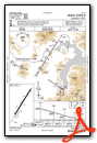
Instrument Approach Procedure (IAP) Charts


Nearby Airports with Instrument Procedures
| ID | Name | Heading / Distance | ||
|---|---|---|---|---|
 |
65S | Boundary County Airport | 022° | 27.7 |
|
KCOE | Coeur D'Alene/Pappy Boyington Field Airport | 198° | 33.2 |
|
KDEW | Deer Park Airport | 240° | 40.2 |
|
S59 | Libby Airport | 090° | 42.9 |
|
KSFF | Felts Field Airport | 219° | 48.1 |
|
KGEG | Spokane International Airport | 224° | 56.7 |
|
KSKA | Fairchild AFB Airport | 227° | 60.3 |
|
KGPI | Glacier Park International Airport | 088° | 92.3 |
|
2S8 | Wilbur Airport | 250° | 93.9 |
|
KPUW | Pullman/Moscow Regional Airport | 193° | 96.2 |
|
8S1 | Polson Airport | 109° | 102.3 |
|
7S0 | Ronan Airport | 112° | 108.5 |
Airport Images
Do you have a recent image of this airport? Upload it here!


