Login
Register


T92
Mason County Airport
Official FAA Data Effective 2025-11-27 0901Z
Chart Supplement

VFR Chart of T92
Sectional Charts at SkyVector.com
IFR Chart of T92
Enroute Charts at SkyVector.com
Location Information for T92
Coordinates: N30°43.93' / W99°11.04'Located 03 miles SE of Mason, Texas on 232 acres of land. View all Airports in Texas.
Surveyed Elevation is 1514 feet MSL.
Operations Data
|
|
Airport Communications
| CTAF: | 122.900 |
|---|---|
| AWOS-3 at AQO (27.2 E): | 119.425 325-247-2189 |
| AWOS-3 at BBD (27.6 N): | 118.375 325-597-9139 |
| ASOS at JCT (32.7 SW): | 119.275 325-244-2722 |
- APCH/DEP CTL SVC PRVDD BY HOUSTON ARTCC (ZHU) ON FREQS 132.35/317.5 (LOMETA RCAG).
Nearby Navigation Aids
|
| ||||||||||||||||||||||||||||||||||||||||||||||||||||||||||||


Runway 18/36
| Dimensions: | 3716 x 50 feet / 1133 x 15 meters | |
|---|---|---|
| Surface: | Asphalt in Fair Condition | |
| Edge Lighting: | Low Intensity | |
| Runway 18 | Runway 36 | |
| Coordinates: | N30°44.24' / W99°11.05' | N30°43.63' / W99°11.06' |
| Elevation: | 1501.8 | 1497.9 |
| Traffic Pattern: | Left | Left |
| Runway Heading: | 181° True | 1° True |
| Markings: | Non-Precision Instrument in good condition. | Non-Precision Instrument in good condition. |
| Glide Slope Indicator | P2L (3.25° Glide Path Angle) | P2L (3.00° Glide Path Angle) |
| Obstacles: | 29 ft Trees 965 ft from runway | |
Services Available
| Fuel: | 100LL (blue) |
|---|---|
| Transient Storage: | Tiedowns |
| Airframe Repair: | NOT AVAILABLE |
| Engine Repair: | NOT AVAILABLE |
| Bottled Oxygen: | NONE |
| Bulk Oxygen: | NONE |
Ownership Information
| Ownership: | Publicly owned | |
|---|---|---|
| Owner: | MASON COUNTY | |
| COURTHOUSE, 201 FT MCKAVITT | ||
| MASON, TX 76856 | ||
| 325-347-5556 | ||
| Manager: | C. SHEREE HARDIN | COUNTY JUDGE/ARPT MGR. |
| COUNTY COURTHOUSE, 201 FT MCKAVITT | ||
| MASON, TX 76856 | ||
| 325-347-5556 | ||
Other Remarks
- HVY TSNT TFC NOV-JAN.
- DEER ON AND INVOF RWY.
- FOR CD CTC HOUSTON ARTCC AT 281-230-5622.
- 0LL FUEL 24 HRS SELF SERVE. FOR ASSITANCE CALL 325-347-5252 (COUNTY SHERIFF).
Weather Minimums
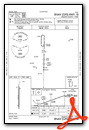
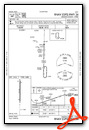
Instrument Approach Procedure (IAP) Charts
Nearby Airports with Instrument Procedures
| ID | Name | Heading / Distance | ||
|---|---|---|---|---|
 |
KAQO | Llano Municipal Airport | 083° | 27.3 |
|
KBBD | Curtis Field Airport | 344° | 27.7 |
|
T82 | Gillespie County Airport | 153° | 32.6 |
|
KJCT | Kimble County Airport | 246° | 32.8 |
|
81R | San Saba County Municipal Airport | 038° | 38.6 |
|
KERV | Kerrville Municipal/Louis Schreiner Field Airport | 173° | 45.5 |
|
KBMQ | Burnet Municipal/Kate Craddock Field Airport | 089° | 48.9 |
|
KLZZ | Lampasas Airport | 066° | 55.7 |
|
KRYW | Lago Vista Tx/Rusty Allen Airport | 102° | 64.4 |
|
KBWD | Brownwood Regional Airport | 010° | 64.6 |
|
3R9 | Lakeway Airpark Airport | 109° | 65.6 |
|
5C1 | Boerne Stage Airfield Airport | 157° | 65.5 |
Airport Images
Do you have a recent image of this airport? Upload it here!


