Login
Register


M40
Monroe County Airport
Official FAA Data Effective 2026-02-19 0901Z
Chart Supplement

VFR Chart of M40
Sectional Charts at SkyVector.com
IFR Chart of M40
Enroute Charts at SkyVector.com
Location Information for M40
Coordinates: N33°52.43' / W88°29.38'Located 04 miles NE of Aberdeen/Amory, Mississippi on 320 acres of land. View all Airports in Mississippi.
Surveyed Elevation is 225 feet MSL.
Operations Data
|
|
Airport Communications
| AWOS-3P: | 118.475 Tel. 662-369-3498 |
|---|---|
| COLUMBUS APPROACH: | 126.075 239.25 |
| COLUMBUS DEPARTURE: | 126.075 239.25 |
| UNICOM: | 122.800 |
| CTAF: | 122.800 |
| ATIS at CBM (13.9 S): | 115.2T |
| ASOS at CBM (13.9 S): | 354.6 |
| ATIS at GTR (26.0 S): | 126.375 |
- APCH/DEP SVC PRVDD BY MEMPHIS ARTCC (COLUMBUS RCAG) ON FREQS 127.1/269.4 WHEN COLUMBUS APCH CTL CLSD.
Nearby Navigation Aids
|
| ||||||||||||||||||||||||||||||||||||||||||||||||||||||


Runway 18/36
| Dimensions: | 4999 x 75 feet / 1524 x 23 meters | |
|---|---|---|
| Surface: | Asphalt in Poor Condition NMRS CRACKS. | |
| Weight Limits: | S-21 | |
| Edge Lighting: | Medium Intensity | |
| Runway 18 | Runway 36 | |
| Coordinates: | N33°52.83' / W88°29.33' | N33°52.02' / W88°29.43' |
| Elevation: | 222.6 | 225.4 |
| Traffic Pattern: | Left | Left |
| Runway Heading: | 186° True | 6° True |
| Markings: | Non-Precision Instrument in fair condition. | Non-Precision Instrument in fair condition. |
| Glide Slope Indicator | P4L (3.00° Glide Path Angle) | P4L (3.00° Glide Path Angle) UNUSBL BYD 9 DEGS R OF CNTRLN. |
| REIL: | Yes | Yes |
| Obstacles: | ft Trees ft from runway | 37 ft Trees 1600 ft from runway |
Services Available
| Fuel: | 100LL (blue), Jet-A |
|---|---|
| Transient Storage: | Hangars,Tiedowns PILOTS MUST PRVD THEIR OWN TIEDOWN ROPES. |
| Airframe Repair: | MAJOR |
| Engine Repair: | MAJOR |
| Bottled Oxygen: | NONE |
| Bulk Oxygen: | NONE |
Ownership Information
| Ownership: | Publicly owned | |
|---|---|---|
| Owner: | MONROE COUNTY | RUBEL WEST, BOARD PRESIDENT. |
| PO BOX 578 | ||
| ABERDEEN, MS 39730 | ||
| 662-369-8143 | ||
| Manager: | WES KIRKPATRICK | |
| 50068 AIRPORT RD | ||
| ABERDEEN, MS 39730 | ||
| 662-369-4800 | 662-436-6122. | |
Other Remarks
- FOR CD CTC COLUMBUS APCH AT 662-434-3044.
- COURTESY CAR AVBL.
- 0LL 24 HR WITH CREDIT CARD.
- AFT HR JET A FUEL CALL 662-436-6122.
- ACTVT REIL RWY 18 & 36; MIRL RWY 18/36; TWY LGTS - CTAF. PAPI RWY 18 & 36 OPR CONSLY.
Weather Minimums

Instrument Approach Procedure (IAP) Charts
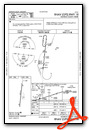
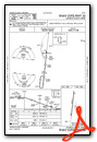
Nearby Airports with Instrument Procedures
| ID | Name | Heading / Distance | ||
|---|---|---|---|---|
 |
KCBM | Columbus AFB Airport | 170° | 13.9 |
|
5A4 | Okolona Municipal/Richard Stovall Field Airport | 305° | 14.6 |
|
M55 | Lamar County Airport | 094° | 18.8 |
|
M83 | Mccharen Field Airport | 207° | 19.5 |
|
M51 | Oktibbeha Airport | 203° | 24.5 |
|
KUBS | Columbus-Lowndes County Airport | 167° | 25.1 |
|
KGTR | Golden Triangle Regional Airport | 191° | 26.0 |
|
KTUP | Tupelo Regional Airport | 329° | 27.5 |
|
KHAB | Marion County-Rankin Fite Airport | 059° | 28.5 |
|
KSTF | George M Bryan Airport | 214° | 31.9 |
|
M95 | Richard Arthur Field Airport | 106° | 35.1 |
|
3M8 | North Pickens Airport | 140° | 37.9 |
Fuel Providers

Airport Images
Do you have a recent image of this airport? Upload it here!


