Login
Register


U82
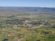
Council Municipal Airport
Official FAA Data Effective 2025-11-27 0901Z
Chart Supplement

VFR Chart of U82
Sectional Charts at SkyVector.com
IFR Chart of U82
Enroute Charts at SkyVector.com
Location Information for U82
Coordinates: N44°45.02' / W116°26.70'Located 01 miles NW of Council, Idaho on 110 acres of land. View all Airports in Idaho.
Surveyed Elevation is 2966 feet MSL.
Operations Data
|
|
Airport Communications
| CTAF: | 122.800 |
|---|---|
| UNICOM: | 122.800 |
| ASOS at MYL (17.1 NE): | 119.925 208-634-5947 |
| AWOS-3P at JSY (50.0 NW): | 123.775 541 432 0458 |
| ASOS at ONO (50.1 SW): | 135.275 541-889-7388 |
- COMMUNICATIONS PRVDD BY BOISE RADIO ON FREQ 122.5 (CASCADE RCO).
Nearby Navigation Aids
|
| ||||||||||||||||||||||||||||||


Runway 17/35
| Dimensions: | 3600 x 60 feet / 1097 x 18 meters | |
|---|---|---|
| Surface: | Asphalt in Fair Condition | |
| Weight Limits: | S-12 | |
| Edge Lighting: | Medium Intensity | |
| Runway 17 | Runway 35 | |
| Coordinates: | N44°45.31' / W116°26.63' | N44°44.73' / W116°26.77' |
| Elevation: | 2966.0 | 2932.0 |
| Traffic Pattern: | Left | Left |
| Runway Heading: | 190° True | 10° True |
| Markings: | Basic in good condition. | Basic in good condition. |
| Obstacles: | 10 ft Brush 350 ft from runway, 100 ft left of center | |
Services Available
| Fuel: | 100LL (blue) |
|---|---|
| Transient Storage: | Tiedowns |
| Airframe Repair: | NONE |
| Engine Repair: | NONE |
| Bottled Oxygen: | NONE |
| Bulk Oxygen: | NONE |
Ownership Information
| Ownership: | Publicly owned | |
|---|---|---|
| Owner: | CITY OF COUNCIL | |
| PO BOX 606 | ||
| COUNCIL, ID 83612-0606 | ||
| 208-253-4201 | ||
| Manager: | KATHRYN HUGHES | |
| P O BOX 606 | ||
| COUNCIL, ID 83612 | ||
| 810-516-4028 | ||
Other Remarks
- ARPT SURROUNDED BY MTNS ALL QUADRANTS.
- FOR CD CTC SALT LAKE ARTCC AT 801-320-2568.
- ACTVT MIRL RY 17/35 - CTAF.
Nearby Airports with Instrument Procedures
| ID | Name | Heading / Distance | ||
|---|---|---|---|---|
 |
KMYL | Mc Call Municipal Airport | 060° | 16.9 |
|
S87 | Weiser Municipal Airport | 214° | 39.5 |
|
KJSY | Joseph State Airport | 317° | 50.2 |
|
KONO | Ontario Municipal Airport | 209° | 50.2 |
|
KBKE | Baker City Municipal Airport | 275° | 58.5 |
|
KEUL | Caldwell Exec Airport | 187° | 67.0 |
|
KMAN | Nampa Municipal Airport | 182° | 70.2 |
|
KBOI | Boise Air Trml/Gowen Field Airport | 172° | 71.8 |
|
KGIC | Idaho County Airport | 010° | 72.8 |
|
KLGD | La Grande/Union County Airport | 296° | 73.9 |
|
KLWS | Lewiston/Nez Perce County Airport | 346° | 100.4 |
|
U76 | Mountain Home Municipal Airport | 162° | 101.9 |