Login
Register
VGT
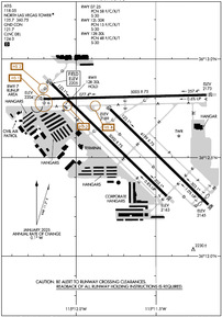
North Las Vegas Airport
Official FAA Data Effective 2026-01-22 0901Z
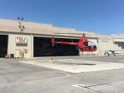
From the Flight Deck
VFR Chart of KVGT
Sectional Charts at SkyVector.com
IFR Chart of KVGT
Enroute Charts at SkyVector.com
Location Information for KVGT
Coordinates: N36°12.64' / W115°11.67'Located 03 miles NW of Las Vegas, Nevada on 920 acres of land. View all Airports in Nevada.
Surveyed Elevation is 2205 feet MSL.
Operations Data
|
|
Airport Communications
| ATIS: | 118.05 (702-631-7125) |
|---|---|
| ASOS: | 118.05 Tel. 702-648-6633 |
| NORTH LAS VEGAS TOWER: | 119.15 125.7 360.75 |
| NORTH LAS VEGAS GROUND: | 121.7 |
| LAS VEGAS APPROACH: | 119.4 360.85 ;RWY 30 118.125 ;RWY 12 291.725 ;RWY 12 |
| LAS VEGAS DEPARTURE: | 119.4 360.85 ;RWY 12 |
| CLEARANCE DELIVERY: | 124.0 |
| CTAF: | 125.700 |
| UNICOM: | 122.950 |
| NTNDO RNAV STAR: | 125.475 307.25 |
| ATIS at LSV (7.9 E): | 270.1 |
| D-ATIS at LAS (8.1 S): | 132.4 |
| ASOS at LAS (8.5 S): | 702-582-5334 |
- VGT TWR FREQUENCY 119.15 MAY BE USED FOR RWT 12L/30R OPS.
- ALL IFR VISUAL APCH GO-AROUNDS EXPCET CLSD TFC AT VGT.
Nearby Navigation Aids
|
| ||||||||||||||||||||||||||||||||||||
Runway 07/25
| Dimensions: | 5005 x 75 feet / 1526 x 23 meters | |
|---|---|---|
| Surface: | Asphalt in Good Condition | |
| Weight Limits: | 58 /F/C/X/T, S-30 | |
| Edge Lighting: | Medium Intensity | |
| Runway 07 | Runway 25 | |
| Coordinates: | N36°12.80' / W115°12.20' | N36°12.82' / W115°11.18' |
| Elevation: | 2204.2 | 2172.5 |
| Runway Heading: | 88° True | 268° True |
| Declared Distances: | TORA:5005 TODA:5005 ASDA:5005 LDA:5005 | TORA:5005 TODA:5005 ASDA:5005 LDA:5005 |
| Markings: | Basic in good condition. | Basic in good condition. |
| Glide Slope Indicator | P4L (3.00° Glide Path Angle) | P4L (3.00° Glide Path Angle) |
| REIL: | Yes | Yes |
| Obstacles: | 50 ft Pole 1434 ft from runway | |
Runway 12R/30L
| Dimensions: | 5000 x 75 feet / 1524 x 23 meters | |
|---|---|---|
| Surface: | Asphalt in Good Condition | |
| Weight Limits: | 48 /F/C/X/T, S-30 | |
| Edge Lighting: | Medium Intensity | |
| Runway 12R | Runway 30L | |
| Coordinates: | N36°12.88' / W115°12.16' | N36°12.30' / W115°11.43' |
| Elevation: | 2205.0 | 2163.0 |
| Runway Heading: | 134° True | 314° True |
| Declared Distances: | TORA:5000 TODA:5000 ASDA:5000 LDA:5000 | TORA:5000 TODA:5000 ASDA:5000 LDA:5000 |
| Markings: | Non-Precision Instrument in good condition. | Non-Precision Instrument in good condition. |
| Glide Slope Indicator | P4L (3.00° Glide Path Angle) | P4L (3.00° Glide Path Angle) |
| REIL: | Yes | Yes |
| Obstacles: | 45 ft Building 1500 ft from runway | |
Runway 12L/30R
| Dimensions: | 4199 x 75 feet / 1280 x 23 meters | |
|---|---|---|
| Surface: | Asphalt in Good Condition | |
| Weight Limits: | 15 /F/C/X/T, S-30 | |
| Edge Lighting: | Medium Intensity | |
| Runway 12L | Runway 30R | |
| Coordinates: | N36°12.75' / W115°11.79' | N36°12.26' / W115°11.17' |
| Elevation: | 2188.6 | 2145.1 |
| Runway Heading: | 134° True | 314° True |
| Displaced Threshold: | 199 Feet | |
| Declared Distances: | TORA:4199 TODA:4199 ASDA:4199 LDA:4199 | TORA:4199 TODA:4199 ASDA:4199 LDA:4000 |
| Markings: | Precision Instrument in good condition. | Basic in good condition. |
| Glide Slope Indicator | P4L (3.20° Glide Path Angle) | P4L (3.00° Glide Path Angle) |
| REIL: | Yes | Yes |
| Obstacles: | 45 ft Building 2019 ft from runway | |
Services Available
| Fuel: | 100LL (blue), Jet-A |
|---|---|
| Transient Storage: | Tiedowns |
| Airframe Repair: | MAJOR |
| Engine Repair: | MAJOR |
| Bottled Oxygen: | NOT AVAILABLE |
| Bulk Oxygen: | HIGH |
| Other Services: | AIR AMBULANCE SERVICES,AVIONICS,CARGO HANDLING SERVICES,CHARTER SERVICE,PILOT INSTRUCTION,AIRCRAFT RENTAL,AIRCRAFT SALES |
Ownership Information
| Ownership: | Publicly owned | |
|---|---|---|
| Owner: | CLARK COUNTY | |
| 2730 AIRPORT DR SUITE 101 | ||
| NORTH LAS VEGAS, NV 89032 | ||
| 702-261-3803 | ||
| Manager: | KARINA TARNOWSKA | MGR. ALSO 702-261-3802. 702.261.3804, NORTH LAS VEGAS AIRPORT 2730 AIRPORT DRIVE, SUITE 101 NORTH LAS VEGAS, NV 89032 |
| 2730 AIRPORT DR SUITE 101 | ||
| NORTH LAS VEGAS, NV 89032 | ||
| 702-261-3804 | ||
Other Remarks
- AIMING POINT MKD AT 1000 FT - ALL RWYS.
- RWY GUARD LGTS AT ALL INTXNS.
- FOR CD WHEN ATCT IS CLSD CTC LAS APCH ON 124.0 OR PH 725-200-4432.
- WHEN SPL EVENT PRKG PPR PROGRAM NOTAM IS ACTV, TSNT ACFT OPERS NOT PERM BASED NEED TO OBTAIN A PPR NR FM AN FBO FOR EA LDG. PPR APPVL & CONFIRMATION NRS CAN BE OBTAINED FM THE SEL FBO AT 702-261-7775. PPR CONFIRMATION NRS SHOULD BE ENTERED IN THE RMKS SECTION OF EACH FLT PLAN.
- RWY 12R CALM WIND RWY.
- ARFF INDEX A, 139.315 (E)
- WHEN ATCT CLSD ACTVT REIL RWY 07 & 25, 12L & 30R, 12R & 30L; PAPI RWY 07 & 25, 12L & 30R, 12R & 30L; MIRL RWY 07/25, 12L/30R, 12R/30L; TWY LGTS - CTAF.
Weather Minimums
Standard Terminal Arrival (STAR) Charts
Instrument Approach Procedure (IAP) Charts
Departure Procedure (DP) Charts
Departure Procedure Obstacles (DPO) Charts
Nearby Airports with Instrument Procedures
| ID | Name | Heading / Distance | ||
|---|---|---|---|---|
 |
KLSV | Nellis AFB Airport | 078° | 7.9 |
 |
KLAS | Harry Reid International Airport | 165° | 8.1 |
 |
KHND | Henderson Exec Airport | 168° | 14.5 |
 |
KBVU | Boulder City Municipal Airport | 134° | 22.6 |
 |
67L | Mesquite Airport | 055° | 66.5 |
 |
KIFP | Laughlin/Bullhead International Airport | 153° | 70.5 |
 |
KIGM | Kingman Airport | 132° | 83.7 |
 |
KEED | Needles Airport | 161° | 90.9 |
 |
KSGU | St George Regional Airport | 058° | 95.2 |
 |
KHII | Lake Havasu City Airport | 157° | 106.4 |
 |
KDAG | Barstow-Daggett Airport | 224° | 112.6 |
 |
KAZC | Colorado City Municipal Airport | 066° | 114.5 |


