Login
Register


X51
Miami Homestead General Aviation Airport
Official FAA Data Effective 2026-02-19 0901Z
Chart Supplement

VFR Chart of X51
Sectional Charts at SkyVector.com
IFR Chart of X51
Enroute Charts at SkyVector.com
Location Information for X51
Coordinates: N25°29.95' / W80°33.25'Located 04 miles NW of Homestead, Florida on 807 acres of land. View all Airports in Florida.
Surveyed Elevation is 7 feet MSL.
Operations Data
|
|
Airport Communications
| AWOS-3: | 118.375 Tel. 321-385-0383 |
|---|---|
| MIAMI APPROACH: | 125.5 354.1 |
| MIAMI DEPARTURE: | 125.5 354.1 |
| SNDBR STAR: | 120.5 350.225 |
| ALTNN DP: | 125.5 354.1 |
| BNFSH STAR: | 124.85 263.025 |
| CSTAL STAR: | 124.85 263.025 |
| PALMZ STAR: | 120.5 350.225 |
| HURCN DP: | 125.5 354.1 |
| FROGZ STAR: | 120.5 350.225 |
| MELLZ DP: | 125.5 354.1 |
| VACAY DP: | 125.5 |
| FOLZZ DP: | 125.5 354.1 |
| DORRL DP: | 125.5 354.1 |
| BNGOS DP: | 125.5 354.1 |
| CTAF: | 122.800 |
| UNICOM: | 122.800 |
| LIFRR DP: | 125.5 354.1 |
| MAYNR DP: | 125.5 354.1 |
| TARPN STAR: | 126.05 ;9000 FT 133.775 ;7000 FT 251.1 ;9000 FT 371.9 ;7000 FT 124.6 ;12000 FT 317.4 ;12000 FT |
| FLMGO DP: | 125.5 354.1 |
| FOWEE STAR: | 120.5 350.225 |
| LUUCE STAR: | 126.05 ;9000 FT 133.775 ;7000 FT 251.1 ;9000 FT 371.9 ;7000 FT |
| VIICE STAR: | 120.5 350.225 |
| ATIS at HST (9.3 E): | 269.9 |
| ATIS at TMB (11.1 NE): | 124.0 |
| ASOS at TMB (11.1 NE): | 124.0 305-235-1332 |
Nearby Navigation Aids
|
| ||||||||||||||||||||||||||||||||||||||||||


Runway 18/36
| Dimensions: | 4001 x 100 feet / 1220 x 30 meters | |
|---|---|---|
| Surface: | Asphalt in Good Condition | |
| Weight Limits: | 12 /F/A/Y/T, S-40, D-65, ST-110 | |
| Edge Lighting: | Medium Intensity | |
| Runway 18 | Runway 36 | |
| Coordinates: | N25°30.13' / W80°33.42' | N25°29.46' / W80°33.42' |
| Elevation: | 6.9 | 7.0 |
| Traffic Pattern: | Right | Left |
| Runway Heading: | 179° True | 359° True |
| Markings: | Basic in fair condition. | Basic in fair condition. |
| Glide Slope Indicator | P4R (3.00° Glide Path Angle) | |
Runway 10/28
| Dimensions: | 3000 x 75 feet / 914 x 23 meters | |
|---|---|---|
| Surface: | Asphalt / Grooved in Excellent Condition | |
| Weight Limits: | 5 /F/A/Y/T, S-20 | |
| Edge Lighting: | Medium Intensity | |
| Runway 10 | Runway 28 | |
| Coordinates: | N25°30.16' / W80°33.31' | N25°30.17' / W80°32.76' |
| Elevation: | 6.0 | 6.9 |
| Traffic Pattern: | Left | Right |
| Runway Heading: | 90° True | 270° True |
| Markings: | Non-Precision Instrument in good condition. | Non-Precision Instrument in good condition. |
| Glide Slope Indicator | P2L (3.00° Glide Path Angle) | |
| Obstacles: | 22 ft Tree 1270 ft from runway, 225 ft right of center | |
Runway 09U/27U
| Dimensions: | 2500 x 150 feet / 762 x 46 meters | |
|---|---|---|
| Surface: | Turf in Fair Condition | |
| Runway 09U | Runway 27U | |
| Markings: | Non-Standard in fair condition. | Non-Standard in fair condition. |
| Obstacles: | 46 ft Trees 2270 ft from runway, 40 ft left of center | |
Services Available
| Fuel: | 100LL (blue), Jet-A |
|---|---|
| Transient Storage: | Hangars,Tiedowns |
| Airframe Repair: | MAJOR |
| Engine Repair: | MAJOR |
| Bottled Oxygen: | LOW |
| Bulk Oxygen: | NOT AVAILABLE |
| Other Services: | CHARTER SERVICE,GLIDER SERVICE,PILOT INSTRUCTION,PARACHUTE JUMP ACTIVITY,AIRCRAFT RENTAL,AIRCRAFT SALES,ANNUAL SURVEYING,GLIDER TOWING SERVICES |
Ownership Information
| Ownership: | Publicly owned | |
|---|---|---|
| Owner: | MIAMI-DADE COUNTY | CONTACT PERSON: LIONEL BECKLES |
| MIAMI-DADE AVIATION DEPARTMENT, P.O. BOX 025504 | ||
| MIAMI, FL 33102-5504 | ||
| 305-876-7038 | ||
| Manager: | JOSEPH KINNEBREW | |
| 12800 SOUTHWEST 145TH AVENUE | ||
| MIAMI, FL 33186 | ||
| 305-876-7484 | ||
Other Remarks
- PAJA SE CORNER OF ARPT .
- 24 HR PPR FOR ACFT EQUIPPED WITH WEATHER MODIFICATION OR GEOENGINEERING EQPT 305-247-4883
- AEROBATIC BOX S OF ARPT & E OF RWY 18/36.
- REMOTE CTL MODEL FLYING FLDS 1.8 NM N RWY 18.
- GLIDER ACT 8000 FT & BLW & CROP DUSTING INVOF ARPT.
- FOR CD CTC MIAMI APCH AT 305-869-5432.
- MKD WITH WHITE CONES.
- MKD WITH WHITE CONES.
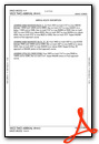
Weather Minimums
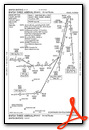
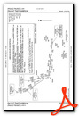
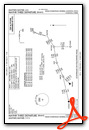
Standard Terminal Arrival (STAR) Charts
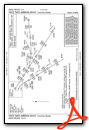
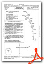
- BNFSH THREE (RNAV)

- BNFSH THREE (RNAV), CONT.1
- BNFSH THREE (RNAV), CONT.2
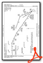
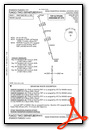
- CSTAL THREE (RNAV)

- CSTAL THREE (RNAV), CONT.1

- CSTAL THREE (RNAV), CONT.2

- FOWEE TWO
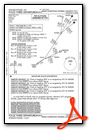
- FROGZ FOUR (RNAV)

- FROGZ FOUR (RNAV), CONT.1

- FROGZ FOUR (RNAV), CONT.2
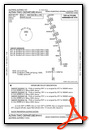
- PALMZ TWO
- SNDBR THREE (RNAV)

- SNDBR THREE (RNAV), CONT.1
- TARPN THREE (RNAV)
- VIICE TWO (RNAV)
- VIICE TWO (RNAV), CONT.1
- VIICE TWO (RNAV), CONT.2
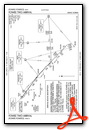
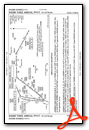
Instrument Approach Procedure (IAP) Charts


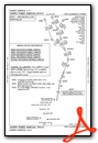
Departure Procedure (DP) Charts


Nearby Airports with Instrument Procedures
| ID | Name | Heading / Distance | ||
|---|---|---|---|---|
 |
KHST | Homestead Arb Airport | 093° | 9.3 |
|
KTMB | Miami Exec Airport | 036° | 11.0 |
|
07FA | Ocean Reef Club Airport | 124° | 18.4 |
|
KMIA | Miami International Airport | 038° | 22.8 |
|
KTNT | Dade-Collier Training and Transition Airport | 319° | 28.6 |
|
KOPF | Miami-Opa Locka Exec Airport | 031° | 28.6 |
|
KHWO | North Perry Airport | 029° | 34.5 |
|
KFLL | Fort Lauderdale/Hollywood International Airport | 032° | 40.7 |
|
KFXE | Fort Lauderdale Exec Airport | 026° | 46.6 |
|
KPMP | Pompano Beach Airpark Airport | 028° | 50.8 |
|
KMTH | The Florida Keys Marathon International Airport | 210° | 53.6 |
|
KBCT | Boca Raton Airport | 024° | 57.9 |


Comments
Legends
It would be a very convenient addition to have links referring to legends as well as glossaries for airport diagrams and charts. For charts the chart user guide and for the airport diagrams its legend
.
Thank you in advance
Yours sincerely
D. Schildmeijer
sofietje
Pages