Login
Register


MIA
Miami International Airport
Official FAA Data Effective 2026-02-19 0901Z
Chart Supplement

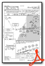
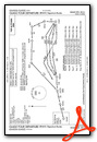
KMIA Airport Diagram

VFR Chart of KMIA
Sectional Charts at SkyVector.com
IFR Chart of KMIA
Enroute Charts at SkyVector.com
Location Information for KMIA
Coordinates: N25°47.72' / W80°17.41'Located 08 miles NW of Miami, Florida on 3300 acres of land. View all Airports in Florida.
Surveyed Elevation is 9 feet MSL.
Operations Data
|
|
Airport Communications
| D-ATIS: | 119.15 ;ARRIVAL (305-869-5446) 133.675 ;DEPART (305-869-5446) |
|---|---|
| ASOS: | 119.15 Tel. 645-231-5974 |
| MIAMI TOWER: | 118.3 ;270-089 123.9 ;090-269 256.9 |
| MIAMI GROUND: | 121.8 ;RWY 08L/26R, 08R/26L, 12 127.5 ;RWY 09/27, 30 348.6 |
| MIAMI APPROACH: | 120.5 ;090-269 124.85 ;270-089 125.75 ;270-089 125.75 132.025 263.025 ;270-089 322.3 ;270-089 379.9 ;090-269 |
| MIAMI DEPARTURE: | 120.5 ;090-269 125.5 ;090-269 125.75 ;270-089 126.85 ;270-089 132.025 290.325 ;270-089 354.1 ;090-269 379.9 ;090-269 |
| IC: | 118.3 ;270-089 121.8 ;RWY 08L/26R, 08R/26L, 12 124.85 ;270-089 126.85 ;270-089 127.5 ;RWY 09/27, 30 256.9 322.3 ;270-089 348.6 |
| CLEARANCE DELIVERY: | 135.35 |
| SNDBR STAR: | 120.5 350.225 |
| ALTNN DP: | 126.85 290.325 |
| KLADA DP: | 125.5 354.1 |
| MIAMI DP: | 125.5 ;GWAVA, KETLL, MAYNR TRANSITIONS 126.85 ;ALTNN,BEECH,BNGOS,DORRL,FLMGO,HURCN,FOLZZ,ZFP 290.325 ;ALTNN,BEECH,BNGOS,DORRL,FLMGO,HURCN,FOLZZ,ZFP 354.1 ;GWAVA, KETLL, MAYNR TRANSITIONS |
| FROGZ STAR: | 120.5 350.225 |
| RTIS: | 125.25 ;120-300 WITHIN 25 NM |
| EMERG: | 121.5 |
| NNOCE DP: | 125.5 354.1 |
| HUSIL DP: | 126.85 290.325 |
| BNGOS DP: | 126.85 290.325 |
| VIICE STAR: | 120.5 350.225 |
| LUUCE STAR: | 126.05 ;9000 FT 133.775 ;7000 FT 251.1 ;9000 FT 371.9 ;7000 FT |
| DVALL STAR: | 120.5 350.225 |
| FLMGO DP: | 126.85 290.325 |
| GWAVA DP: | 125.5 354.1 |
| RAMP CTL: | 120.35 |
| CSTAL STAR: | 124.85 263.025 |
| BNFSH STAR: | 124.85 263.025 |
| FOLZZ DP: | 126.85 290.325 |
| DORRL DP: | 126.85 290.325 |
| HURCN DP: | 126.85 290.325 |
| PALMZ STAR: | 120.5 350.225 |
| LIFRR DP: | 126.85 290.325 |
| MAYNR DP: | 125.5 354.1 |
| UNICOM: | 123.000 |
| FOWEE STAR: | 120.5 124.85 350.225 |
| CLASS B: | 120.5 ;090-269 125.75 ;270-089 322.3 ;270-089 379.9 ;090-269 |
| TARPN STAR: | 126.05 ;9000 FT 133.775 ;7000 FT 251.1 ;9000 FT 371.9 ;7000 FT 124.6 ;12000 FT 317.4 ;12000 FT |
| GLADZ DP: | 125.5 ;DEPARTING WEST 126.85 ;DEPARTING EAST 290.325 ;DEPARTING EAST 354.1 ;DEPARTING WEST |
| ASOS at OPF (6.8 N): | 125.9 305-681-4063 |
| ATIS at OPF (6.8 N): | 125.9 |
| ASOS at TMB (11.8 SW): | 124.0 305-235-1332 |
- ASDE-X IN USE. OPERATE TRANSPONDERS WITH ALTITUDE REPORTING MODE AND ADS-B (IF EQUIPPED) ENABLED ON ALL AIRPORT SURFACES.
Nearby Navigation Aids
|
| ||||||||||||||||||||||||||||||||||||||||||||||||


Runway 09/27
| Dimensions: | 13016 x 150 feet / 3967 x 46 meters | |
|---|---|---|
| Surface: | Asphalt / Grooved in Good Condition | |
| Weight Limits: | S-120, D-250, ST-550, DT-1120
PCR VALUE: 851/F/A/X/T
| |
| Edge Lighting: | High Intensity | |
| Runway 09 | Runway 27 | |
| Coordinates: | N25°47.17' / W80°18.89' | N25°47.26' / W80°16.52' |
| Elevation: | 8.1 | 9.0 |
| Traffic Pattern: | Right | Left |
| Runway Heading: | 87° True | 267° True |
| Displaced Threshold: | 1358 Feet | 261 Feet |
| Declared Distances: | TORA:13016 TODA:13016 ASDA:12755 LDA:11397 | TORA:13016 TODA:13016 ASDA:13016 LDA:12755 |
| Markings: | Precision Instrument in good condition. | Precision Instrument in good condition. |
| Glide Slope Indicator | P4L (3.00° Glide Path Angle) | P4L (3.00° Glide Path Angle) |
| RVR Equipment | Touchdown Midfield Rollout | Touchdown Midfield Rollout |
| Approach Lights: | MALSR 1,400 Foot Medium-intensity Approach Lighting System with runway alignment indicator lights. | MALSR 1,400 Foot Medium-intensity Approach Lighting System with runway alignment indicator lights. |
| Centerline Lights: | Yes | Yes |
| Obstacles: | 23 ft Railroad 750 ft from runway, 580 ft right of center APCH RATIO 50:1 TO DSPLCD THR. |
|
Runway 08R/26L
| Dimensions: | 10506 x 200 feet / 3202 x 61 meters | |
|---|---|---|
| Surface: | Asphalt / Grooved in Good Condition | |
| Weight Limits: | S-120, D-250, ST-550, DT-1120
PCR VALUE: 851/F/A/X/T
| |
| Edge Lighting: | High Intensity | |
| Runway 08R | Runway 26L | |
| Coordinates: | N25°48.04' / W80°18.09' | N25°48.12' / W80°16.17' |
| Elevation: | 8.5 | 8.9 |
| Traffic Pattern: | Left | Right |
| Runway Heading: | 87° True | 267° True |
| Declared Distances: | TORA:10506 TODA:10506 ASDA:10506 LDA:10506 | TORA:10506 TODA:10506 ASDA:10220 LDA:10220 |
| Markings: | Precision Instrument in good condition. | Precision Instrument in good condition. |
| Glide Slope Indicator | P4L (3.00° Glide Path Angle) | P4L (3.00° Glide Path Angle) |
| RVR Equipment | Touchdown Rollout | Touchdown Rollout |
| Approach Lights: | MALSR 1,400 Foot Medium-intensity Approach Lighting System with runway alignment indicator lights. | MALSF 1,400 Foot Medium-intensity Approach Lighting System with sequenced flashers. |
| Centerline Lights: | Yes | Yes |
Runway 12/30
RWY 12/30 CLSD 0300-1200++ WHEN RWY 08R/26L & RWY 09/27 ARE IN USE. | ||
| Dimensions: | 9360 x 150 feet / 2853 x 46 meters | |
|---|---|---|
| Surface: | Asphalt / Grooved in Good Condition | |
| Weight Limits: | S-120, D-250, ST-550, DT-1120
PCR VALUE: 780/F/A/X/T
| |
| Edge Lighting: | High Intensity | |
| Runway 12 | Runway 30 | |
| Coordinates: | N25°47.96' / W80°18.14' | N25°47.20' / W80°16.65' |
| Elevation: | 9.1 | 8.7 |
| Runway Heading: | 119° True | 299° True |
| Displaced Threshold: | 945 Feet | |
| Declared Distances: | TORA:9355 TODA:9355 ASDA:8579 LDA:8579 | TORA:9355 TODA:9355 ASDA:8853 LDA:7913 |
| Markings: | Precision Instrument in good condition. | Precision Instrument in good condition. |
| Glide Slope Indicator | P4R (3.00° Glide Path Angle) | P4L (3.00° Glide Path Angle) |
| RVR Equipment | Touchdown Rollout | Touchdown Rollout |
| Approach Lights: | MALSR 1,400 Foot Medium-intensity Approach Lighting System with runway alignment indicator lights. | MALS 1,400 Foot Medium-intensity Approach Lighting System. |
| Centerline Lights: | Yes | Yes |
| Obstacles: | 40 ft Tower 1700 ft from runway, 200 ft left of center | 52 ft Tree 1600 ft from runway, 300 ft left of center APCH RATIO 48:1 TO DSPLCD THR. +20' RR 200' FM RY END; 450'L. |
Runway 08L/26R
RWY 08L/26R CLSD 0300-1200++ WHEN RWY 08R/26L & RWY 09/27 ARE IN USE. | ||
| Dimensions: | 8600 x 150 feet / 2621 x 46 meters | |
|---|---|---|
| Surface: | Asphalt / Grooved in Good Condition | |
| Weight Limits: | S-120, D-250, ST-550, DT-1120
PCR VALUE: 711/F/A/X/T
| |
| Edge Lighting: | High Intensity | |
| Runway 08L | Runway 26R | |
| Coordinates: | N25°48.17' / W80°18.09' | N25°48.24' / W80°16.53' |
| Elevation: | 8.9 | 8.8 |
| Runway Heading: | 87° True | 267° True |
| Declared Distances: | TORA:8600 TODA:8600 ASDA:8600 LDA:8600 | TORA:8600 TODA:8600 ASDA:8600 LDA:8600 |
| Markings: | Non-Precision Instrument in good condition. | Non-Precision Instrument in good condition. |
| Glide Slope Indicator | P4L (3.00° Glide Path Angle) | P4L (3.00° Glide Path Angle) |
| REIL: | Yes | Yes |
| Centerline Lights: | Yes | Yes |
Services Available
| Fuel: | 100 (green), Jet-A |
|---|---|
| Transient Storage: | Hangars,Tiedowns |
| Airframe Repair: | MAJOR |
| Engine Repair: | MAJOR |
| Bottled Oxygen: | HIGH/LOW |
| Bulk Oxygen: | HIGH/LOW |
| Other Services: | AIR FREIGHT SERVICES,CROP DUSTING SERVICES,CARGO HANDLING SERVICES,CHARTER SERVICE |
Ownership Information
| Ownership: | Publicly owned | |
|---|---|---|
| Owner: | DADE COUNTY AVIATON DEPT | |
| PO BOX 025504 | ||
| MIAMI, FL 33102-5504 | ||
| 305-876-7077 | ||
| Manager: | RALPH CUTIE | JIM MURPHY, AIRPORT SUPERVISOR 305-876-7516. |
| MIAMI-DADE AVIATION DEPARTMENT, P.O. BOX 025504 | ||
| MIAMI, FL 33102-5504 | ||
| 305-876-7038 | ||
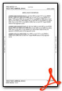
Other Remarks
- CLSD NON ENG ACFT.
- PPR 3 HRS PRIOR TO ALL ARRIVALS ON THE GENERAL AVIATION CENTER (GAC) RAMP 305-876-7550 CTC RAMP CONTROL UPON ARRIVAL ON FREQUENCY 131.600. ACFT WITH WINGSPAN GREATER THAN 78 FT ARE PROHIBITED FROM ENTERING THE GAC RAMP.
- ALL MEDICAL EMERGENCIES ARRIVALS, WITH THE EXCEPTION OF AIR AMBULANCE FLIGHTS, MUST SECURE DOORS UNTIL ARFF IS ON SCENE.
- PPR FOR INBOUND MILITARY FLIGHTS 100 NM ON FREQ 130.5.
- ALL DIVERSION CTC FREQ 130.5 UPON ARR.
- AIRPORT MANAGER: 305-876-7038.
- AIRPORT OPS 305-876-7550.
- US CBP AND EAPIS AVBL.
- RWY 12-30 CLSD 0300-1200Z++ WHEN RWY 08R-26L AND RWY 09-27 ARE IN USE.
- RWY 08L-26R CLSD 0300-1200Z++ WHEN RWY 08R-26L AND RWY 09-27 ARE IN USE.
- ALL TBJT ACFT ARE REQD TO USE DSNT NOISE ABATEMENT DEP PROFILE (NADP-2) FROM ALL RWYS.
- ACFT WITH A WINGSPAN GTR THAN 171 FT ARE PROHIBITED FM TXG ON TWY P E OF TWY U, EXCEPT ADG VI ACFT COMPLYING WITH MIA ADG VI OPERATIONAL PLAN WHEN ADJ AIRSIDE SVC ROAD IS CLSD TO TRAFFIC.
- TRML APN TXY SPOTS 2, 4, 13,15, 22 AND 24 MAX SPAN 125 FT OR LESS. TRML APN TXY SPOTS 26, 28 MAX SPAN 167 FT OR LESS
- 24 HR PPR FOR ACFT EQUIPPED WITH WEATHER MODIFICATION OR GEOENGINEERING EQPT 305-876-7550.
- BIRDS ON & INVOF ARPT.
Weather Minimums

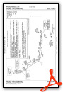
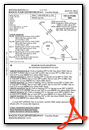
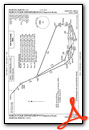
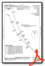
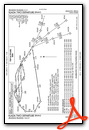
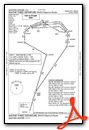
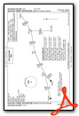
Standard Terminal Arrival (STAR) Charts
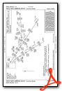
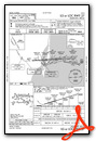
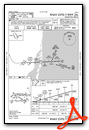
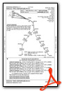
- BNFSH THREE (RNAV)

- BNFSH THREE (RNAV), CONT.1
- BNFSH THREE (RNAV), CONT.2
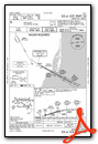
- CSTAL THREE (RNAV)

- CSTAL THREE (RNAV), CONT.1

- CSTAL THREE (RNAV), CONT.2

- DVALL FOUR

- FOWEE TWO
- FROGZ FOUR (RNAV)

- FROGZ FOUR (RNAV), CONT.1

- FROGZ FOUR (RNAV), CONT.2
- PALMZ TWO
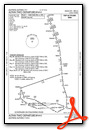
- SNDBR THREE (RNAV)

- SNDBR THREE (RNAV), CONT.1
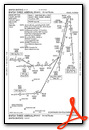
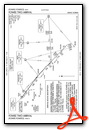
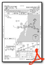
- TARPN THREE (RNAV)
- VIICE TWO (RNAV)
- VIICE TWO (RNAV), CONT.1
- VIICE TWO (RNAV), CONT.2
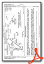
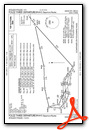
Instrument Approach Procedure (IAP) Charts
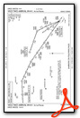
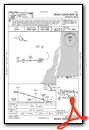
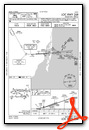
- ILS OR LOC RWY 08R

- ILS OR LOC RWY 09

- ILS OR LOC RWY 12

- ILS OR LOC RWY 26L
- ILS OR LOC RWY 27
- ILS OR LOC RWY 30
- RNAV (RNP) Y RWY 08R

- RNAV (RNP) Y RWY 12

- RNAV (RNP) Y RWY 30

- RNAV (RNP) Z RWY 26L

- RNAV (RNP) Z RWY 27

- RNAV (GPS) RWY 08L
- RNAV (GPS) RWY 09

- RNAV (GPS) RWY 26R
- RNAV (GPS) Y RWY 26L
- RNAV (GPS) Y RWY 27

- RNAV (GPS) Z RWY 08R

- RNAV (GPS) Z RWY 12

- RNAV (GPS) Z RWY 30

- LOC RWY 08L

- LOC RWY 26R
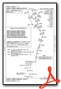
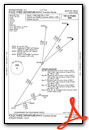
Departure Procedure (DP) Charts
- RNAV DP AAUP

- ALTNN TWO (RNAV)
- ALTNN TWO (RNAV), CONT.1
- BNGOS FOUR (RNAV)

- BNGOS FOUR (RNAV), CONT.1
- DORRL TWO (RNAV)

- DORRL TWO (RNAV), CONT.1

- FLMGO TWO (RNAV)

- FLMGO TWO (RNAV), CONT.1

- FOLZZ THREE (RNAV)
- FOLZZ THREE (RNAV), CONT.1
- FOLZZ THREE (RNAV), CONT.2

- GLADZ FOUR (RNAV)
- GLADZ FOUR (RNAV), CONT.1

- GLADZ FOUR (RNAV), CONT.2

- GWAVA TWO (RNAV)

- GWAVA TWO (RNAV), CONT.1

- HURCN FOUR (RNAV)
- HURCN FOUR (RNAV), CONT.1
- HURCN FOUR (RNAV), CONT.2
- KLADA TWO (RNAV)
- KLADA TWO (RNAV), CONT.1

- LIFRR TWO (RNAV)

- LIFRR TWO (RNAV), CONT.1
- MAYNR THREE (RNAV)
- MAYNR THREE (RNAV), CONT.1
- MAYNR THREE (RNAV), CONT.2
- MIAMI TWO

- MIAMI TWO, CONT.1

- NNOCE TWO (RNAV)
Nearby Airports with Instrument Procedures
| ID | Name | Heading / Distance | ||
|---|---|---|---|---|
 |
KOPF | Miami-Opa Locka Exec Airport | 005° | 6.7 |
|
KTMB | Miami Exec Airport | 221° | 11.8 |
|
KHWO | North Perry Airport | 012° | 12.6 |
|
KFLL | Fort Lauderdale/Hollywood International Airport | 024° | 18.2 |
|
KHST | Homestead Arb Airport | 195° | 19.0 |
|
X51 | Miami Homestead General Aviation Airport | 219° | 22.8 |
|
KFXE | Fort Lauderdale Exec Airport | 015° | 24.9 |
|
07FA | Ocean Reef Club Airport | 178° | 28.2 |
|
KPMP | Pompano Beach Airpark Airport | 019° | 28.7 |
|
KTNT | Dade-Collier Training and Transition Airport | 277° | 33.1 |
|
KBCT | Boca Raton Airport | 015° | 36.2 |
|
KLNA | Palm Beach County Park Airport | 013° | 49.0 |
Airport Images
Do you have a recent image of this airport? Upload it here!


