Login
Register


DWX
Dixon Airport
Official FAA Data Effective 2024-10-03 0901Z
Chart Supplement

VFR Chart of KDWX
Sectional Charts at SkyVector.com
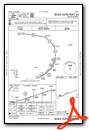
IFR Chart of KDWX
Enroute Charts at SkyVector.com
Location Information for KDWX
Coordinates: N41°2.25' / W107°29.55'Located 02 miles E of Dixon, Wyoming on 150 acres of land. View all Airports in Wyoming.
Surveyed Elevation is 6548 feet MSL.
Operations Data
|
|
Airport Communications
| AWOS-3PT: | 119.425 Tel. 307-383-2504 |
|---|---|
| CTAF: | 122.900 |
| ASOS at CAG (32.6 S): | 135.425 970-824-2373 |
| AWOS-3PT at HDN (35.7 S): | 119.275 970-276-3690 |
| AWOS-3PT at SAA (38.7 NE): | 118.175 307-326-5387 |
- APCH/DEP CTL SVC PRVDD BY DENVER ARTCC (ZDV) ON FREQS 120.475/235.975 (HAYDEN RCAG).
Nearby Navigation Aids
|
| ||||||||||||||||||||||||||||||||||||

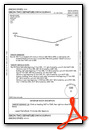
Runway 06/24
| Dimensions: | 7000 x 75 feet / 2134 x 23 meters | |
|---|---|---|
| Surface: | Asphalt in Good Condition | |
| Weight Limits: | S-24 | |
| Edge Lighting: | Medium Intensity | |
| Runway 06 | Runway 24 | |
| Coordinates: | N41°2.06' / W107°30.27' | N41°2.43' / W107°28.83' |
| Elevation: | 6472.5 | 6548.9 |
| Runway Heading: | 71° True | 251° True |
| Markings: | Non-Precision Instrument in fair condition. | Non-Precision Instrument in fair condition. |
| Glide Slope Indicator | P2L (3.00° Glide Path Angle) | |
| REIL: | Yes | Yes |
| Obstacles: | 8 ft Brush 324 ft from runway, 14 ft left of center | |
Services Available
| Fuel: | 100LL (blue) |
|---|---|
| Transient Storage: | Tiedowns PILOT SUPPLIED ROPES REQUIRED FOR TIE DOWNS |
| Airframe Repair: | NONE |
| Engine Repair: | NONE |
| Bottled Oxygen: | NONE |
| Bulk Oxygen: | NONE |
Ownership Information
| Ownership: | Publicly owned | |
|---|---|---|
| Owner: | CARBON COUNTY | |
| PO BOX 6 | ||
| RAWLINS, WY 82301 | ||
| 307-328-2668 | ||
| Manager: | KODY STOCKS | |
| PO BOX 6 | ||
| RAWLINS, WY 82301 | ||
| 307-380-7278 | ||
Other Remarks
- WILDLIFE ON & INVOF ARPT. 6 FT WILDLIFE FENCE ALL AROUND ARPT WITH GATED, CATTLE GUARD ENTRANCES.
- SNOW BANKS +4 FT ALONG ENTIRE RY WINTER MONTHS.
- +500 FT TERRAIN 9700 FT FM AER 24.
- FOR CD CTC DENVER ARTCC AT 303-651-4257.
- COLD TEMPERATURE AIRPORT. ALTITUDE CORRECTION REQUIRED AT OR BELOW -37C.
- 0LL FUEL 24 HR CREDIT CARD SVC AVBL.
- ACTV REILS RWY 6 & 24; PAPI RWY 6, MIRL RWY 06/24 - CTAF.
Weather Minimums

Instrument Approach Procedure (IAP) Charts
Departure Procedure Obstacles (DPO) Charts
Nearby Airports with Instrument Procedures
| ID | Name | Heading / Distance | ||
|---|---|---|---|---|
 |
KCAG | Craig-Moffat Airport | 182° | 32.5 |
|
KHDN | Yampa Valley Airport | 159° | 35.6 |
|
KSAA | Shively Field Airport | 050° | 38.7 |
|
KSBS | Steamboat Springs/Bob Adams Field Airport | 137° | 42.3 |
|
KRWL | Rawlins Municipal/Harvey Field Airport | 015° | 47.9 |
|
33V | Walden-Jackson County Airport | 106° | 58.2 |
|
KEEO | Meeker Coulter Field Airport | 197° | 61.9 |
|
20V | Mc Elroy Airfield Airport | 138° | 78.2 |
|
KRKS | Southwest Wyoming Regional Airport | 295° | 78.6 |
|
4V0 | Rangely Airport | 226° | 81.1 |
|
KLAR | Laramie Regional Airport | 078° | 84.0 |
|
KEGE | Eagle County Regional Airport | 162° | 87.7 |
Airport Images
Do you have a recent image of this airport? Upload it here!


Comments
Fuel Availability
As of 5/17/17 AirNav.com reports 100LL is available for $4.85/gal.