Login
Register
EEN
Dillant/Hopkins Airport
Official FAA Data Effective 2025-04-17 0901Z
VFR Chart of KEEN
Sectional Charts at SkyVector.com
IFR Chart of KEEN
Enroute Charts at SkyVector.com
Location Information for KEEN
Coordinates: N42°53.90' / W72°16.25'Located 02 miles S of Keene, New Hampshire on 939 acres of land. View all Airports in New Hampshire.
Surveyed Elevation is 488 feet MSL.
Operations Data
|
|
Airport Communications
| AWOS-3PT: | 119.025 Tel. 603-358-6424 |
|---|---|
| UNICOM: | 123.000 |
| CTAF: | 123.000 |
| ASOS at AFN (13.0 SE): | 135.875 603-532-6195 |
| ASOS at ORE (19.7 S): | 135.675 978-544-6774 |
| ASOS at VSF (28.8 N): | 121.425 802-886-6006 |
- APCH/DEP SVC PRVDD BY BOSTON ARTCC ON FREQS 123.75/338.2 (GARDNER RCAG).
- COMMUNICATIONS PRVDD BY BANGOR RADIO ON FREQ 122.6 (KEENE RCO).
Nearby Navigation Aids
|
| ||||||||||||||||||||||||||||||||||||||||||||||||||||||||||||
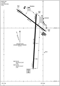
Runway 02/20
| Dimensions: | 6201 x 100 feet / 1890 x 30 meters | |
|---|---|---|
| Surface: | Asphalt in Excellent Condition | |
| Weight Limits: | 40 /F/C/X/T, D-60 | |
| Edge Lighting: | High Intensity | |
| Runway 02 | Runway 20 | |
| Coordinates: | N42°53.24' / W72°16.25' | N42°54.26' / W72°16.17' |
| Elevation: | 488.0 | 482.3 |
| Traffic Pattern: | Left | Left |
| Runway Heading: | 3° True | 183° True |
| Markings: | Precision Instrument in good condition. | Basic in good condition. |
| Glide Slope Indicator | P4L (3.00° Glide Path Angle) | P4L (3.00° Glide Path Angle) PAPI OTS INDEFLY. |
| Approach Lights: | MALSR 1,400 Foot Medium-intensity Approach Lighting System with runway alignment indicator lights. | |
| Obstacles: | 70 ft Tree 974 ft from runway, 540 ft left of center | 112 ft Trees 1665 ft from runway, 541 ft right of center |
Runway 14/32
| Dimensions: | 4001 x 75 feet / 1220 x 23 meters | |
|---|---|---|
| Surface: | Asphalt in Excellent Condition | |
| Weight Limits: | 8 /F/C/X/T, S-25 | |
| Edge Lighting: | Medium Intensity | |
| Runway 14 | Runway 32 | |
| Coordinates: | N42°54.34' / W72°16.66' | N42°53.95' / W72°15.94' |
| Elevation: | 471.5 | 481.9 |
| Traffic Pattern: | Left | Left |
| Runway Heading: | 127° True | 307° True |
| Displaced Threshold: | 1100 Feet | |
| Markings: | Basic in good condition. | Basic in good condition. |
| REIL: | Yes | Yes |
| Obstacles: | 10 ft Trees 355 ft from runway, 37 ft right of center | 48 ft Trees 522 ft from runway, 101 ft right of center APCH RATIO 25:1 TO DTHR. |
Services Available
| Fuel: | 100LL (blue), Jet-A |
|---|---|
| Transient Storage: | Hangars,Tiedowns |
| Airframe Repair: | MAJOR |
| Engine Repair: | MAJOR |
| Bottled Oxygen: | HIGH/LOW |
| Bulk Oxygen: | HIGH/LOW |
| Other Services: | CHARTER SERVICE,PILOT INSTRUCTION,AIRCRAFT RENTAL,AIRCRAFT SALES |
Ownership Information
| Ownership: | Publicly owned | |
|---|---|---|
| Owner: | CITY OF KEENE | |
| 3 WASHINGTON ST | ||
| KEENE, NH 03431 | ||
| 603-357-9835 | ||
| Manager: | DAVID HICKLING | |
| 80 AIRPORT RD | ||
| KEENE, NH 03431 | ||
| 603-357-9835 | ||
Other Remarks
- WILDLIFE ON & INVOF ARPT.
- NOISE ABATEMENT PROC: HEL TFC AVOID RESIDENTIAL AREAS DRCTLY N OF RWY 02-20 & SW OF ARPT. HEL TFC LIMIT MULT CLSD PAT OPS.
- FOR CD IF UNA TO CTC ON FSS FREQ, CTC BOSTON ARTCC AT 603-879-6859.
- COLD TEMPERATURE AIRPORT. ALTITUDE CORRECTION REQUIRED AT OR BELOW -21C.
- NO ENG RUN-UPS ON TRML NW APN.
- GRASS AREAS NOT MNTND FOR TKOFS & LDGS.
- 0LL 100LL AVBL 24 HRS WITH CREDIT CARD. FOR JET FUEL AFT HRS CALL 603-357-7600.
- ACTVT MALSR RWY 02; HIRL RWY 02/20; MIRL RWY 14/32 - CTAF.
Weather Minimums
Instrument Approach Procedure (IAP) Charts
Nearby Airports with Instrument Procedures
| ID | Name | Heading / Distance | ||
|---|---|---|---|---|
 |
KAFN | Jaffrey Airfield Silver Ranch Airport | 115° | 13.1 |
 |
KORE | Orange Municipal Airport | 182° | 19.7 |
 |
0B5 | Turners Falls Airport | 211° | 21.5 |
 |
KGDM | Gardner Municipal Airport | 151° | 23.7 |
 |
KCNH | Claremont Municipal Airport | 351° | 28.6 |
 |
KVSF | Hartness State (Springfield) Airport | 338° | 28.8 |
 |
2B3 | Parlin Field Airport | 007° | 29.5 |
 |
KFIT | Fitchburg Municipal Airport | 132° | 30.6 |
 |
KASH | Boire Field Airport | 101° | 34.1 |
 |
KMHT | Manchester Boston Regional Airport | 086° | 36.9 |
 |
7B2 | Northampton Airport | 203° | 37.4 |
 |
KCON | Concord Municipal Airport | 061° | 38.4 |


