Login
Register
WBW
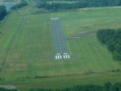
Wilkes-Barre Wyoming Valley Airport
Official FAA Data Effective 2025-01-23 0901Z
VFR Chart of KWBW
Sectional Charts at SkyVector.com
IFR Chart of KWBW
Enroute Charts at SkyVector.com
Location Information for KWBW
Coordinates: N41°17.84' / W75°51.13'Located 03 miles N of Wilkes-Barre, Pennsylvania on 135 acres of land. View all Airports in Pennsylvania.
Surveyed Elevation is 543 feet MSL.
Operations Data
|
|
Airport Communications
| WILKES-BARRE APPROACH: | 126.3 256.7 |
|---|---|
| WILKES-BARRE DEPARTURE: | 126.3 256.7 |
| CTAF: | 122.800 |
| UNICOM: | 122.800 |
| ASOS at AVP (6.2 E): | 570-655-0748 |
| ATIS at AVP (6.3 NE): | 135.75 |
| AWOS-3 at HZL (19.8 S): | 119.975 570-459-4901 |
Nearby Navigation Aids
|
| ||||||||||||||||||||||||||||||||||||||||||||||||||||||||||||
Runway 07/25
| Dimensions: | 3375 x 75 feet / 1029 x 23 meters | |
|---|---|---|
| Surface: | Asphalt in Good Condition | |
| Edge Lighting: | Medium Intensity | |
| Runway 07 | Runway 25 | |
| Coordinates: | N41°17.67' / W75°51.37' | N41°18.00' / W75°50.78' |
| Elevation: | 543.8 | 542.9 |
| Traffic Pattern: | Left | |
| Runway Heading: | 54° True | 234° True |
| Markings: | Non-Precision Instrument in good condition. | Non-Precision Instrument in good condition. |
| Glide Slope Indicator | P2L (4.00° Glide Path Angle) | P2L (3.75° Glide Path Angle) |
| Obstacles: | 120 ft Tree 2286 ft from runway, 528 ft right of center | |
Runway 09/27
RWY 09/27 CLSD WINTER MONTHS. | ||
| Dimensions: | 2193 x 100 feet / 668 x 30 meters RWY 09/27 FIRST 544 FT RWY 27 ASPH, RMNDR TURF. | |
|---|---|---|
| Surface: | Asphalt-Turf in Good Condition | |
| Runway 09 | Runway 27 | |
| Coordinates: | N41°17.81' / W75°51.46' | N41°17.89' / W75°51.00' |
| Elevation: | 541.2 | 542.5 |
| Traffic Pattern: | Left | |
| Runway Heading: | 77° True | 257° True |
| Displaced Threshold: | 672 Feet | |
| Markings: | in good condition. | in good condition. |
| Obstacles: | 94 ft Trees 1107 ft from runway, 136 ft left of center APCH RATIO 18:1 TO DTHR. |
|
Services Available
| Fuel: | 100LL (blue), Jet-A |
|---|---|
| Transient Storage: | Hangars,Tiedowns |
| Airframe Repair: | MAJOR |
| Engine Repair: | MAJOR |
| Bottled Oxygen: | NONE |
| Bulk Oxygen: | NONE |
| Other Services: | AIR FREIGHT SERVICES,CROP DUSTING SERVICES,PILOT INSTRUCTION,AIRCRAFT RENTAL |
Ownership Information
| Ownership: | Publicly owned | |
|---|---|---|
| Owner: | COUNTY OF LUZERNE | |
| 200 N. RIVER ST. | ||
| WILKES-BARRE, PA 18071 | ||
| 570-825-1600 | ||
| Manager: | JIM SCROBOLA | |
| 2001 WYOMING AVE | ||
| FORTY FORT, PA 18704 | ||
| 570-288-3257 | ||
Other Remarks
- +152 FT TRANSMISSION LINES 6000 FT FROM RWY 25 THLD 585 FT L MKD WITH RED SPHERES.
- FOR CD CTC WILKES-BARRE APCH AT 570-655-2084.
- RWY 09/27 MKD WITH 3 FT WHITE CONES. RWY 09; DSPLCD THLD MKD WITH THREE WHITE CONES EACH SIDE.
- ACTVT PAPI RWY 07/25; MIRL RWY 07/25 - CTAF. RWY 07/25 PRESET LOW INTST TO ACTVT HIGHER INTST - CTAF.
- ACTVT ROTG BCN - CTAF.
Weather Minimums
Instrument Approach Procedure (IAP) Charts
Nearby Airports with Instrument Procedures
| ID | Name | Heading / Distance | ||
|---|---|---|---|---|
 |
KAVP | Wilkes-Barre/Scranton International Airport | 066° | 6.3 |
 |
9N3 | Seamans Field Airport | 013° | 18.0 |
 |
KHZL | Hazleton Regional Airport | 199° | 19.7 |
 |
KMPO | Pocono Mountains Regional Airport | 113° | 23.4 |
 |
22N | Jake Arner Memorial Airport | 171° | 29.5 |
 |
N30 | Cherry Ridge Airport | 064° | 30.1 |
 |
N13 | Bloomsburg Municipal Airport | 235° | 32.0 |
 |
N27 | Bradford County Airport | 314° | 37.7 |
 |
8N8 | Danville Airport | 240° | 41.6 |
 |
N79 | Northumberland County Airport | 229° | 42.1 |
 |
KZER | Schuylkill County/Joe Zerbey Airport | 213° | 42.6 |
 |
KABE | Lehigh Valley International Airport | 154° | 43.0 |


