Login
Register
S23
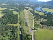
Ione Municipal Airport
Official FAA Data Effective 2024-12-26 0901Z
VFR Chart of S23
Sectional Charts at SkyVector.com
IFR Chart of S23
Enroute Charts at SkyVector.com
Location Information for S23
Coordinates: N48°42.51' / W117°24.79'Located 02 miles S of Ione, Washington on 75 acres of land. View all Airports in Washington.
Estimated Elevation is 2109 feet MSL.
Operations Data
|
|
Airport Communications
| CTAF: | 122.900 |
|---|---|
| AWOS-3 at 63S (21.0 SW): | 119.275 509-684-8994 |
| AWOS-2 at SZT (41.9 SE): | 135.425 208-263-3074 |
| ASOS at DEW (44.1 S): | 135.175 509-276-2303 |
Nearby Navigation Aids
|
| ||||||||||||||||||||||||||||||||||||||||||
Runway 15/33
| Dimensions: | 3643 x 45 feet / 1110 x 14 meters | |
|---|---|---|
| Surface: | Asphalt in Good Condition | |
| Edge Lighting: | Medium Intensity | |
| Runway 15 | Runway 33 | |
| Coordinates: | N48°42.80' / W117°24.89' | N48°42.21' / W117°24.69' |
| Elevation: | 2109.5 | 2106.2 |
| Traffic Pattern: | Left | Left |
| Displaced Threshold: | 222 Feet | |
| Declared Distances: | TORA:3421 TODA:3421 ASDA:3421 LDA:3421 | TORA:3644 TODA:3644 ASDA:3644 LDA:3421 |
| Markings: | Basic in poor condition. | Basic in poor condition. |
| Obstacles: | 8 ft Fence 210 ft from runway | |
Helipad H1
| Dimensions: | 60 x 60 feet / 18 x 18 meters | |
|---|---|---|
| Surface: | Concrete in Good Condition | |
| Edge Lighting: | Medium Intensity | |
| Markings: | Basic in poor condition. | |
Services Available
| Fuel: | NONE |
|---|---|
| Transient Storage: | Tiedowns TIEDOWNS PILOT PROVIDED |
| Airframe Repair: | NONE |
| Engine Repair: | NONE |
| Bottled Oxygen: | NONE |
| Bulk Oxygen: | NONE |
Ownership Information
| Ownership: | Publicly owned | |
|---|---|---|
| Owner: | CITY OF IONE | |
| PO BOX 498 | ||
| IONE, WA 99139 | ||
| 509-442-3611 | ||
| Manager: | MIKE SHIPLEY | |
| PO BOX 104 | ||
| IONE, WA 99139 | ||
| 509-550-8700 | ||
Other Remarks
- WILDLIFE INVOF RY.
- ARPT USED FOR SEASONAL WILDLAND FIRE SPT
- FOR CD CTC SEATTLE ARTCC AT 253-351-3694.
- RWY 15/33 MARKINGS ARE FADED.
- H1 MARKINGS ARE FADED.
Nearby Airports with Instrument Procedures
| ID | Name | Heading / Distance | ||
|---|---|---|---|---|
 |
KSZT | Sandpoint Airport | 125° | 42.0 |
 |
65S | Boundary County Airport | 088° | 44.4 |
 |
KDEW | Deer Park Airport | 180° | 44.5 |
 |
KCOE | Coeur D'Alene/Pappy Boyington Field Airport | 156° | 60.9 |
 |
KSFF | Felts Field Airport | 176° | 61.7 |
 |
KGEG | Spokane International Airport | 184° | 65.6 |
 |
KSKA | Fairchild AFB Airport | 188° | 66.4 |
 |
2S8 | Wilbur Airport | 223° | 78.3 |
 |
S59 | Libby Airport | 107° | 80.9 |
 |
KOMK | Omak Airport | 260° | 85.1 |
 |
CYYF | Penticton Airport | 298° | 97.5 |
 |
KMWH | Grant County International Airport | 221° | 118.4 |


