Login
Register
MSO
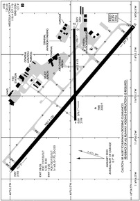
Missoula Montana Airport
Official FAA Data Effective 2025-01-23 0901Z
VFR Chart of KMSO
Sectional Charts at SkyVector.com
IFR Chart of KMSO
Enroute Charts at SkyVector.com
Location Information for KMSO
Coordinates: N46°54.98' / W114°5.43'Located 04 miles NW of Missoula, Montana on 2700 acres of land. View all Airports in Montana.
Surveyed Elevation is 3205 feet MSL.
Operations Data
|
|
Airport Communications
| ATIS: | 126.65 (406-549-2989) |
|---|---|
| ASOS: | Tel. 406-728-3743 |
| MISSOULA TOWER: | 118.4 377.175 |
| MISSOULA GROUND: | 121.9 |
| SPOKANE APPROACH: | 124.9 298.95 |
| SPOKANE DEPARTURE: | 124.9 298.95 |
| IC: | 124.9 298.95 |
| UNICOM: | 122.950 |
| CTAF: | 118.400 |
| AWOS-AV at 32S (23.3 S): | 120.925 406-777-9884 |
| AWOS-2 at 7S0 (39.1 N): | 119.925 406-676-2967 |
| AWOS-3P at HRF (39.6 S): | 119.825 406-375-9149 |
- APCH/DEP CTL SVC PRVDD BY SALT LAKE ARTCC (ZLC) ON FREQS 127.075/244.875 (MILLER PEAK RCAG) WHEN SPOKANE APCH CTL (GEG) IS UNAVBL 2320-0700.
- COMMUNICATIONS PRVDD BY GREAT FALLS RADIO ON FREQ 122.2 (MILLER PEAK RCO).
Nearby Navigation Aids
|
| ||||||||||||||||||||||||||||||
Runway 12/30
| Dimensions: | 9501 x 150 feet / 2896 x 46 meters | |
|---|---|---|
| Surface: | Asphalt / Grooved in Good Condition | |
| Weight Limits: | S-145, D-170, ST-255
180 DEG TURNS FOR ACFT OVR 12500 LBS GWT PROHIBITED ON ALL MOVEMENT AREAS. AVOID LOCKED TURNS AT ALL TIMES.
PCR VALUE: 730/F/D/X/T
| |
| Edge Lighting: | High Intensity | |
| Runway 12 | Runway 30 | |
| Coordinates: | N46°55.49' / W114°6.39' | N46°54.48' / W114°4.66' |
| Elevation: | 3192.4 | 3205.5 |
| Traffic Pattern: | Left | Left |
| Runway Heading: | 130° True | 310° True |
| Declared Distances: | TORA:9501 TODA:9501 ASDA:9501 LDA:9501 | TORA:9501 TODA:9501 ASDA:9501 LDA:9501 |
| Markings: | Precision Instrument in good condition. | Non-Precision Instrument in good condition. |
| Glide Slope Indicator | P4L (3.00° Glide Path Angle) | P4L (3.00° Glide Path Angle) |
| RVR Equipment | Touchdown | Rollout |
| Approach Lights: | MALSR 1,400 Foot Medium-intensity Approach Lighting System with runway alignment indicator lights. | |
| REIL: | Yes | |
Runway 08/26
WHEN TWR CLSD RWY 08/26 CLSD EXC TAXI . | ||
| Dimensions: | 4612 x 75 feet / 1406 x 23 meters | |
|---|---|---|
| Surface: | Asphalt / Grooved in Fair Condition | |
| Weight Limits: | S-30, D-50
PCR VALUE: 175/F/D/X/T
| |
| Edge Lighting: | Medium Intensity | |
| Runway 08 | Runway 26 | |
| Coordinates: | N46°54.96' / W114°5.80' | N46°54.97' / W114°4.69' |
| Elevation: | 3199.2 | 3204.2 |
| Traffic Pattern: | Left | Left |
| Runway Heading: | 89° True | 269° True |
| Declared Distances: | TORA:4612 TODA:4612 ASDA:4612 LDA:4612 | TORA:4612 TODA:4612 ASDA:4612 LDA:4612 |
| Markings: | Basic in good condition. | Basic in good condition. |
Services Available
| Fuel: | 100LL (blue), Jet A-1+ |
|---|---|
| Transient Storage: | Hangars,Tiedowns |
| Airframe Repair: | MAJOR |
| Engine Repair: | MAJOR |
| Bottled Oxygen: | HIGH/LOW |
| Bulk Oxygen: | HIGH/LOW |
| Other Services: | AIR FREIGHT SERVICES,AIR AMBULANCE SERVICES,AVIONICS,CHARTER SERVICE,PILOT INSTRUCTION,PARACHUTE JUMP ACTIVITY,AIRCRAFT RENTAL,AIRCRAFT SALES |
Ownership Information
| Ownership: | Publicly owned | |
|---|---|---|
| Owner: | MISSOULA CTY ARPT AUTH | |
| 5225 WEST BROADWAY | ||
| MISSOULA, MT 59808 | ||
| 406-728-4381 | ||
| Manager: | BRIAN ELLESTAD | |
| 5225 WEST BROADWAY | ||
| MISSOULA, MT 59808 | ||
| 406-728-4381 | ||
Other Remarks
- CONTACT ARPT MANAGER TO REQUEST APPROVAL PRIOR TO ULTRALIGHT OPNS.
- COLD TEMPERATURE AIRPORT. ALTITUDE CORRECTION REQUIRED AT OR BELOW -12C.
- PRCHTG AT OR ARND THE ARPT.
- TWY G BTN RWY 08 END TO RWY 12/30 RSTRD TO ACFT UNDER 12500 LBS.
- LDG FEE FOR ALL COML ACFT AND ALL ACFT OVER 9,000 LBS.
- MIGRATORY & SMALL BIRD ACTVTY ON & INVOF ARPT YEAR ROUND.
- HANG GLIDER OPS, PARAGLIDER ACT 5.5 NM EAST OF AER RWY 30.
- WHEN ATCT CLSD ACTVT MALSR RWY 12; PAPI RWY 30; MIRL 08/26; HIRL RWY 12/30 - CTAF.
Weather Minimums
Instrument Approach Procedure (IAP) Charts
Departure Procedure (DP) Charts
Departure Procedure Obstacles (DPO) Charts
Nearby Airports with Instrument Procedures
| ID | Name | Heading / Distance | ||
|---|---|---|---|---|
 |
32S | Stevensville Airport | 176° | 23.5 |
 |
7S0 | Ronan Airport | 359° | 39.1 |
 |
KHRF | Ravalli County Airport | 182° | 39.6 |
 |
8S1 | Polson Airport | 355° | 46.9 |
 |
38S | Deer Lodge-City-County Airport | 119° | 63.3 |
 |
3U3 | Bowman Field Airport | 131° | 68.3 |
 |
KGPI | Glacier Park International Airport | 355° | 84.0 |
 |
KBTM | Bert Mooney Airport | 130° | 87.8 |
 |
KHLN | Helena Regional Airport | 101° | 88.9 |
 |
KCII | Choteau Airport | 054° | 95.6 |
 |
S59 | Libby Airport | 325° | 99.8 |
 |
KGIC | Idaho County Airport | 236° | 102.6 |


