Login
Register
OME
Nome Airport
Official FAA Data Effective 2025-01-23 0901Z
VFR Chart of PAOM
Sectional Charts at SkyVector.com
IFR Chart of PAOM
Enroute Charts at SkyVector.com
Location Information for PAOM
Coordinates: N64°30.75' / W165°26.66'Located 02 miles W of Nome, Alaska. View all Airports in Alaska.
Surveyed Elevation is 40 feet MSL.
Operations Data
|
|
Airport Communications
| ASOS: | 119.925 Tel. 907-443-4818 |
|---|---|
| CTAF: | 123.600 |
| AWOS-3P at TER (49.4 NW): | 118.375 907-642-2301 |
| AWOS-3P at KTS (55.6 NW): | 121.550 907-642-2166 |
- APCH/DEP SVC PRVDD BY ANCHORAGE ARTCC ON FREQS 133.3/290.4 (NOME RCAG).
- NUMEROUS UNLGTD TWRS 150 FT AGL 3 MILES EAST.
- OME AFIS ON FREQUENCY 119.925. OPERATES SAME HRS AS OME FSS, 0715-2245; OT CTC FAIRBANKS FSS.
- COMMUNICATIONS PRVDD BY NOME FSS ON FREQ 123.6 (CTAF).
Nearby Navigation Aids
|
| ||||||||||||||||||||||||
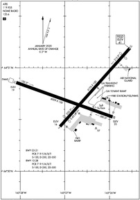
Runway 03/21
| Dimensions: | 6176 x 150 feet / 1882 x 46 meters | |
|---|---|---|
| Surface: | Asphalt / Grooved in Good Condition | |
| Weight Limits: | S-120, D-250, ST-550
PCR VALUE: 719/F/A/X/T
| |
| Edge Lighting: | Medium Intensity 30 IN ABV GND. | |
| Runway 03 | Runway 21 | |
| Coordinates: | N64°30.43' / W165°27.11' | N64°31.19' / W165°25.54' |
| Elevation: | 15.6 | 40.5 |
| Runway Heading: | 42° True | 222° True |
| Displaced Threshold: | 600 Feet | 601 Feet |
| Declared Distances: | TORA:6176 TODA:6176 ASDA:6176 LDA:5576 | TORA:5576 TODA:5576 ASDA:5576 LDA:5576 |
| Markings: | Non-Precision Instrument in good condition. | Non-Precision Instrument in good condition. |
| Glide Slope Indicator | P4L (3.00° Glide Path Angle) | P4L (3.00° Glide Path Angle) PAPI UNUSBL BYD 2 NM FM THR DUE TO RAPIDLY RISING TRRN. |
| REIL: | Yes | |
| Obstacles: | 37 ft Road 528 ft from runway, 336 ft left of center | 69 ft Pole 2150 ft from runway, 75 ft left of center |
Runway 10/28
| Dimensions: | 6009 x 150 feet / 1832 x 46 meters | |
|---|---|---|
| Surface: | Asphalt / Grooved in Good Condition | |
| Weight Limits: | S-150, D-250, ST-550
PCR VALUE: 719/F/A/X/T
| |
| Edge Lighting: | High Intensity 30 IN ABV GND. | |
| Runway 10 | Runway 28 | |
| Coordinates: | N64°30.86' / W165°28.09' | N64°30.53' / W165°25.93' |
| Elevation: | 19.3 | 24.8 |
| Runway Heading: | 110° True | 290° True |
| Declared Distances: | TORA:6009 TODA:6009 ASDA:6009 LDA:6009 | TORA:6009 TODA:6009 ASDA:6009 LDA:6009 |
| Markings: | Precision Instrument in good condition. | Precision Instrument in good condition. |
| Glide Slope Indicator | P4L (3.00° Glide Path Angle) | P4L (3.00° Glide Path Angle) |
| RVR Equipment | Rollout | Touchdown |
| Approach Lights: | MALSR 1,400 Foot Medium-intensity Approach Lighting System with runway alignment indicator lights. | |
| REIL: | Yes | |
| Obstacles: | 18 ft Hill 300 ft from runway, 250 ft right of center | 80 ft Hill 2500 ft from runway |
Services Available
| Fuel: | 100LL (blue), Jet-A, Jet A-1+ |
|---|---|
| Transient Storage: | Hangars |
| Airframe Repair: | MINOR |
| Engine Repair: | MINOR |
| Bottled Oxygen: | NOT AVAILABLE |
| Bulk Oxygen: | NOT AVAILABLE |
| Other Services: | CARGO HANDLING SERVICES |
Ownership Information
| Ownership: | Publicly owned | |
|---|---|---|
| Owner: | ALASKA DOT&PF NORTHERN REGION | |
| 2301 PEGER RD | ||
| FAIRBANKS, AK 99709 | ||
| 907-443-2500 | ||
| Manager: | GEORGE KOST | |
| BOX 1048 | ||
| NOME, AK 99762 | ||
| 907-443-2500 | ||
Other Remarks
- ARPT SAND LRGR GRADATION THAN FAA RCMDD/SEE AC150/5200-30.
- 130 FT LGTD WIND TURBINE TWRS 4 NM NNW.
- WX CAMERA AVBL ON INTERNET AT HTTPS://WEATHERCAMS.FAA.GOV
- TSA REG; SEE 49 CFR 1542. GATES & DOORS MUST BE SECURED H24. INFO - AMGR.
- AIRFIELD MAINT SVCS AVBL 0700 -1730; AFT HR - AMGR.
- ANG: AVN OPERG FAC - ANG HNGR 907-387-1800. OPS 1700-0100Z; LTD MAINT & SVCS AVBL.
- BIRDS INVOF ARPT SEP-OCT & MAY-JUN.
- RWY 21 & 28 ARR MNTN TFC PAT ALT TIL FNL.
- APCH SLOPE 26:1 DUE TO 35 FT ROAD 1128 FT FM DTHR.
- APCH SLOPE 34:1 DUE TO 69 FT POLE 1550 FT FM DTHR.
- 0LL AVBL HRS VRB - AFT HR AMGR.
- ACTVT MALSR RWY 28; REIL RWY 03 &10; PAPI RWY 03, 10, & 28; HIRL RWY 10/28; MIRL RWY 03/21 - CTAF. PAPI RWY 21 PAPI OPR CONSLY.
- ENGINEERED MATERIAL ARRESTING SYSTEM (EMAS) 200 FT IN LENGTH BY 170 FT IN WIDTH LCTD AT THE DER 28
Weather Minimums
Instrument Approach Procedure (IAP) Charts
Nearby Airports with Instrument Procedures
| ID | Name | Heading / Distance | ||
|---|---|---|---|---|
 |
PATE | Teller Airport | 332° | 49.4 |
 |
PAWM | White Mountain Airport | 077° | 53.6 |
 |
PFKT | Brevig Mission Airport | 332° | 55.8 |
 |
PAGL | Golovin Airport | 086° | 63.2 |
 |
PAIW | Wales Airport | 315° | 94.9 |
 |
PFKO | Kotlik Airport | 149° | 102.7 |
 |
PASH | Shishmaref Airport | 351° | 105.8 |
 |
PAEM | Emmonak Airport | 165° | 107.0 |
 |
PADE | Deering Airport | 034° | 115.4 |


