Login
Register
U56
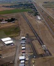
Rigby Airport
Official FAA Data Effective 2024-12-26 0901Z
VFR Chart of U56
Sectional Charts at SkyVector.com
IFR Chart of U56
Enroute Charts at SkyVector.com
Location Information for U56
Coordinates: N43°38.56' / W111°55.75'Located 02 miles S of Rigby, Idaho on 59 acres of land. View all Airports in Idaho.
Estimated Elevation is 4845 feet MSL.
Operations Data
|
|
Airport Communications
| CTAF: | 122.900 |
|---|---|
| ASOS at IDA (9.6 SW): | 208-524-4553 |
| ATIS at IDA (9.9 SW): | 135.325 |
| ASOS at RXE (12.5 NE): | 135.075 208-356-0986 |
Nearby Navigation Aids
|
| ||||||||||||||||||||||||||||||||||||||||||
Runway 01/19
| Dimensions: | 3727 x 50 feet / 1136 x 15 meters | |
|---|---|---|
| Surface: | Asphalt in Good Condition | |
| Edge Lighting: | Medium Intensity | |
| Runway 01 | Runway 19 | |
| Coordinates: | N43°38.28' / W111°55.90' | N43°38.85' / W111°55.60' |
| Traffic Pattern: | Left | Left |
| Displaced Threshold: | 225 Feet | |
| Markings: | Basic in good condition. | Basic in good condition. |
| Obstacles: | 5 ft Fence 270 ft from runway RWY 01 +5 FT FENCE AT 0 FT, 86 FT RIGHT. |
17 ft Road 275 ft from runway APCH SLOPE 29:1 TO DSPLCD THR. |
Services Available
| Fuel: | 100LL (blue) |
|---|---|
| Transient Storage: | Tiedowns |
| Airframe Repair: | NONE |
| Engine Repair: | NONE |
| Bottled Oxygen: | NONE |
| Bulk Oxygen: | NONE |
| Other Services: | CROP DUSTING SERVICES |
Ownership Information
| Ownership: | Publicly owned | |
|---|---|---|
| Owner: | CITY OF RIGBY | |
| P.O. BOX 275 | ||
| RIGBY, ID 83442 | ||
| 208-745-8111 | ||
| Manager: | BRUCE SPAULDING | |
| 230 N 4045 E | ||
| RIGBY, ID 83442 | ||
| (208) 716-3584 | ||
Other Remarks
- ONLY TWY EXITS LGTD W/BLUE LGTS.
- NOISE ABATEMENT PROCEDURES IN EFFECT. CALL AMGR 208-716-3584
- FOR CD CTC SALT LAKE ARTCC AT 801-320-2568.
- ACTVT MIRL RWY 01/19 - CTAF 122.9.
Nearby Airports with Instrument Procedures
| ID | Name | Heading / Distance | ||
|---|---|---|---|---|
 |
KIDA | Idaho Falls Regional Airport | 218° | 9.9 |
 |
KRXE | Rexburg-Madison County Airport | 025° | 12.7 |
 |
U02 | Mccarley Field Airport | 215° | 31.8 |
 |
KDIJ | Driggs/Reed Memorial Airport | 080° | 36.7 |
 |
KJAC | Jackson Hole Airport | 091° | 52.0 |
 |
KPIH | Pocatello Regional Airport | 213° | 52.8 |
 |
KAOC | Arco-Butte County Airport | 268° | 61.3 |
 |
KAFO | Afton Municipal Airport | 141° | 70.8 |
 |
KWYS | Yellowstone Airport | 028° | 71.9 |
 |
1U7 | Bear Lake County Airport | 162° | 87.5 |
 |
KEKS | Ennis Big Sky Airport | 006° | 98.7 |
 |
KDLN | Dillon Airport | 344° | 100.4 |


