Login
Register
GED
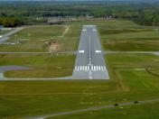
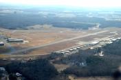
Delaware Coastal Airport
Official FAA Data Effective 2025-02-20 0901Z
VFR Chart of KGED
Sectional Charts at SkyVector.com
IFR Chart of KGED
Enroute Charts at SkyVector.com
Location Information for KGED
Coordinates: N38°41.26' / W75°21.56'Located 02 miles SE of Georgetown, Delaware on 663 acres of land. View all Airports in Delaware.
Surveyed Elevation is 53 feet MSL.
Operations Data
|
|
Airport Communications
| ASOS: | 118.375 Tel. 302-855-1052 |
|---|---|
| DOVER APPROACH: | 132.425 257.875 |
| DOVER DEPARTURE: | 132.425 257.875 |
| UNICOM: | 123.000 |
| CTAF: | 123.000 |
| ASOS at SBY (22.0 S): | 118.325 410-341-0868 |
| ASOS at OXB (25.3 SE): | 119.025 410-213-1530 |
| D-ATIS at DOV (27.0 N): | 127.825 |
Nearby Navigation Aids
|
| ||||||||||||||||||||||||||||||||||||||||||||||||||||||||||||
Runway 04/22
RWY 04/22 SUBJ TO FQT RWY ACFT BACKTAXI OPS. | ||
| Dimensions: | 5500 x 150 feet / 1676 x 46 meters | |
|---|---|---|
| Surface: | Asphalt / Grooved in Good Condition | |
| Weight Limits: | 43 /F/A/X/T, S-50, D-175 | |
| Edge Lighting: | Medium Intensity | |
| Runway 04 | Runway 22 | |
| Coordinates: | N38°40.97' / W75°21.95' | N38°41.73' / W75°21.32' |
| Elevation: | 48.9 | 48.5 |
| Traffic Pattern: | Left | Left |
| Runway Heading: | 33° True | 213° True |
| Displaced Threshold: | 370 Feet | 169 Feet |
| Markings: | Non-Precision Instrument in good condition. | Non-Precision Instrument in good condition. |
| Glide Slope Indicator | P4L (3.00° Glide Path Angle) | P4L (3.00° Glide Path Angle) |
| Approach Lights: | MALS 1,400 Foot Medium-intensity Approach Lighting System. | |
| REIL: | Yes | Yes |
| Obstacles: | 49 ft Trees 1258 ft from runway, 140 ft left of center | |
Runway 10/28
| Dimensions: | 3109 x 75 feet / 948 x 23 meters | |
|---|---|---|
| Surface: | Asphalt in Good Condition | |
| Weight Limits: | 36 /F/A/X/T, S-50, D-91 | |
| Edge Lighting: | Medium Intensity | |
| Runway 10 | Runway 28 | |
| Coordinates: | N38°41.09' / W75°21.75' | N38°41.09' / W75°21.10' |
| Elevation: | 49.0 | 53.3 |
| Runway Heading: | 90° True | 270° True |
| Markings: | Basic in good condition. | Basic in good condition. |
| Glide Slope Indicator | P2L (3.50° Glide Path Angle) | P2L (3.00° Glide Path Angle) |
| REIL: | Yes | Yes |
Services Available
| Fuel: | 100LL (blue), Jet-A |
|---|---|
| Transient Storage: | Tiedowns |
| Airframe Repair: | MAJOR |
| Engine Repair: | MAJOR |
| Bottled Oxygen: | NONE |
| Bulk Oxygen: | NOT AVAILABLE |
| Other Services: | AIR AMBULANCE SERVICES,CHARTER SERVICE,PILOT INSTRUCTION,AIRCRAFT RENTAL,AIRCRAFT SALES PARK & TIE DOWN FEES. |
Ownership Information
| Ownership: | Publicly owned | |
|---|---|---|
| Owner: | SUSSEX COUNTY COUNCIL | |
| PO BOX 589 | ||
| GEORGETOWN, DE 19947 | ||
| 302-855-7770 | ||
| Manager: | ROBERT L. BRYANT | ROBERT.BRYANT@SUSSEXCOUNTYDE.GOV. |
| 21553 RUDDER LANE | ||
| GEORGETOWN, DE 19947 | ||
| 302-855-7774 | ||
Other Remarks
- PAEW WITHIN SAFETY AREA OF RWYS & TWYS.
- BIRDS, DEER, AND OTHER WILDLIFE INVOF RWYS.
- FOR CD IF UNA VIA GCO FREQ, CTC DOVER APCH AT 302-677-3940. IF DOVER APCH UNA, CTC WASHINGTON ARTCC AT 703-771-3587.
- GCO AVBL ON FREQ 125.55.
- FBO HRS 0800-1800 LST. FOR SVC/FUEL AFT HRS CALL 302-855-2355.
- ACTVT MALS RWY 4; REIL RWY 04, 22, 10, 28; MIRL RWY 04/22 & 10/28 - CTAF.
- U.S. CUSTOMS 72 HRS NOTICE REQD CTC (302) 855-2355.
Weather Minimums
Instrument Approach Procedure (IAP) Charts
Departure Procedure (DP) Charts
Nearby Airports with Instrument Procedures
| ID | Name | Heading / Distance | ||
|---|---|---|---|---|
 |
N06 | Laurel Airport | 231° | 14.1 |
 |
KSBY | Salisbury-Ocean City Wicomico Regional Airport | 198° | 22.0 |
 |
KOXB | Ocean City Municipal Airport | 153° | 25.2 |
 |
KDOV | Dover AFB Airport | 349° | 27.0 |
 |
KWWD | Cape May County Airport | 047° | 28.6 |
 |
KRJD | Gooden Airpark Airport | 305° | 29.2 |
 |
KCGE | Cambridge-Dorchester Regional Airport | 254° | 32.8 |
 |
33N | Delaware Airpark Airport | 340° | 33.8 |
 |
KESN | Easton/Newnam Field Airport | 282° | 34.0 |
 |
KOBI | Woodbine Municipal Airport | 039° | 41.4 |
 |
KMIV | Millville Municipal Airport | 018° | 42.9 |
 |
KWAL | Wallops Flight Facility Airport | 186° | 45.1 |


