Login
Register
CYCW
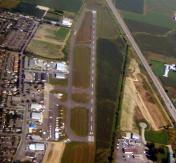
Chilliwack Airport
VFR Chart of CYCW
Sectional Charts at SkyVector.com
IFR Chart of CYCW
Enroute Charts at SkyVector.com
Location Information for CYCW
Coordinates: N49°9.20' / W121°56.35'View all Airports in British Columbia, Canada.
Elevation is 32 feet MSL.
Magnetic Variation from 2012 is 17° East
Time Zone is UTC-8(7).
Operations Data
|
|
Airport Communications
| Mandatory Frequency (MF) | traffic 122.7 3NM 2000 ASL (CAR 602.98) |
|---|---|
| AUTO | 122.975 |
Nearby Navigation Aids
|
| ||||||||||||||||||||||||||||||||||||||||||||||||||||||||||||
Runway 07/25
| Dimensions: | 3986 x 75 feet. | |
|---|---|---|
| Surface: | ||
| Remarks | ASPH Depression in rwy aprx 1000´ fr Thld 25. | |
| Runway 07 | Runway 25 | |
| Runway Heading: | 066° | 246° |
| Glide Slope Indicator | APAPI - Abbreviated PAPI for aircraft with eye-to-wheel height up to 10 feet. | APAPI - Abbreviated PAPI for aircraft with eye-to-wheel height up to 10 feet. |
Runway Conditions Reporting Source
Operator Ltd win maint. PLR
Services Available
| Fuel Available | 100LL, JA (Cardlock) JA-1 (by truck) 604-991-0078 1430-2330Z Mon-Fri exc hols, O/T call out chg |
|---|---|
| Servicing Available | Storage, Minor Repairs, Major Repairs, Extended Parking, Tie Downs, Plug-in |
Public Facilities
| Location | Facilities | Remarks |
|---|---|---|
| In Terminal Building | Food | (15-03Z),7 |
| Within 5 NM | Taxi, Medical Aid, Accomodations, Car Rental | (17-01Z) |
Flight Planning
| Flight Information Centre (FIC) | Kamloops 866-WXBRIEF (Toll free within Canada) or 866-541-4101 (Toll free within Canada & USA) |
|---|---|
| Weather (WX) | AUTO H24 (see COMM) |
Aerodrome Operator
Magnum Management Inc
604-792-3430 Cert
Nearby Airports with Instrument Procedures
| ID | Name | Heading / Distance | ||
|---|---|---|---|---|
 |
CYXX | Abbotsford Airport | 228° | 18.3 |
 |
KBLI | Bellingham International Airport | 210° | 32.1 |
 |
KBVS | Skagit Regional Airport | 188° | 45.2 |
 |
KORS | Orcas Island Airport | 218° | 46.8 |
 |
CYVR | Vancouver International Airport | 256° | 49.1 |
 |
KNUW | Whidbey Island NAS (Ault Field) Airport | 193° | 55.9 |
 |
KFHR | Friday Harbor Airport | 212° | 57.3 |
 |
CYDC | Princeton Airport | 053° | 59.1 |
 |
KAWO | Arlington Municipal Airport | 171° | 60.2 |
 |
KOKH | Delaurentis Airport | 191° | 61.5 |
 |
CYYJ | Victoria International Airport | 226° | 66.2 |
 |
KPAE | Seattle Paine Field International Airport | 173° | 76.1 |


