Login
Register
4S2
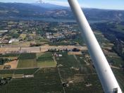
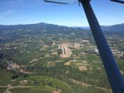
Ken Jernstedt Airfield Airport
Official FAA Data Effective 2025-12-25 0901Z
VFR Chart of 4S2
Sectional Charts at SkyVector.com
IFR Chart of 4S2
Enroute Charts at SkyVector.com
Location Information for 4S2
Coordinates: N45°40.37' / W121°32.03'Located 02 miles S of Hood River, Oregon on 120 acres of land. View all Airports in Oregon.
Surveyed Elevation is 638 feet MSL.
Operations Data
|
|
Airport Communications
| AWOS-3: | 134.375 Tel. 541-386-2386 |
|---|---|
| UNICOM: | 122.800 |
| CTAF: | 122.800 |
| ASOS at DLS (15.7 E): | 135.175 509-767-1726 |
| ASOS at TTD (37.2 W): | 135.625 503-492-2887 |
| ATIS at TTD (37.2 W): | 135.625 |
- COMMUNICATIONS PRVDD BY MCMINNVILLE RADIO ON FREQ 122.3 (HOOD RIVER RCO).
Nearby Navigation Aids
|
| ||||||||||||||||||||||||||||||||||||||||||||||||
Runway 07/25
GLIDERS AND ULTRALIGHTS USE RIGHT TFC. ALT GRASS LNDG AREA AVBL IN MEDIAN, NOT TO BE USED SIMULTANEOUSLY WITH PAVED RWY. | ||
| Dimensions: | 3040 x 75 feet / 927 x 23 meters | |
|---|---|---|
| Surface: | Asphalt in Excellent Condition | |
| Weight Limits: | S-23 | |
| Edge Lighting: | Medium Intensity | |
| Runway 07 | Runway 25 | |
| Coordinates: | N45°40.37' / W121°32.39' | N45°40.37' / W121°31.67' |
| Elevation: | 631.1 | 597.3 |
| Traffic Pattern: | Left | Left |
| Runway Heading: | 90° True | 270° True |
| Markings: | Basic in good condition. | Basic in good condition. |
| REIL: | Yes | |
| Obstacles: | 86 ft Tree 1514 ft from runway, 225 ft right of center | 50 ft Tree 980 ft from runway, 140 ft right of center |
Services Available
| Fuel: | 100LL (blue) |
|---|---|
| Transient Storage: | Tiedowns |
| Airframe Repair: | MAJOR |
| Engine Repair: | MAJOR |
| Bottled Oxygen: | NONE |
| Bulk Oxygen: | NONE |
| Other Services: | CROP DUSTING SERVICES,GLIDER SERVICE,PILOT INSTRUCTION,AIRCRAFT RENTAL,GLIDER TOWING SERVICES |
Ownership Information
| Ownership: | Publicly owned | |
|---|---|---|
| Owner: | PORT OF HOOD RIVER | |
| 1000 E. PORT MARINA DRIVE | ||
| HOOD RIVER, OR 97031 | ||
| 541-386-1645 | ||
| Manager: | JEFF RENARD | |
| 1000 E. PORT MARINA DRIVE | ||
| HOOD RIVER, OR 97031 | ||
| 509-767-2272 | ||
Other Remarks
- FREQUENT VEHICULAR TFC AER 7.
- BLUE EXIT LGTS AT 3 TURNOFFS.
- FOR CD CTC SEATTLE ARTCC AT 253-351-3694.
- HOOD RIVER ARPT IS A NOISE SENS AREA. PLS FLW THE FLY FRIENDLY SIGNS AT RWY ENDS AND AVOID LOW FLT.
- ACTVT MIRL RY 07/25; REIL RWY 25 - CTAF.
Nearby Airports with Instrument Procedures
| ID | Name | Heading / Distance | ||
|---|---|---|---|---|
 |
KDLS | Columbia Gorge Regional/The Dalles Municipal Airport | 101° | 15.7 |
 |
KTTD | Portland-Troutdale Airport | 258° | 37.3 |
 |
KPDX | Portland International Airport | 263° | 45.0 |
 |
KVUO | Pearson Field Airport | 266° | 47.4 |
 |
KSPB | Scappoose Airport | 276° | 56.1 |
 |
KUAO | Aurora State Airport | 244° | 58.1 |
 |
KHIO | Portland-Hillsboro Airport | 263° | 60.2 |
 |
S33 | Madras Municipal Airport | 164° | 62.3 |
 |
KKLS | Southwest Washington Regional Airport | 295° | 63.1 |
 |
KYKM | Yakima Air Trml/Mcallister Field Airport | 037° | 67.8 |
 |
KTDO | Ed Carlson Memorial Field/South Lewis County Airport | 312° | 71.8 |
 |
KMMV | Mc Minnville Municipal Airport | 247° | 73.5 |


