Login
Register


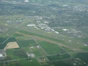
HIO
Portland-Hillsboro Airport
Official FAA Data Effective 2025-01-23 0901Z
From the Flight Deck
Chart Supplement

KHIO Airport Diagram

VFR Chart of KHIO
Sectional Charts at SkyVector.com
IFR Chart of KHIO
Enroute Charts at SkyVector.com
Location Information for KHIO
Coordinates: N45°32.53' / W122°57.04'Located 15 miles SW of Portland, Oregon on 900 acres of land. View all Airports in Oregon.
Surveyed Elevation is 207 feet MSL.
TPA: 1000 FT AGL, TURBINE AND LARGE AIRCRAFT 1500 FT AGL.
Operations Data
|
|
Airport Communications
| ATIS: | 127.65 |
|---|---|
| ASOS: | Tel. 503-615-4314 |
| HILLSBORO TOWER: | 119.3 132.8 239.3 |
| HILLSBORO GROUND: | 121.7 |
| PORTLAND APPROACH: | 118.1 ;HIGH 126.0 ;LOW 269.175 ;LOW 284.6 ;HIGH |
| PORTLAND DEPARTURE: | 118.1 ;HIGH 126.0 ;LOW 269.175 ;LOW 284.6 ;HIGH |
| CTAF: | 119.300 |
| HELNS STAR: | 124.35 299.2 |
| UNICOM: | 122.950 |
| OCITY STAR: | 124.35 299.2 |
| ASOS at VUO (13.2 E): | 135.125 360-696-1280 |
| ASOS at SPB (14.2 N): | 135.875 503-543-6401 |
| D-ATIS at PDX (15.1 E): | 128.35 |
- FREQ 121.5 NOT AVBL.
Nearby Navigation Aids
|
| ||||||||||||||||||||||||||||||||||||||||||||||||


Runway 13R/31L
| Dimensions: | 6600 x 150 feet / 2012 x 46 meters | |
|---|---|---|
| Surface: | Asphalt in Good Condition | |
| Weight Limits: | S-50, D-70, ST-110 | |
| Edge Lighting: | High Intensity | |
| Runway 13R | Runway 31L | |
| Coordinates: | N45°32.98' / W122°57.57' | N45°32.10' / W122°56.65' |
| Elevation: | 199.9 | 198.0 |
| Traffic Pattern: | Left | Left |
| Runway Heading: | 143° True | 323° True |
| Markings: | Precision Instrument in good condition. | Non-Precision Instrument in good condition. |
| Glide Slope Indicator | P4L (3.00° Glide Path Angle) | P4L (3.00° Glide Path Angle) |
| RVR Equipment | Touchdown | |
| Approach Lights: | MALSR 1,400 Foot Medium-intensity Approach Lighting System with runway alignment indicator lights. | |
| REIL: | Yes | |
| Obstacles: | 135 ft Tree 2800 ft from runway, 200 ft right of center | |
Runway 02/20
CLSD TO TOUCH AND GO LNDGS BETWEEN 2200-0600. | ||
| Dimensions: | 3820 x 75 feet / 1164 x 23 meters | |
|---|---|---|
| Surface: | Asphalt in Good Condition | |
| Weight Limits: | 20 /F/C/X/T, S-54, D-74, ST-139 | |
| Edge Lighting: | Medium Intensity | |
| Runway 02 | Runway 20 | |
| Coordinates: | N45°32.04' / W122°57.12' | N45°32.53' / W122°56.55' |
| Elevation: | 204.3 | 207.9 |
| Traffic Pattern: | Right | Left |
| Runway Heading: | 39° True | 219° True |
| Markings: | Basic in fair condition. | Basic in fair condition. |
| Glide Slope Indicator | P4R (3.00° Glide Path Angle) | P4L (3.00° Glide Path Angle) |
| Obstacles: | 15 ft Road 1370 ft from runway, 270 ft right of center | 72 ft Tree 2105 ft from runway, 450 ft left of center |
Runway 13L/31R
| Dimensions: | 3600 x 60 feet / 1097 x 18 meters | |
|---|---|---|
| Surface: | Asphalt in Excellent Condition | |
| Weight Limits: | 10 /F/D/Y/T, S-28 | |
| Edge Lighting: | Medium Intensity | |
| Runway 13L | Runway 31R | |
| Coordinates: | N45°33.00' / W122°57.39' | N45°32.52' / W122°56.89' |
| Elevation: | 200.6 | 206.1 |
| Traffic Pattern: | Right | |
| Runway Heading: | 144° True | 324° True |
| Markings: | Basic in good condition. | Basic in good condition. |
| Glide Slope Indicator | P4L (3.00° Glide Path Angle) UNUSBL BEYOND 8 DEG L AND R OF RWY CNTRLN | P4L (3.00° Glide Path Angle) UNUSBL BEYOND 8 DEG L AND R OF RWY CNTRLN |
Services Available
| Fuel: | 100LL (blue), Jet-A |
|---|---|
| Transient Storage: | Hangars,Tiedowns |
| Airframe Repair: | MAJOR |
| Engine Repair: | MAJOR |
| Bottled Oxygen: | LOW |
| Bulk Oxygen: | HIGH/LOW |
| Other Services: | AIR FREIGHT SERVICES,AIR AMBULANCE SERVICES,AVIONICS,CHARTER SERVICE,PILOT INSTRUCTION,AIRCRAFT RENTAL,AIRCRAFT SALES |
Ownership Information
| Ownership: | Publicly owned | |
|---|---|---|
| Owner: | THE PORT OF PORTLAND | |
| BOX 3529 | ||
| PORTLAND, OR 97208 | ||
| 503-944-7000 | ||
| Manager: | STEPHEN M. NAGY | |
| THE PORT OF PORTLAND, BOX 3529 | ||
| PORTLAND, OR 97208 | ||
| 503-460-4119 | ||
Other Remarks
- BE ALERT FOR BIRD ACTIVITY IN VICINITY NOV-MAY.
- NIGHTTIME TOUCH AND GOES ARE DISCOURAGED 0600-1400Z++.
- RWY 2-20 HAS 150' X 75' PAVED BLAST PADS AT BOTH ENDS
- RWY 13R-31L HAS 200' X 150' PAVED BLAST PADS AT BOTH ENDS
- GLIDER OPS 5NM NORTHWEST DURING DALGT HOURS MAR-OCT
- BE ALERT EXTV HELICOPTER TRAINING OPERATIONS TO TWY A, TWY B, TWY D.
- FOR CD WHEN TWR CLSD CTC PORTLAND APCH AT 503-493-7545.
- CSTMS AVBL 2000-0400Z++ 503-693-1069, OTHERWISE CSTMS FLT NOTIFICATION SVC (ADCUS) AVBL; ADVANCE COORDINATION REQ 503-326-3230.
- NOISE ABATEMENT PROCEDURES IN EFFECT CALL 503-460-4100 OR 800-938-6647.
- RY 13R RUN-UP AREA NOT VISIBLE FROM ATCT.
- RY 31L IS PREFERRED RY FOR NOISE ABATEMENT.
- NOISE SENSITIVE AREAS BORDER ARPT WEST, SOUTH AND EAST.
- FEE-BASED CSTMS FACILITY: $60 SINGLE-ENGINE, $175 TWIN-ENGINE, $500 TURBINE.
- AVOID LOW-LEVEL OVERFLIGHTS OF RESIDENTIAL AREAS WHENEVER POSSIBLE.
- WHEN ATCT CLSD ACTVT MALSR RWY 13R; PAPI RWY 02 & PAPI RWY 20 - CTAF.
- TPA: 1000 FT AGL, TURBINE AND LARGE AIRCRAFT 1500 FT AGL.
Weather Minimums
Standard Terminal Arrival (STAR) Charts


Instrument Approach Procedure (IAP) Charts


Departure Procedure (DP) Charts


Nearby Airports with Instrument Procedures
| ID | Name | Heading / Distance | ||
|---|---|---|---|---|
 |
KVUO | Pearson Field Airport | 069° | 13.3 |
|
KSPB | Scappoose Airport | 015° | 14.2 |
|
KPDX | Portland International Airport | 079° | 15.2 |
|
KUAO | Aurora State Airport | 156° | 19.3 |
|
KMMV | Mc Minnville Municipal Airport | 200° | 22.3 |
|
KTTD | Portland-Troutdale Airport | 088° | 23.2 |
|
KKLS | Southwest Washington Regional Airport | 003° | 34.6 |
|
KTMK | Tillamook Airport | 258° | 37.2 |
|
KSLE | Mcnary Field Airport | 183° | 38.0 |
|
KAST | Astoria Regional Airport | 313° | 53.7 |
|
S12 | Albany Municipal Airport | 184° | 54.5 |
|
KTDO | Ed Carlson Memorial Field/South Lewis County Airport | 006° | 56.4 |