Login
Register
53KT
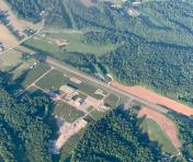
Liberty-Casey County Airport
Official FAA Data Effective 2026-02-19 0901Z
VFR Chart of 53KT
Sectional Charts at SkyVector.com
IFR Chart of 53KT
Enroute Charts at SkyVector.com
Location Information for 53KT
Coordinates: N37°18.51' / W85°3.55'Located 07 miles W of Liberty, Kentucky on 11 acres of land. View all Airports in Kentucky.
Surveyed Elevation is 1040 feet MSL.
Operations Data
|
|
Airport Communications
| AWOS-3 at AAS (12.3 W): | 121.125 270-789-1985 |
|---|---|
| AWOS-3P at K24 (18.1 S): | 119.6 270-343-5556 |
| AWOS-3 at DVK (21.2 NE): | 128.325 859-854-0058 |
Nearby Navigation Aids
|
| ||||||||||||||||||||||||||||||||||||||||||||||||||||||||||||
Runway 01/19
| Dimensions: | 3000 x 60 feet / 914 x 18 meters | |
|---|---|---|
| Surface: | Asphalt in Good Condition | |
| Runway 01 | Runway 19 | |
| Coordinates: | N37°18.27' / W85°3.61' | N37°18.75' / W85°3.48' |
| Traffic Pattern: | Left | Left |
| Markings: | Basic in good condition. | Basic in good condition. |
| Obstacles: | 74 ft Trees 367 ft from runway, 100 ft right of center 10 FT GROUND AND TREES 0-200 FT FROM RY END, 100 FT RIGHT. |
16 ft Road 201 ft from runway, 100 ft right of center +16 FT ARPT ROAD 0-200 FT FROM RY END, 100 FT RIGHT. |
Services Available
| Fuel: | NONE |
|---|---|
| Transient Storage: | Tiedowns |
| Airframe Repair: | NONE |
| Engine Repair: | NONE |
| Bottled Oxygen: | NONE |
| Bulk Oxygen: | NONE |
Ownership Information
| Ownership: | Publicly owned | |
|---|---|---|
| Owner: | CASEY CO ARPT BOARD | |
| PO BOX 306 | ||
| LIBERTY, KY 42539 | ||
| 606-787-6154 | ||
| Manager: | JACK PREWITT | ARPT BOARD CHMN. |
| 500 LAKETOWER DRIVE, UNIT 66 | ||
| LEXINGTON, KY 40502 | ||
| 606-303-3573 | ||
Other Remarks
- RWY 01 LGTD & MRKD RDO TWR 310' VCNTY OF RWY.
- EVIDENCE OF VEHICULAR TFC ON AIR OPS AREAS.
- VFR OPNS DALGT ONLY.
- MULTICOM - 122.900
- FOR CD CTC INDIANAPOLIS ARTCC AT 317-247-2411.
Nearby Airports with Instrument Procedures
| ID | Name | Heading / Distance | ||
|---|---|---|---|---|
 |
KAAS | Taylor County Airport | 284° | 12.3 |
 |
K24 | Russell County Airport | 186° | 18.0 |
 |
KDVK | Stuart Powell Field Airport | 040° | 21.2 |
 |
6I2 | Lebanon Springfield/George Hoerter Field Airport | 335° | 21.3 |
 |
KSME | Lake Cumberland Regional Airport | 125° | 26.2 |
 |
KEKQ | Wayne County Airport | 160° | 28.9 |
 |
KBRY | Samuels Field Airport | 325° | 36.9 |
 |
KRGA | Central Kentucky Regional Airport | 060° | 39.7 |
 |
KTZV | Tompkinsville/Monroe County Airport | 219° | 44.9 |
 |
KGLW | Glasgow Municipal Airport | 249° | 46.0 |
 |
KEKX | Addington Field Airport | 298° | 47.1 |
 |
KLEX | Blue Grass Airport | 026° | 48.6 |


