Login
Register
58VA
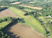
Walnut Hill Airport
Official FAA Data Effective 2024-12-26 0901Z
VFR Chart of 58VA
Sectional Charts at SkyVector.com
IFR Chart of 58VA
Enroute Charts at SkyVector.com
Location Information for 58VA
Coordinates: N38°35.71' / W77°38.77'Located 03 miles SE of Calverton, Virginia on 5 acres of land. View all Airports in Virginia.
Estimated Elevation is 285 feet MSL.
Operations Data
|
|
Airport Communications
| AWOS-3 at HWY (3.3 W): | 120.350 540-788-4078 |
|---|---|
| ATIS at HEF (9.7 NE): | 125.175 |
| AWOS-3PT at HEF (9.8 NE): | 703-361-6160 |
Nearby Navigation Aids
|
| ||||||||||||||||||||||||||||||||||||||||||||||||||||||||||||
Runway 18/36
| Dimensions: | 2490 x 50 feet / 759 x 15 meters | |
|---|---|---|
| Surface: | Turf | |
| Runway 18 | Runway 36 | |
| Displaced Threshold: | 500 Feet | 200 Feet |
| Obstacles: | 40 ft Trees 70 ft from runway | 70 ft Trees 600 ft from runway |
Ownership Information
| Ownership: | Privately Owned | |
|---|---|---|
| Owner: | WALNUT HILL FARM LLC | |
| 10593 SHENANDOAH PATH | ||
| CATLETT, VA 20119 | ||
| 540-788-4452 | ||
| Manager: | JANICE L. WILEY | |
| 10593 SHENANDOAH PATH | ||
| CATLETT, VA 22019 | ||
| 540-788-4452 | ||
Other Remarks
- (A40) CONES OUTLINE LANDING AREA.
- FOR CD CTC POTOMAC APCH AT 866-709-4993.
Nearby Airports with Instrument Procedures
| ID | Name | Heading / Distance | ||
|---|---|---|---|---|
 |
KHWY | Warrenton/Fauquier Airport | 260° | 3.1 |
 |
KHEF | Manassas Regional/Harry P Davis Field Airport | 039° | 9.7 |
 |
KCJR | Culpeper Regional Airport | 247° | 10.9 |
 |
KRMN | Stafford Regional Airport | 142° | 14.8 |
 |
KNYG | Quantico Mcaf (Turner Field) Airport | 108° | 17.0 |
 |
KEZF | Shannon Airport | 154° | 21.8 |
 |
KIAD | Washington Dulles International Airport | 022° | 22.9 |
 |
KDAA | Davison AAF Airport | 071° | 23.0 |
 |
2W5 | Maryland Airport | 089° | 27.0 |
 |
KOMH | Orange County Airport | 222° | 28.1 |
 |
KJYO | Leesburg Exec Airport | 008° | 29.2 |
 |
KDCA | Ronald Reagan Washington Ntl Airport | 061° | 32.4 |


