Login
Register
74N
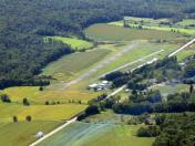
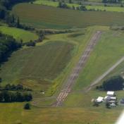
Bendigo Airport
Official FAA Data Effective 2025-11-27 0901Z
VFR Chart of 74N
Sectional Charts at SkyVector.com
IFR Chart of 74N
Enroute Charts at SkyVector.com
Location Information for 74N
Coordinates: N40°33.54' / W76°33.58'Located 02 miles S of Tower City, Pennsylvania on 41 acres of land. View all Airports in Pennsylvania.
Estimated Elevation is 790 feet MSL.
Operations Data
|
|
Airport Communications
| HARRISBURG APPROACH: | 126.45 269.45 |
|---|---|
| HARRISBURG DEPARTURE: | 126.45 269.45 |
| CTAF: | 122.900 |
| ASOS at MUI (7.3 S): | 124.175 717-861-6493 |
| AWOS-3 at ZER (12.4 NE): | 127.575 570-544-2778 |
| AWOS-2 at 9D4 (16.2 SE): | 118.45 717-866-2906 |
Nearby Navigation Aids
|
| ||||||||||||||||||||||||||||||||||||||||||||||||||||||
Runway 05/23
| Dimensions: | 2325 x 60 feet / 709 x 18 meters | |
|---|---|---|
| Surface: | Asphalt-Concrete in Good Condition | |
| Weight Limits: | S-12 | |
| Edge Lighting: | Medium Intensity | |
| Runway 05 | Runway 23 | |
| Coordinates: | N40°33.40' / W76°33.75' | N40°33.68' / W76°33.41' |
| Elevation: | 785.6 | 790.6 |
| Traffic Pattern: | Left | Left |
| Runway Heading: | 42° True | 222° True |
| Displaced Threshold: | 181 Feet | |
| Markings: | Basic in good condition. | Non-Precision Instrument in good condition. |
| Glide Slope Indicator | V2R (3.00° Glide Path Angle) VASI OTS INDEFLY. | |
| Obstacles: | 31 ft Trees 710 ft from runway, 12 ft right of center | 22 ft Tree 441 ft from runway, 135 ft left of center APCH RATIO 29:1 TO DTHR. |
Services Available
| Fuel: | NONE |
|---|---|
| Transient Storage: | Tiedowns |
| Airframe Repair: | NOT AVAILABLE |
| Engine Repair: | NOT AVAILABLE |
| Bottled Oxygen: | NONE |
| Bulk Oxygen: | NONE |
Ownership Information
| Ownership: | Privately Owned | |
|---|---|---|
| Owner: | GENE BENDIGO & HELEN BENDIGO TRUST | |
| 11079 CLARKS VALLEY RD | ||
| TOWER CITY, PA 17980 | ||
| 610-413-7428 | ||
| Manager: | PAUL BENDIGO | |
| 250 DICKINSON DR. | ||
| READING, PA 17605 | ||
| 610-413-7428 | ||
Other Remarks
- 160 FT LGHTD TWR 400 FT N OF RWY MIDFIELD.
- RAPIDLY RISING TRRN 1500 MSL N-NW OF RWY 5. MT RIDGE 1500 MSL 1 NM S OF ARPT PARALLEL TO RWY 5/23.
- FOR CD CTC HARRISBURG APCH AT 800-932-0712.
- DEER AND WILDLIFE ON & INVOF ARPT.
- CLSD DLY SS-SR.
- ACTVT MIRL RWY 05/23 - CTAF.
Weather Minimums
Instrument Approach Procedure (IAP) Charts
Nearby Airports with Instrument Procedures
| ID | Name | Heading / Distance | ||
|---|---|---|---|---|
 |
KZER | Schuylkill County/Joe Zerbey Airport | 043° | 12.3 |
 |
9D4 | Deck Airport | 139° | 16.3 |
 |
58N | Reigle Field Airport | 182° | 16.3 |
 |
N79 | Northumberland County Airport | 001° | 16.7 |
 |
08N | Keller Brothers Airport | 146° | 19.2 |
 |
KSEG | Penn Valley Airport | 318° | 21.0 |
 |
8N8 | Danville Airport | 350° | 23.7 |
 |
KMDT | Harrisburg International Airport | 203° | 23.8 |
 |
KCXY | Capital City Airport | 213° | 24.5 |
 |
N13 | Bloomsburg Municipal Airport | 012° | 26.9 |
 |
N71 | Donegal Springs Airpark Airport | 181° | 28.0 |
 |
KLNS | Lancaster Airport | 154° | 28.9 |


