Login
Register
C59
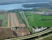
Lake Lawn Airport
Official FAA Data Effective 2026-01-22 0901Z
VFR Chart of C59
Sectional Charts at SkyVector.com
IFR Chart of C59
Enroute Charts at SkyVector.com
Location Information for C59
Coordinates: N42°38.05' / W88°36.07'Located 02 miles E of Delavan, Wisconsin on 40 acres of land. View all Airports in Wisconsin.
Estimated Elevation is 981 feet MSL.
Operations Data
|
|
Airport Communications
| ROCKFORD APPROACH: | 121.0 327.0 |
|---|---|
| ROCKFORD DEPARTURE: | 121.0 327.0 |
| CTAF: | 122.900 |
| AWOS-3 at BUU (13.5 E): | 125.275 262-757-0907 |
| AWOS-3PT at 57C (14.3 NE): | 118.125 262-642-1845 |
| ATIS at JVL (19.5 W): | 128.25 |
Nearby Navigation Aids
|
| ||||||||||||||||||||||||||||||||||||||||||||||||
Runway 18/36
| Dimensions: | 4423 x 80 feet / 1348 x 24 meters | |
|---|---|---|
| Surface: | Asphalt in Fair Condition | |
| Runway 18 | Runway 36 | |
| Coordinates: | N42°38.41' / W88°36.03' | N42°37.69' / W88°36.11' |
| Elevation: | 979.0 | 967.0 |
| Traffic Pattern: | Left | Left |
| Runway Heading: | 185° True | 5° True |
| Displaced Threshold: | 320 Feet | 300 Feet |
| Markings: | Non-Precision Instrument in poor condition. | Non-Precision Instrument in poor condition. |
| Obstacles: | 17 ft Tree 242 ft from runway, 120 ft right of center APCH RATIO 20:1 TO DSPLCD THR. 4 FT FENCE 12 FT FM RWY END; RD 40 FT FM RWY END. |
31 ft Tree 465 ft from runway, 34 ft right of center APCH RATIO 20:1 TO DSPLCD THR. 4 FT FENCE 5 FT FM RWY END; RD 30 FT FM RWY END. |
Services Available
| Fuel: | NONE |
|---|---|
| Transient Storage: | Tiedowns |
| Airframe Repair: | NONE |
| Engine Repair: | NONE |
| Bottled Oxygen: | NONE |
| Bulk Oxygen: | NONE |
Ownership Information
| Ownership: | Privately Owned | |
|---|---|---|
| Owner: | DELEVAN LAKE LAWN MANAGEMENT | |
| 2400 EAST GENEVA ST | ||
| DELAVAN, WI 53115 | ||
| 262-728-7950 | ||
| Manager: | DANIEL LYNG | |
| 2400 EAST GENEVA ST | ||
| DELAVAN, WI 53115 | ||
| (262) 725-9127 | ||
Other Remarks
- ARPT CLSD FOR NIGHT OPNS.
- LOW WING ACFT AVOID SOUTH TWY, 25 FT FM TWY CENTERLINE TO 3 FT FENCE.
- FOR CD CTC CHICAGO ARTCC AT 630-906-8921.
- MARKINGS FADED.
- MARKINGS FADED.
Nearby Airports with Instrument Procedures
| ID | Name | Heading / Distance | ||
|---|---|---|---|---|
 |
KBUU | Burlington Municipal Airport | 075° | 13.6 |
 |
57C | East Troy Municipal Airport | 045° | 14.1 |
 |
10C | Galt Field Airport | 144° | 17.1 |
 |
44C | Beloit Airport | 243° | 18.2 |
 |
KJVL | Southern Wisconsin Regional Airport | 267° | 19.5 |
 |
C77 | Poplar Grove Airport | 209° | 21.4 |
 |
61C | Fort Atkinson Municipal Airport | 334° | 21.9 |
 |
3CK | Lake In The Hills Airport | 154° | 28.5 |
 |
KUES | Waukesha County Airport | 033° | 29.2 |
 |
C81 | Campbell Airport | 128° | 29.9 |
 |
KENW | Kenosha Regional Airport | 094° | 29.9 |
 |
KRYV | Watertown Municipal Airport | 350° | 32.6 |


