Login
Register


DXR
Danbury Municipal Airport
Official FAA Data Effective 2026-01-22 0901Z
From the Flight Deck
Chart Supplement

KDXR Airport Diagram

VFR Chart of KDXR
Sectional Charts at SkyVector.com
IFR Chart of KDXR
Enroute Charts at SkyVector.com
Location Information for KDXR
Coordinates: N41°22.29' / W73°28.93'Located 03 miles SW of Danbury, Connecticut on 248 acres of land. View all Airports in Connecticut.
Surveyed Elevation is 456 feet MSL.
1743 FT AGL TURBOPROP/JET.
Operations Data
|
|
Airport Communications
| ATIS: | 127.75 |
|---|---|
| ASOS: | 127.75 Tel. 203-791-8227 |
| DANBURY TOWER: | 119.4 |
| DANBURY GROUND: | 121.6 |
| NEW YORK APPROACH: | 126.4 257.65 |
| NEW YORK DEPARTURE: | 126.4 257.65 |
| CLEARANCE DELIVERY: | 128.6 ;WHEN DXR TWR CLSD |
| NOBBI STAR: | 120.8 263.0 |
| UNICOM: | 122.950 |
| CTAF: | 119.400 |
| VALRE STAR: | 120.8 126.4 257.65 |
| AWOS-3PT at OXC (16.8 E): | 132.975 203-262-1190 |
| ATIS at OXC (16.9 E): | 132.975 |
| ASOS at BDR (20.3 SE): | 119.15 203-381-9453 |
Nearby Navigation Aids
|
| ||||||||||||||||||||||||||||||||||||||||||||||||||||||||||||


Runway 08/26
| Dimensions: | 4421 x 150 feet / 1348 x 46 meters | |
|---|---|---|
| Surface: | Asphalt / Grooved in Good Condition | |
| Weight Limits: | S-38, D-70 | |
| Edge Lighting: | Medium Intensity | |
| Runway 08 | Runway 26 | |
| Coordinates: | N41°22.12' / W73°29.45' | N41°22.37' / W73°28.54' |
| Elevation: | 456.6 | 453.1 |
| Traffic Pattern: | Left | Left |
| Runway Heading: | 70° True | 250° True |
| Displaced Threshold: | 367 Feet | 734 Feet |
| Markings: | Non-Precision Instrument in good condition. | Non-Precision Instrument in good condition. |
| REIL: | Yes | Yes |
| Obstacles: | 15 ft Trees 230 ft from runway, 75 ft left of center APCH RATIO 12:1 BASED ON DSPLCD THR. +9 FT FENCE 170 FT FM THR. |
88 ft Trees 450 ft from runway, 100 ft right of center APCH RATIO 11:1 TO DSPLCD THR. +6 FT FENCE 75 FT FM THR. |
Runway 17/35
RWY CLSD NGTS. | ||
| Dimensions: | 3135 x 100 feet / 956 x 30 meters | |
|---|---|---|
| Surface: | Asphalt in Good Condition | |
| Weight Limits: | S-50, D-65 | |
| Runway 17 | Runway 35 | |
| Coordinates: | N41°22.58' / W73°29.00' | N41°22.12' / W73°28.69' |
| Elevation: | 451.5 | 453.3 |
| Traffic Pattern: | Left | Left |
| Runway Heading: | 153° True | 333° True |
| Displaced Threshold: | 223 Feet | 231 Feet |
| Markings: | Basic in good condition. | Basic in good condition. |
| Obstacles: | 22 ft Pole 600 ft from runway, 150 ft left of center APCH RATIO 28:1 TO DSPLCD THR. 5 FT FENCE 50 FT FM THR; +15 FT ROAD 94 FT FM THR. |
30 ft Trees 350 ft from runway, 100 ft right of center APCH RATIO 19:1 TO DSPLCD THR. +8 FT FENCE 150 FT FM THR; +17 FT ROAD 120 FT FM THR. |
Services Available
| Fuel: | 100LL (blue), Jet-A |
|---|---|
| Transient Storage: | Hangars,Tiedowns |
| Airframe Repair: | MAJOR |
| Engine Repair: | MAJOR |
| Bottled Oxygen: | LOW |
| Bulk Oxygen: | NONE |
| Other Services: | AIR FREIGHT SERVICES,AVIONICS,CHARTER SERVICE,PILOT INSTRUCTION,AIRCRAFT RENTAL,AIRCRAFT SALES,ANNUAL SURVEYING |
Ownership Information
| Ownership: | Publicly owned | |
|---|---|---|
| Owner: | CITY OF DANBURY | |
| CITY HALL, 115 DEER HILL DR. | ||
| DANBURY, CT 06810 | ||
| 203-797-4624 | ||
| Manager: | MICHAEL SAFRANEK | |
| P.O.BOX 2299 | ||
| DANBURY, CT 06813 | ||
| 203-797-4624 | ||
Other Remarks
- ACFT USING RWY 35 ARE NOT VSB FM TWR DESCENDING BLW 1300 FT ON BASE LEG TIL APCHG 1/2 MI FINAL DUE TO NATURAL TRRN.
- PROHIBITED TO ULTRALIGHT & UNREGISTERED ACFT.
- COND UNMNT 1630-0730 MON-FRI & WKENDS.
- DEER & BIRDS ON & INVOF ARPT.
- INTXN TKOFS, STOP & GO TKOFS NOT AUZD.
- PPR FOR FRMN TKOF/LDG; CTC AMGR.
- NOISE ABATEMENT PROCS IN EFCT, RWY 17, SR-SS. DEPG RWY 17, EXTD RWY HDG BYD LAKE WAUBEEKA COMMUNITY BFR TURNING CROSSWIND.
- WHEN ATCT CLSD, ACTVT REIL RWY 08 & 26; MIRL RWY 08/26 - CTAF.
- 1743 FT AGL TURBOPROP/JET.
Weather Minimums

Standard Terminal Arrival (STAR) Charts
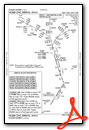
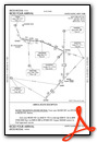

Instrument Approach Procedure (IAP) Charts


Nearby Airports with Instrument Procedures
| ID | Name | Heading / Distance | ||
|---|---|---|---|---|
 |
KOXC | Waterbury-Oxford Airport | 067° | 16.9 |
|
KBDR | Bridgeport/Sikorsky Airport | 127° | 20.4 |
|
KHPN | Westchester County Airport | 209° | 20.9 |
|
44N | Sky Acres Airport | 330° | 23.2 |
|
KPOU | Hudson Valley Regional Airport | 310° | 23.7 |
|
KHVN | Tweed/New Haven Airport | 103° | 27.6 |
|
KSWF | New York Stewart International Airport | 286° | 29.2 |
|
KMMK | Meriden Markham Municipal Airport | 074° | 30.6 |
|
4B8 | Robertson Field Airport | 055° | 33.7 |
|
KMGJ | Orange County Airport | 283° | 36.2 |
|
KISP | Long Island Mac Arthur Airport | 153° | 38.6 |
|
KFRG | Republic Airport | 175° | 38.6 |


