Login
Register


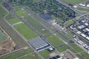
LVK
Livermore Municipal Airport
Official FAA Data Effective 2025-11-27 0901Z
From the Flight Deck
Chart Supplement

KLVK Airport Diagram

VFR Chart of KLVK
Sectional Charts at SkyVector.com
IFR Chart of KLVK
Enroute Charts at SkyVector.com
Location Information for KLVK
Coordinates: N37°41.60' / W121°49.22'Located 03 miles W of Livermore, California on 644 acres of land. View all Airports in California.
Surveyed Elevation is 399 feet MSL.
Operations Data
|
|
Airport Communications
| ATIS: | 119.65 ((925) 447-9516) |
|---|---|
| ASOS: | Tel. 925-606-5412 |
| LIVERMORE TOWER: | 118.1 239.25 |
| LIVERMORE GROUND: | 121.6 |
| NORCAL APPROACH: | 123.85 ;RWY 07L/25R, 07R/25L 278.3 ;RWY 07L/25R, 07R/25L |
| NORCAL DEPARTURE: | 123.85 ;RWY 07L, 07R 125.35 ;RWY 25L, 25R 278.3 ;RWY 07L, 07R 354.1 ;RWY 25L, 25R |
| CTAF: | 118.100 |
| UNICOM: | 122.950 |
| AWOS-3 at C83 (12.3 NE): | 123.775 925-634-0906 |
| ASOS at HWD (14.4 W): | 510-786-3052 |
| ATIS at HWD (14.5 W): | 126.7 |
- FREQ 121.5 NOT AVAILABLE.
Nearby Navigation Aids
|
| ||||||||||||||||||||||||||||||||||||


Runway 07L/25R
| Dimensions: | 5253 x 100 feet / 1601 x 30 meters | |
|---|---|---|
| Surface: | Asphalt / Grooved in Excellent Condition | |
| Weight Limits: | S-45, D-90 | |
| Edge Lighting: | High Intensity RWY EDGE LGT ON LOW AND MED INTST LEVEL ON DOWNWIND LEG OF TFC PAT DFCLT TO SEE. | |
| Runway 07L | Runway 25R | |
| Coordinates: | N37°41.64' / W121°49.76' | N37°41.63' / W121°48.68' |
| Elevation: | 372.9 | 399.9 |
| Traffic Pattern: | Right | |
| Runway Heading: | 90° True | 270° True |
| Markings: | Precision Instrument in good condition. | Precision Instrument in good condition. |
| Glide Slope Indicator | P4R (4.00° Glide Path Angle) | P4L (3.00° Glide Path Angle) |
| Approach Lights: | MALSR 1,400 Foot Medium-intensity Approach Lighting System with runway alignment indicator lights. | |
| Obstacles: | 75 ft Tree 2016 ft from runway, 350 ft left of center +6 FT FENCE 180 FT FM RY END 400 FT LEFT OF EXTDD CNTRLN. |
24 ft Building 638 ft from runway, 560 ft right of center |
Runway 07R/25L
| Dimensions: | 2699 x 75 feet / 823 x 23 meters | |
|---|---|---|
| Surface: | Asphalt in Excellent Condition | |
| Weight Limits: | S-12 | |
| Edge Lighting: | Medium Intensity | |
| Runway 07R | Runway 25L | |
| Coordinates: | N37°41.55' / W121°49.51' | N37°41.55' / W121°48.95' |
| Elevation: | 378.8 | 394.6 |
| Traffic Pattern: | Right | |
| Runway Heading: | 90° True | 270° True |
| Markings: | Basic in good condition. | Basic in good condition. |
Helipad H1
| Dimensions: | 24 x 22 feet / 7 x 7 meters | |
|---|---|---|
| Surface: | Asphalt in Good Condition | |
| Coordinates: | N37°41.44' / W121°49.40' | N0°0.00' / E0°0.00' |
| Elevation: | 382.0 | |
Services Available
| Fuel: | 100LL (blue), Jet-A |
|---|---|
| Transient Storage: | Tiedowns |
| Airframe Repair: | MAJOR |
| Engine Repair: | MAJOR |
| Bottled Oxygen: | HIGH |
| Bulk Oxygen: | HIGH |
| Other Services: | AVIONICS,CHARTER SERVICE,PILOT INSTRUCTION,AIRCRAFT RENTAL,AIRCRAFT SALES |
Ownership Information
| Ownership: | Publicly owned | |
|---|---|---|
| Owner: | CITY OF LIVERMORE | |
| 1052 SOUTH LIVERMORE AVE | ||
| LIVERMORE, CA 94550 | ||
| 925-960-4200 | ||
| Manager: | BENEDICT STUTH | |
| 680 TERMINAL CIRCLE | ||
| LIVERMORE, CA 94551 | ||
| 925-960-8230 | ||
Other Remarks
- BE ALERT TO CONSIDERABLE BIRD ACTIVITY ON & IN VICINITY OF ARPT.
- DO NOT MISTAKE PARALLEL TAXIWAY N OF RWY 25R/7L AS RWY. NOISE SENSITIVE AREAS 3/4 MILE EAST & 2 MILES W OF ARPT.
- EFFECTIVE RY GRADIENT RY 07L 0.52% UP; RY 07R 0.59% UP.
- FOR CD WHEN ATCT IS CLSD CTC NORCAL APCH AT 916-361-0516.
- PLS OBS "VOLUNTARY RESTRAINT FROM NIGHT FLYING 2200L-0600L POLICY."
- ATC CNTL. WHEN ATCT CLSD, ACTVT MALSR RWY 25R; TWY LGTS - 118.1. HIRL RWY 07L/25R OPER LOW INTST; TO INCREASE INTST ACTVT 118.1. MIRL RWY 07R/25L OPER LOW INTST; NOT AVBL WHEN ATCT CLSD. PAPI RWY 07L AND 25R OPR CONSLY.
Weather Minimums

Instrument Approach Procedure (IAP) Charts


Departure Procedure Obstacles (DPO) Charts


Nearby Airports with Instrument Procedures
| ID | Name | Heading / Distance | ||
|---|---|---|---|---|
 |
C83 | Byron Airport | 048° | 12.3 |
|
KHWD | Hayward Exec Airport | 261° | 14.5 |
|
KTCY | Tracy Municipal Airport | 090° | 18.0 |
|
KOAK | Oakland San Francisco Bay Airport | 275° | 19.2 |
|
KPAO | Palo Alto Airport | 225° | 19.8 |
|
KNUQ | Moffett Federal Airfield Airport | 213° | 19.9 |
|
KSJC | Norman Y Mineta San Jose International Airport | 194° | 20.5 |
|
KCCR | Buchanan Field Airport | 327° | 21.0 |
|
KRHV | Reid-Hillview of Santa Clara County Airport | 179° | 21.6 |
|
KSQL | San Carlos Airport | 242° | 23.2 |
|
KSFO | San Francisco International Airport | 260° | 26.8 |
|
KSCK | Stockton Metro Airport | 066° | 30.2 |