Login
Register
N16
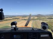
Centre Airpark Airport
Official FAA Data Effective 2026-01-22 0901Z
VFR Chart of N16
Sectional Charts at SkyVector.com
IFR Chart of N16
Enroute Charts at SkyVector.com
Location Information for N16
Coordinates: N40°48.70' / W77°39.43'Located 02 miles SE of Centre Hall, Pennsylvania on 14 acres of land. View all Airports in Pennsylvania.
Estimated Elevation is 1307 feet MSL.
Operations Data
|
|
Airport Communications
| UNICOM: | 122.700 |
|---|---|
| CTAF: | 122.700 |
| AWOS-3PT at RVL (8.2 S): | 123.85 717-667-3993 |
| D-ATIS at UNV (8.9 W): | 127.65 |
| AWOS-3 at UNV (9.0 W): | 127.65 814-865-8799 |
Nearby Navigation Aids
|
| ||||||||||||||||||||||||||||||||||||||||||||||||
Runway 06/24
| Dimensions: | 3100 x 210 feet / 945 x 64 meters | |
|---|---|---|
| Surface: | Turf in Good Condition | |
| Runway 06 | Runway 24 | |
| Traffic Pattern: | Left | Left |
| Displaced Threshold: | 400 Feet | 400 Feet |
| Obstacles: | 10 ft Road 5 ft from runway CTLNG OBSTN EXCEEDS 45 DEG SLP. |
52 ft Trees 611 ft from runway, 155 ft right of center APCH SLP 24:1 TO DTHR. |
Services Available
| Fuel: | NONE |
|---|---|
| Transient Storage: | Tiedowns |
| Airframe Repair: | NOT AVAILABLE |
| Engine Repair: | NOT AVAILABLE |
| Bottled Oxygen: | NONE |
| Bulk Oxygen: | NONE |
Ownership Information
| Ownership: | Privately Owned | |
|---|---|---|
| Owner: | JOE HENRY GARBRICK | |
| 386 AIRPORT ROAD | ||
| CENTRE HALL, PA 16828 | ||
| 814-364-1403 | ||
| Manager: | JOE HENRY GARBRICK | |
| 458 AIRPORT ROAD | ||
| CENTRE HALL, PA 16828 | ||
| (814) 364-9188 | ||
Other Remarks
- ULTRALIGHT ACTIVITY ON & INVOF ARPT.
- RY 06/24 NOT MAINTAINED WINTER MOS.
- RC AIRPLANE OPERATIONS ON & INVOF AIRPORT.
- FOR CD CTC NEW YORK ARTCC AT 631-468-1425.
- RWY 06 THR UNMKD. DTHR MKD AT 720 FT.
- RWY 24 THR UNMKD. DTHR MKD AT 610 FT.
Nearby Airports with Instrument Procedures
| ID | Name | Heading / Distance | ||
|---|---|---|---|---|
 |
KRVL | Mifflin County Airport | 170° | 8.2 |
 |
N96 | Bellefonte Airport | 301° | 8.5 |
 |
KUNV | State College Regional Airport | 284° | 9.0 |
 |
P34 | Mifflintown Airport | 137° | 17.2 |
 |
KPSB | Mid-State Airport | 282° | 20.1 |
 |
KLHV | William T Piper Memorial Airport | 028° | 22.2 |
 |
KSEG | Penn Valley Airport | 088° | 36.1 |
 |
KFIG | Clearfield-Lawrence Airport | 292° | 37.3 |
 |
KIPT | Williamsport Regional Airport | 052° | 42.2 |
 |
KAOO | Altoona/Blair County Airport | 224° | 43.3 |
 |
N94 | Carlisle Airport | 149° | 43.4 |
 |
8N8 | Danville Airport | 079° | 46.8 |


