Login
Register


SFM
Sanford Seacoast Regional Airport
Official FAA Data Effective 2026-02-19 0901Z
Chart Supplement

VFR Chart of KSFM
Sectional Charts at SkyVector.com
IFR Chart of KSFM
Enroute Charts at SkyVector.com
Location Information for KSFM
Coordinates: N43°23.63' / W70°42.48'Located 04 miles SE of Sanford, Maine on 1300 acres of land. View all Airports in Maine.
Surveyed Elevation is 244 feet MSL.
Operations Data
|
|
Airport Communications
| AWOS-3PT: | 120.025 Tel. 207-324-1958 |
|---|---|
| PORTLAND APPROACH: | 119.75 269.35 |
| PORTLAND DEPARTURE: | 119.75 269.35 |
| CLEARANCE DELIVERY: | 121.725 |
| CTAF: | 123.075 |
| UNICOM: | 123.075 |
| ASOS at DAW (11.7 SW): | 135.275 603-332-7814 |
| ATIS at PSM (19.6 S): | 273.5 |
| ASOS at PSM (20.1 S): |
- APCH/DEP SVC PRVDD BY BOSTON ARTCC ON FREQS 128.2/263.05 (WATERBORO RCAG) WHEN PORTLAND APCH CTL CLSD.
Nearby Navigation Aids
|
| ||||||||||||||||||||||||||||||||||||||||||||||||||||||||||||


Runway 07/25
| Dimensions: | 6389 x 100 feet / 1947 x 30 meters | |
|---|---|---|
| Surface: | Asphalt / Grooved in Good Condition | |
| Weight Limits: | S-65, D-100 | |
| Edge Lighting: | High Intensity | |
| Runway 07 | Runway 25 | |
| Coordinates: | N43°23.20' / W70°43.18' | N43°23.75' / W70°41.96' |
| Elevation: | 240.5 | 232.1 |
| Traffic Pattern: | Left | Left |
| Runway Heading: | 58° True | 238° True |
| Displaced Threshold: | 388 Feet | |
| Markings: | Precision Instrument in good condition. | Non-Precision Instrument in good condition. |
| Glide Slope Indicator | P4L (3.00° Glide Path Angle) | P4L (3.00° Glide Path Angle) |
| Approach Lights: | ODALS Omnidirectional Approach Lighting System | |
| REIL: | Yes | |
| Obstacles: | 30 ft Tree 1074 ft from runway, 278 ft left of center APCH RATIO 49:1 AT DTHR. |
18 ft Power Line 695 ft from runway, 460 ft right of center |
Runway 14/32
| Dimensions: | 4999 x 100 feet / 1524 x 30 meters | |
|---|---|---|
| Surface: | Asphalt in Good Condition | |
| Weight Limits: | D-72 | |
| Edge Lighting: | Medium Intensity | |
| Runway 14 | Runway 32 | |
| Coordinates: | N43°24.02' / W70°42.86' | N43°23.62' / W70°41.87' |
| Elevation: | 244.0 | 230.7 |
| Traffic Pattern: | Left | Left |
| Runway Heading: | 119° True | 299° True |
| Displaced Threshold: | 885 Feet | |
| Markings: | Basic in good condition. | Basic in good condition. |
| Glide Slope Indicator | P4L (4.00° Glide Path Angle) | P4L (3.00° Glide Path Angle) |
| Obstacles: | 68 ft Tree 516 ft from runway, 120 ft left of center APCH RATIO 20:1 AT DTHR. |
|
Services Available
| Fuel: | 100LL (blue), Jet-A, Automotive Gasoline |
|---|---|
| Transient Storage: | Hangars,Tiedowns |
| Airframe Repair: | MAJOR |
| Engine Repair: | MAJOR |
| Bottled Oxygen: | HIGH/LOW |
| Bulk Oxygen: | NONE |
| Other Services: | AIR AMBULANCE SERVICES,PILOT INSTRUCTION,AIRCRAFT RENTAL,ANNUAL SURVEYING |
Ownership Information
| Ownership: | Publicly owned | |
|---|---|---|
| Owner: | CITY OF SANFORD | |
| 919 MAIN ST | ||
| SANFORD, ME 04073 | ||
| (207) 324-9173 | ||
| Manager: | M. ALLISON NAVIA | |
| 9 PRESIDENTIAL LN | ||
| SANFORD, ME 04073 | ||
| 207-324-3172 | ||
Other Remarks
- WILDLIFE ON & INVOF ARPT.
- HIGH VOL FIXED AND ROTARY WING FLT TRNG IN VCNTY.
- CALM WIND PREFERRED RWY 32.
- 24 HR FUEL AVBL WITH MAJOR CREDIT CARD FOR 100LL, A & MOGAS.
- CONDS NOT MNT DLY 1600-0700 EST.
- FBO AFT HRS CALL-OUT FEE - 207-324-8919.
- FOR CD WHEN APCH CLSD CTC BOSTON ARTCC AT 603-879-6859.
- ACTVT ODALS RWY 25; REIL RWY 07; PAPI RWY 07 & 25; HIRL 07/25; MIRL 14/32; TWY LGTS - CTAF. TWY LGTS INOP DALGT HRS.
Weather Minimums

Instrument Approach Procedure (IAP) Charts


Nearby Airports with Instrument Procedures
| ID | Name | Heading / Distance | ||
|---|---|---|---|---|
 |
B19 | Biddeford Municipal Airport | 067° | 11.1 |
|
KDAW | Skyhaven Airport | 235° | 11.7 |
|
3B4 | Seacoast Airfield Airport | 190° | 15.3 |
|
KPSM | Portsmouth International At Pease Airport | 194° | 19.6 |
|
KPWM | Portland International Jetport Airport | 048° | 23.1 |
|
KLCI | Laconia Municipal Airport | 289° | 32.8 |
|
KCON | Concord Municipal Airport | 252° | 36.6 |
|
KIZG | White Mountain Regional Airport | 343° | 37.3 |
|
KMHT | Manchester Boston Regional Airport | 229° | 42.3 |
|
KLEW | Auburn/Lewiston Municipal Airport | 025° | 43.4 |
|
KLWM | Lawrence Municipal Airport | 204° | 44.5 |
|
KBXM | Brunswick Exec Airport | 047° | 44.9 |
Airport Images
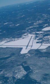
By: ChuckinMaine


