Login
Register


02C
Capitol Drive Airport
Official FAA Data Effective 2026-01-22 0901Z
Chart Supplement

VFR Chart of 02C
Sectional Charts at SkyVector.com
IFR Chart of 02C
Enroute Charts at SkyVector.com
Location Information for 02C
Coordinates: N43°5.38' / W88°10.77'Located 03 miles E of Brookfield, Wisconsin on 207 acres of land. View all Airports in Wisconsin.
Surveyed Elevation is 844 feet MSL.
Operations Data
|
|
Airport Communications
| UNICOM: | 122.700 |
|---|---|
| CTAF: | 122.700 |
| ATIS at UES (3.9 SW): | 118.875 |
| AWOS-3 at UES (3.9 SW): | 118.875 262-521-5226 |
| AWOS-3 at MWC (6.5 E): | 414-461-2954 |
Nearby Navigation Aids
|
| ||||||||||||||||||||||||||||||||||||||||||||||||


Runway 09/27
| Dimensions: | 3387 x 100 feet / 1032 x 30 meters | |
|---|---|---|
| Surface: | Turf in Fair Condition | |
| Runway 09 | Runway 27 | |
| Coordinates: | N43°5.41' / W88°11.14' | N43°5.44' / W88°10.38' |
| Elevation: | 832.4 | 826.4 |
| Traffic Pattern: | Left | Left |
| Markings: | None | None |
| Obstacles: | 30 ft Tree 140 ft from runway, 90 ft left of center | 82 ft Trees 1400 ft from runway |
Runway 03/21
| Dimensions: | 2994 x 45 feet / 913 x 14 meters | |
|---|---|---|
| Surface: | Asphalt in Fair Condition | |
| Edge Lighting: | Non-Standard DTHR LGTS G AND W, END OF PAVEMENT LGTS RED. | |
| Runway 03 | Runway 21 | |
| Coordinates: | N43°5.14' / W88°10.83' | N43°5.61' / W88°10.64' |
| Elevation: | 843.0 | 827.2 |
| Traffic Pattern: | Left | Left |
| Runway Heading: | 16° True | 196° True |
| Displaced Threshold: | 1378 Feet | 694 Feet |
| Markings: | Basic in poor condition. | Basic in poor condition. |
| Obstacles: | 10 ft Brush 200 ft from runway, 65 ft left of center APCH RATIO 20:1 TO DTHR. 10 FT BRUSH 0-200 FT FM RWY END; 120 - 60 FT L. |
8 ft Brush 200 ft from runway, 50 ft right of center APCH RATIO 20:1 TO DTHR. 10 FT BRUSH 0-200 FT FM RWY END; 50 FT L & 80 FT R. |
Runway 18/36
| Dimensions: | 1602 x 80 feet / 488 x 24 meters | |
|---|---|---|
| Surface: | Turf in Fair Condition | |
| Runway 18 | Runway 36 | |
| Coordinates: | N43°5.43' / W88°10.83' | N43°5.17' / W88°10.84' |
| Elevation: | 831.0 | 844.2 |
| Traffic Pattern: | Left | Left |
| Markings: | None | None |
| Obstacles: | 55 ft Tree 63 ft from runway, 124 ft right of center | 15 ft Brush 0 ft from runway, 120 ft left of center |
Services Available
| Fuel: | 100LL (blue), UL91 |
|---|---|
| Transient Storage: | Hangars,Tiedowns |
| Airframe Repair: | NONE |
| Engine Repair: | NONE |
| Bottled Oxygen: | NONE |
| Bulk Oxygen: | NONE |
| Other Services: | PILOT INSTRUCTION,AIRCRAFT RENTAL |
Ownership Information
| Ownership: | Privately Owned | |
|---|---|---|
| Owner: | WISCONSIN AVIATION INVESTMENTS LLC | |
| 4800 N. PINECREST DRIVE | ||
| CHENEQUA, WI 53058 | ||
| 262-391-0343 | ||
| Manager: | MATT BYRNE | |
| 21500 GUMINA DR | NINER614WHISKEY@YAHOO.COM. | |
| BROOKFIELD, WI 53072 | ||
| 262-781-4213 | ADNL FONE 414-406-3119. | |
Other Remarks
- RWY 03 & 36 ACFT OPS CANNOT SEE RWY 27 ACFT OPS.
- RWY 09/27 & 18/36 NOT PLOWED. DEC 1 THRU APR 15. OPEN FOR SKI EQUIPPED ACFT AND WHEELED ACFT WHEN GND FROZEN. CRM CONDS & SNOW REMOVAL FOR RWY 03/21 WITH AMGR.
- FOR CD CTC CHICAGO ARTCC AT 630-906-8921.
- MRKGS FADED.
- MKD WITH YELLOW CONES.
- MKD WITH WHITE AND BLACK BARRELS.
- MRKGS FADED.
- MKD WITH YELLOW CONES.
- MKD WITH YELLOW CONES.
- ACTVT MIRL RWY 03/21 - CTAF.
Nearby Airports with Instrument Procedures
| ID | Name | Heading / Distance | ||
|---|---|---|---|---|
 |
KUES | Waukesha County Airport | 221° | 3.9 |
|
KMWC | Lawrence J Timmerman Airport | 078° | 6.5 |
|
KMKE | General Mitchell International Airport | 124° | 15.1 |
|
KHXF | Hartford Municipal Airport | 329° | 18.2 |
|
57C | East Troy Municipal Airport | 205° | 19.5 |
|
KETB | West Bend Municipal Airport | 006° | 20.1 |
|
KRYV | Watertown Municipal Airport | 281° | 24.4 |
|
KBUU | Burlington Municipal Airport | 193° | 24.6 |
|
KRAC | Batten International Airport | 140° | 25.5 |
|
61C | Fort Atkinson Municipal Airport | 255° | 29.1 |
|
KUNU | Dodge County Airport | 311° | 30.6 |
|
KENW | Kenosha Regional Airport | 159° | 31.6 |
Airport Images
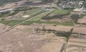
By: Big Orange Bird


Comments
I had unplanned landing at
313 Brothers, LLC
P:313-314-7135
e: 313brothers@protonmail.com