Login
Register


ENW
Kenosha Regional Airport
Official FAA Data Effective 2026-02-19 0901Z
From the Flight Deck
Chart Supplement

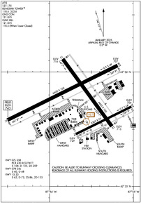
KENW Airport Diagram
VFR Chart of KENW
Sectional Charts at SkyVector.com
IFR Chart of KENW
Enroute Charts at SkyVector.com
Location Information for KENW
Coordinates: N42°35.76' / W87°55.64'Located 04 miles W of Kenosha, Wisconsin on 974 acres of land. View all Airports in Wisconsin.
Surveyed Elevation is 742 feet MSL.
Operations Data
|
|
Airport Communications
| ATIS: | 127.175 |
|---|---|
| ASOS: | Tel. 262-652-7730 |
| KENOSHA TOWER: | 118.6 353.6 |
| KENOSHA GROUND: | 121.875 |
| MILWAUKEE APPROACH: | 135.875 317.725 |
| MILWAUKEE DEPARTURE: | 135.875 317.725 |
| CLEARANCE DELIVERY: | 121.875 118.6 ;WHEN TWR CLSD |
| GOPAC STAR: | 126.5 307.0 |
| CTAF: | 118.600 |
| UNICOM: | 122.950 |
| ASOS at UGN (10.6 S): | 847-782-0876 |
| ATIS at UGN (10.8 S): | 132.4 |
| ASOS at RAC (11.1 NE): | 121.425 262-635-0959 |
Nearby Navigation Aids
|
| ||||||||||||||||||||||||||||||||||||||||||||||||||||||


Runway 07L/25R
| Dimensions: | 6600 x 100 feet / 2012 x 30 meters | |
|---|---|---|
| Surface: | Concrete / Grooved in Excellent Condition | |
| Weight Limits: | S-108, D-135, ST-209
PCR VALUE: 430/R/D/W/T
| |
| Edge Lighting: | High Intensity | |
| Runway 07L | Runway 25R | |
| Coordinates: | N42°35.58' / W87°56.50' | N42°36.06' / W87°55.18' |
| Elevation: | 742.6 | 707.2 |
| Traffic Pattern: | Right | |
| Runway Heading: | 64° True | 244° True |
| Markings: | Precision Instrument in good condition. | Precision Instrument in good condition. |
| Glide Slope Indicator | P4L (3.00° Glide Path Angle) | P4L (3.00° Glide Path Angle) |
| Approach Lights: | MALSR 1,400 Foot Medium-intensity Approach Lighting System with runway alignment indicator lights. | |
| REIL: | Yes | |
Runway 15/33
| Dimensions: | 4440 x 100 feet / 1353 x 30 meters | |
|---|---|---|
| Surface: | Asphalt / Grooved in Excellent Condition | |
| Weight Limits: | S-62, D-73, ST-135 | |
| Edge Lighting: | High Intensity | |
| Runway 15 | Runway 33 | |
| Coordinates: | N42°36.11' / W87°55.84' | N42°35.52' / W87°55.26' |
| Elevation: | 716.2 | 714.9 |
| Traffic Pattern: | Left | Left |
| Runway Heading: | 144° True | 324° True |
| Markings: | Non-Precision Instrument in good condition. | Non-Precision Instrument in good condition. |
| Glide Slope Indicator | V4L (4.00° Glide Path Angle) | V4L (3.00° Glide Path Angle) |
| Obstacles: | 58 ft Trees 1150 ft from runway, 270 ft left of center | |
Runway 07R/25L
CLSD TO JET ACFT & ACFT WEIGHING MORE THAN 12500 LBS WHEN RWY 07L/25R IS OPEN. | ||
| Dimensions: | 3302 x 75 feet / 1006 x 23 meters | |
|---|---|---|
| Surface: | Asphalt in Fair Condition | |
| Weight Limits: | S-40, D-48 | |
| Edge Lighting: | Medium Intensity | |
| Runway 07R | Runway 25L | |
| Coordinates: | N42°35.46' / W87°55.68' | N42°35.70' / W87°55.02' |
| Elevation: | 729.3 | 706.1 |
| Traffic Pattern: | Right | Left |
| Runway Heading: | 64° True | 244° True |
| Markings: | Basic in fair condition. | Basic in fair condition. |
| Glide Slope Indicator | P4L (3.00° Glide Path Angle) | P4L (3.00° Glide Path Angle) PAPI UNUSBL BYD 7 DEGS RIGHT OF CNTRLN. |
| Obstacles: | 34 ft Trees 850 ft from runway, 25 ft left of center | |
Services Available
| Fuel: | 100LL (blue), Jet A+ |
|---|---|
| Transient Storage: | Hangars,Tiedowns |
| Airframe Repair: | MAJOR |
| Engine Repair: | MAJOR |
| Bottled Oxygen: | NONE |
| Bulk Oxygen: | HIGH/LOW |
| Other Services: | AVIONICS,CARGO HANDLING SERVICES,CHARTER SERVICE,PILOT INSTRUCTION,AIRCRAFT RENTAL,AIRCRAFT SALES |
Ownership Information
| Ownership: | Publicly owned | |
|---|---|---|
| Owner: | CITY OF KENOSHA | |
| 625 52ND ST | ||
| KENOSHA, WI 53140 | ||
| (262) 653-4159 | ||
| Manager: | COREY REED | |
| 9900 52ND ST | ||
| KENOSHA, WI 53144 | ||
| 262-653-4161 | ||
Other Remarks
- BIRDS ON & INVOF ARPT.
- HELICOPTER DEP & ARR OPS WILL BE AUTH BY ATC FM MOVEMENT AREAS ONLY. NON-MOVEMENT AREA DEPS, ARRS & PRACTICE, ARE PROHIBITED.
- ACFT WEIGHING MORE THAN 122,000 LBS, EMPTY OR FULLY LOADED, ARE NOT ALLOWED TO BE BASED AT KENW. THE TERM BASED SHALL BE DEFINED AS AN ACFT THAT IS OPR & AIRWORTHY ON THE ARPT FOR A MAJORITY OF THE YEAR.
- WHEN ATCT CLSD, HIRL RWY 07L/25R PRESET ON LOW INTST; TO INCR INTST & ACTVT MALSR RWY 07L; REIL RWY 25R; PAPI RWY 07L, 07R, 25L & 25R; HIRL RWY 07L/25R; HIRL RWY 15/33; MIRL RWY 07R/25L - CTAF. VASI RWY 15 & 33 OPRS CONSLY.
Weather Minimums


Standard Terminal Arrival (STAR) Charts
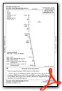
Instrument Approach Procedure (IAP) Charts


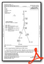
Departure Procedure (DP) Charts
Nearby Airports with Instrument Procedures
| ID | Name | Heading / Distance | ||
|---|---|---|---|---|
 |
KUGN | Waukegan Ntl Airport | 165° | 10.8 |
|
KRAC | Batten International Airport | 026° | 11.1 |
|
C81 | Campbell Airport | 201° | 17.5 |
|
KBUU | Burlington Municipal Airport | 288° | 17.6 |
|
C02 | Grand Geneva Resort Airport | 273° | 20.5 |
|
KMKE | General Mitchell International Airport | 003° | 21.1 |
|
10C | Galt Field Airport | 239° | 23.0 |
|
57C | East Troy Municipal Airport | 301° | 23.1 |
|
KPWK | Chicago Exec Airport | 177° | 28.9 |
|
3CK | Lake In The Hills Airport | 217° | 29.2 |
|
KUES | Waukesha County Airport | 332° | 30.0 |
|
KMWC | Lawrence J Timmerman Airport | 351° | 31.2 |
Fuel Providers

Airport Images
Do you have a recent image of this airport? Upload it here!


