Login
Register


07F
Gladewater Municipal Airport
Official FAA Data Effective 2026-02-19 0901Z
Chart Supplement

VFR Chart of 07F
Sectional Charts at SkyVector.com
IFR Chart of 07F
Enroute Charts at SkyVector.com
Location Information for 07F
Coordinates: N32°31.73' / W94°58.31'Located 02 miles SW of Gladewater, Texas on 146 acres of land. View all Airports in Texas.
Surveyed Elevation is 296 feet MSL.
Operations Data
|
|
Airport Communications
| LONGVIEW APPROACH: | 124.275 257.975 |
|---|---|
| LONGVIEW DEPARTURE: | 124.275 257.975 |
| CTAF: | 122.900 |
| AWOS-3PT at JXI (10.6 N): | 120.250 903-734-7313 |
| ATIS at GGG (15.8 SE): | 119.65 |
| ASOS at GGG (15.8 SE): | 903-643-4029 |
- APCH/DEP CTL SVC PRVDD BY FORT WORTH ARTCC (ZFW) ON FREQS 126.325/346.25 (SHREVEPORT RCAG) WHEN LONGVIEW APCH CTL (GGG) CLSD.
Nearby Navigation Aids
|
| ||||||||||||||||||||||||||||||||||||||||||||||||||||||||||||


Runway 14/32
| Dimensions: | 3299 x 75 feet / 1006 x 23 meters | |
|---|---|---|
| Surface: | Asphalt in Poor Condition | |
| Weight Limits: | S-12 | |
| Edge Lighting: | Medium Intensity | |
| Runway 14 | Runway 32 | |
| Coordinates: | N32°31.99' / W94°58.52' | N32°31.56' / W94°58.13' |
| Elevation: | 285.0 | 295.6 |
| Traffic Pattern: | Left | Left |
| Runway Heading: | 143° True | 323° True |
| Markings: | Non-Precision Instrument in good condition. | Non-Precision Instrument in good condition. |
| Glide Slope Indicator | P2L (3.00° Glide Path Angle) | |
| Obstacles: | 25 ft Trees 201 ft from runway, 130 ft right of center CONTROLLING OBSTRUCTION EXCEEDS A 45 DEGREE SLOPE 15 FT TREES, 0-199 FT DSTC, 84 FT R. |
85 ft Trees 1050 ft from runway, 415 ft right of center 12 FT TREES, 50 FT DSTC, 130 FT L. |
Runway 17/35
| Dimensions: | 2300 x 50 feet / 701 x 15 meters | |
|---|---|---|
| Surface: | Asphalt in Good Condition NMRS CRACKS, LOOSE STONES. | |
| Weight Limits: | S-7 | |
| Runway 17 | Runway 35 | |
| Coordinates: | N32°31.85' / W94°58.28' | N32°31.48' / W94°58.27' |
| Elevation: | 291.9 | 294.6 |
| Traffic Pattern: | Left | Left |
| Runway Heading: | 179° True | 359° True |
| Markings: | Basic in good condition. | Basic in good condition. |
| Obstacles: | 45 ft Trees 268 ft from runway, 125 ft left of center | 40 ft Trees 375 ft from runway, 55 ft left of center |
Services Available
| Fuel: | 100LL (blue) |
|---|---|
| Transient Storage: | Tiedowns |
| Airframe Repair: | NONE |
| Engine Repair: | NONE |
| Bottled Oxygen: | NONE |
| Bulk Oxygen: | NONE |
| Other Services: | PILOT INSTRUCTION,PARACHUTE JUMP ACTIVITY,AIRCRAFT RENTAL |
Ownership Information
| Ownership: | Publicly owned | |
|---|---|---|
| Owner: | CITY OF GLADEWATER | |
| 519 E BROADWAY AVE, PO BOX 1725 | ||
| GLADEWATER, TX 75647 | ||
| 903-845-2196 | ||
| Manager: | CHARLIE SMITH | |
| 519 E BROADWAY AVE, PO BOX 1725 | ||
| GLADEWATER, TX 75647 | ||
| 903-845-2586 | ||
Other Remarks
- FOR CD CTC FORT WORTH ARTCC AT 817-858-7584.
- ARPT PHYS ADDR 1300 US-271, GLADEWATER, TX
Weather Minimums

Instrument Approach Procedure (IAP) Charts


Nearby Airports with Instrument Procedures
| ID | Name | Heading / Distance | ||
|---|---|---|---|---|
 |
KJXI | Fox Stephens Field/Gilmer Municipal Airport | 006° | 10.2 |
|
KGGG | East Texas Regional Airport | 123° | 15.8 |
|
KRFI | Rusk County Airport | 165° | 24.0 |
|
KTYR | Tyler Pounds Regional Airport | 244° | 24.3 |
|
F51 | Winnsboro Municipal Airport | 327° | 29.1 |
|
KJDD | Wood County/Collins Field Airport | 295° | 29.5 |
|
KASL | Harrison County Airport | 090° | 33.7 |
|
KOSA | Mount Pleasant Regional Airport | 000° | 34.0 |
|
4F2 | Panola County-Sharpe Field Airport | 121° | 40.2 |
|
KJSO | Cherokee County Airport | 197° | 41.4 |
|
F53 | Franklin County Airport | 341° | 43.2 |
|
F44 | Athens Municipal Airport | 243° | 48.7 |
Airport Images
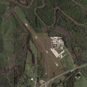
By: dsorrells


