Login
Register


JSO
Cherokee County Airport
Official FAA Data Effective 2025-12-25 0901Z
Chart Supplement

VFR Chart of KJSO
Sectional Charts at SkyVector.com
IFR Chart of KJSO
Enroute Charts at SkyVector.com
Location Information for KJSO
Coordinates: N31°52.16' / W95°13.04'Located 06 miles SE of Jacksonville, Texas on 224 acres of land. View all Airports in Texas.
Surveyed Elevation is 677 feet MSL.
Operations Data
|
|
Airport Communications
| AWOS-3: | 119.075 Tel. 903-586-0124 |
|---|---|
| LONGVIEW APPROACH: | 128.75 379.15 |
| LONGVIEW DEPARTURE: | 128.75 379.15 |
| UNICOM: | 122.700 |
| CTAF: | 122.700 |
| AWOS-3 at RFI (24.8 NE): | 119.375 903-657-0384 |
| AWOS-3PT at PSN (25.5 W): | 118.025 903-729-3641 |
| ATIS at TYR (30.6 N): | 126.25 |
- APCH/DEP SVC PRVDD BY FORT WORTH ARTCC (ZFW) ON FREQS 135.25/279.65 (TYLER RCAG) WHEN LONGVIEW APCH CLSD.
Nearby Navigation Aids
|
| ||||||||||||||||||||||||||||||||||||||||||||||||||||||||||||


Runway 14/32
| Dimensions: | 5006 x 75 feet / 1526 x 23 meters | |
|---|---|---|
| Surface: | Asphalt in Good Condition | |
| Weight Limits: | S-30 | |
| Edge Lighting: | Medium Intensity | |
| Runway 14 | Runway 32 | |
| Coordinates: | N31°52.48' / W95°13.35' | N31°51.84' / W95°12.73' |
| Elevation: | 677.6 | 657.7 |
| Traffic Pattern: | Left | Left |
| Runway Heading: | 140° True | 320° True |
| Markings: | Non-Precision Instrument in good condition. | Non-Precision Instrument in good condition. |
| Glide Slope Indicator | P4L (3.00° Glide Path Angle) | P4L (3.00° Glide Path Angle) |
| REIL: | Yes | |
| Obstacles: | 7 ft Trees 290 ft from runway, 226 ft left of center | ft Tree ft from runway |
Services Available
| Fuel: | 100LL (blue), Jet-A |
|---|---|
| Transient Storage: | Tiedowns |
| Airframe Repair: | MAJOR |
| Engine Repair: | MAJOR |
| Bottled Oxygen: | NONE |
| Bulk Oxygen: | NONE |
| Other Services: | PILOT INSTRUCTION,AIRCRAFT RENTAL,AIRCRAFT SALES |
Ownership Information
| Ownership: | Publicly owned | |
|---|---|---|
| Owner: | CHEROKEE COUNTY | |
| 135 S. MAIN 3RD FLOOR | ||
| RUSK, TX 75785 | ||
| 903-683-2324 | ||
| Manager: | RANDA WALKER-BYNUM | |
| 420 CR 1618 | ||
| RUSK, TX 75785 | ||
| 903-586-8219 | ||
Other Remarks
- FOR CD CTC FORT WORTH ARTCC AT 817-858-7584.
- 0LL 100LL 24 HR SELF-SERVE.
- JET A FULL SERVE 0800-1700 MON-SAT. SELF-SERVE 24/7.
- DUSK-DAWN, MIRL RWY 14/32 PRESET LOW INTST; TO INCR INTST AND TO ACTVT REIL RWY 14 - CTAF.
Weather Minimums
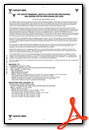
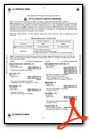
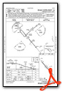
Instrument Approach Procedure (IAP) Charts


Nearby Airports with Instrument Procedures
| ID | Name | Heading / Distance | ||
|---|---|---|---|---|
 |
KRFI | Rusk County Airport | 048° | 24.8 |
|
KPSN | Palestine Municipal Airport | 258° | 25.6 |
|
KTYR | Tyler Pounds Regional Airport | 341° | 30.5 |
|
KOCH | Nacogdoches A L Mangham Jr Regional Airport | 123° | 31.3 |
|
KDKR | Houston County Airport | 195° | 35.0 |
|
F44 | Athens Municipal Airport | 299° | 35.8 |
|
KGGG | East Texas Regional Airport | 039° | 40.2 |
|
07F | Gladewater Municipal Airport | 017° | 41.4 |
|
KLFK | Angelina County Airport | 147° | 45.0 |
|
4F2 | Panola County-Sharpe Field Airport | 068° | 50.3 |
|
KJXI | Fox Stephens Field/Gilmer Municipal Airport | 015° | 51.5 |
|
F17 | Center Municipal Airport | 092° | 54.3 |
Airport Images

By: soneyjoseph


