Login
Register


0A4
Johnson City Airport
Official FAA Data Effective 2026-02-19 0901Z
Chart Supplement

VFR Chart of 0A4
Sectional Charts at SkyVector.com
IFR Chart of 0A4
Enroute Charts at SkyVector.com
Location Information for 0A4
Coordinates: N36°21.82' / W82°18.54'Located 03 miles NE of Johnson City, Tennessee on 45 acres of land. View all Airports in Tennessee.
Estimated Elevation is 1550 feet MSL.
Operations Data
|
|
Airport Communications
| CTAF: | 122.900 |
|---|---|
| AWOS-3PT at 0A9 (6.4 E): | 135.675 423-543-1801 |
| ASOS at TRI (8.2 NW): | 118.25 423-218-2712 |
| ATIS at TRI (8.2 NW): | 118.25 |
Nearby Navigation Aids
|
| ||||||||||||||||||||||||||||||||||||||||||||||||||||||||||||


Runway 04/22
DEP RWY 04; ARR RWY 22 RCMDD. | ||
| Dimensions: | 3000 x 50 feet / 914 x 15 meters | |
|---|---|---|
| Surface: | Asphalt in Poor Condition GRASS, CRACKING & OXIDIZED PAVEMENT. | |
| Weight Limits: | S-15 | |
| Runway 04 | Runway 22 | |
| Traffic Pattern: | Left | Left |
| Displaced Threshold: | 800 Feet | |
| Markings: | Basic in good condition. | Basic in good condition. |
Services Available
| Fuel: | NONE |
|---|---|
| Transient Storage: | Tiedowns |
| Airframe Repair: | NOT AVAILABLE |
| Engine Repair: | NOT AVAILABLE |
| Bottled Oxygen: | NOT AVAILABLE |
| Bulk Oxygen: | NOT AVAILABLE |
Ownership Information
| Ownership: | Privately Owned | |
|---|---|---|
| Owner: | GEORGE W ST JOHN, HEIRS | |
| RT 1 BOX 122 | ||
| WATAUGA, TN 37694 | ||
| (423) 928-4500 | ||
| Manager: | PRESTON ELDRED | |
| 209 CRESTWOOD DRIVE | ||
| JOHNSON CITY, TN 37601 | ||
| 423-928-4500 | ||
Other Remarks
- FOR CD CTC ATLANTA ARTCC AT 770-210-7692.
Nearby Airports with Instrument Procedures
| ID | Name | Heading / Distance | ||
|---|---|---|---|---|
 |
0A9 | William B Greene Jr Regional Airport | 085° | 6.6 |
|
KTRI | Tri-Cities Airport | 324° | 8.2 |
|
KVJI | Virginia Highlands Airport | 034° | 23.4 |
|
6A4 | Johnson County Airport | 081° | 23.7 |
|
KGCY | Greeneville Municipal Airport | 247° | 26.4 |
|
KRVN | Hawkins County Airport | 281° | 28.5 |
|
KLNP | Lonesome Pine Airport | 344° | 38.9 |
|
KGEV | Ashe County Airport | 084° | 43.3 |
|
KMRN | Foothills Regional Airport | 133° | 47.0 |
|
0VG | Lee County Airport | 291° | 47.3 |
|
KJFZ | Tazewell County Airport | 030° | 48.6 |
|
KMOR | Moore-Murrell Airport | 258° | 52.9 |
Airport Images
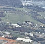
By: Big Orange Bird


