Login
Register
0VG
Lee County Airport
Official FAA Data Effective 2026-01-22 0901Z
VFR Chart of 0VG
Sectional Charts at SkyVector.com
IFR Chart of 0VG
Enroute Charts at SkyVector.com
Location Information for 0VG
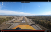
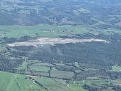
Coordinates: N36°39.25' / W83°13.07'Located 05 miles SW of Jonesville, Virginia on 328 acres of land. View all Airports in Virginia.
Surveyed Elevation is 1410 feet MSL.
Operations Data
|
|
Airport Communications
| AWOS-3: | 120.125 Tel. 276-346-3333 |
|---|---|
| CTAF: | 122.900 |
| AWOS-3 at I35 (14.0 NW): | 118.35 606-573-9104 |
| AWOS-3 at 1A6 (25.2 W): | 119.425 606-248-3095 |
| AWOS-3 at MOR (29.9 S): | 126.725 423-587-5886 |
- APCH/DEP SVC PRVDD BY ATLANTA ARTCC ON FREQS 127.55/269.50 (NEWPORT RCAG).
Nearby Navigation Aids
|
| ||||||||||||||||||||||||||||||||||||||||||||||||||||||||||||
Runway 07/25
| Dimensions: | 5003 x 75 feet / 1525 x 23 meters | |
|---|---|---|
| Surface: | Asphalt in Good Condition | |
| Weight Limits: | S-30 | |
| Edge Lighting: | Medium Intensity | |
| Runway 07 | Runway 25 | |
| Coordinates: | N36°39.04' / W83°13.51' | N36°39.45' / W83°12.63' |
| Elevation: | 1365.8 | 1410.9 |
| Runway Heading: | 60° True | 240° True |
| Markings: | Non-Precision Instrument in fair condition. | Non-Precision Instrument in fair condition. |
| Glide Slope Indicator | P4L (3.00° Glide Path Angle) | P4R (3.25° Glide Path Angle) |
| REIL: | Yes | Yes |
| Obstacles: | 67 ft Tree 2367 ft from runway, 477 ft left of center 3 FT TREE 108 FT FRM THLD, 198 FT L OF CNTRLN ON APCH. |
15 ft Tree 495 ft from runway, 201 ft left of center |
Services Available
| Fuel: | 100LL (blue), Jet A+ |
|---|---|
| Transient Storage: | Tiedowns |
| Airframe Repair: | NOT AVAILABLE |
| Engine Repair: | NOT AVAILABLE |
| Bottled Oxygen: | NOT AVAILABLE |
| Bulk Oxygen: | NOT AVAILABLE |
Ownership Information
| Ownership: | Publicly owned | |
|---|---|---|
| Owner: | LEE COUNTY, VIRGINIA | |
| PO BOX 367 | ||
| JONESVILLE, VA 24263 | ||
| 276-346-7714 | ||
| Manager: | ROB WRIGHT | COUNTY ADMINISTRATOR. |
| 33640 MAIN ST | ||
| JONESVILLE, VA 24263 | ||
| 276-346-7714 | ||
Other Remarks
- FOR CD CTC ATLANTA ARTCC AT 770-210-7692.
- ACTVT REIL RWY 07 & 25; PAPI RWY 07 & 25; MIRL RWY 07/25 - CTAF.
Weather Minimums
Instrument Approach Procedure (IAP) Charts
Nearby Airports with Instrument Procedures
| ID | Name | Heading / Distance | ||
|---|---|---|---|---|
 |
I35 | Tucker-Guthrie Memorial Airport | 331° | 14.0 |
 |
KRVN | Hawkins County Airport | 126° | 19.9 |
 |
3A2 | New Tazewell Municipal Airport | 228° | 22.0 |
 |
1A6 | Middlesboro/Bell County Airport | 264° | 25.2 |
 |
KMOR | Moore-Murrell Airport | 195° | 29.4 |
 |
KGCY | Greeneville Municipal Airport | 144° | 33.8 |
 |
KLNP | Lonesome Pine Airport | 058° | 38.7 |
 |
KTRI | Tri-Cities Airport | 105° | 40.6 |
 |
KCPF | Wendell H Ford Airport | 357° | 44.0 |
 |
KBYL | Williamsburg-Whitley County Airport | 280° | 48.1 |
 |
KLOZ | London/Corbin/Magee Airport | 302° | 48.8 |
 |
KJAU | Colonel Tommy C Stiner Airfield Airport | 247° | 49.6 |


