Login
Register


6A4
Johnson County Airport
Official FAA Data Effective 2026-02-19 0901Z
Chart Supplement

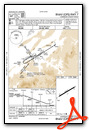
VFR Chart of 6A4
Sectional Charts at SkyVector.com
IFR Chart of 6A4
Enroute Charts at SkyVector.com
Location Information for 6A4
Coordinates: N36°25.07' / W81°49.51'Located 04 miles S of Mountain City, Tennessee on 73 acres of land. View all Airports in Tennessee.
Estimated Elevation is 2241 feet MSL.
Operations Data
|
|
Airport Communications
| AWOS-3: | 126.225 Tel. 423-727-4365 |
|---|---|
| TRI CITY APPROACH: | 134.425 349.0 |
| TRI CITY DEPARTURE: | 134.425 349.0 |
| CTAF: | 122.700 |
| UNICOM: | 122.700 |
| AWOS-3PT at TNB (15.6 SE): | 119.250 828-268-8921 |
| AWOS-3PT at 0A9 (17.2 W): | 135.675 423-543-1801 |
| AWOS-3 at VJI (19.1 NW): | 128.125 276-628-2940 |
- APCH/DEP SVC PRVDD BY ATLANTA ARTCC ON FREQS 125.15/263.0 (HICKORY RCAG) WHEN TRI-CITIES RGNL APCH CLSD.
Nearby Navigation Aids
|
| ||||||||||||||||||||||||||||||||||||||||||||||||||||||||||||


Runway 07/25
| Dimensions: | 4498 x 75 feet / 1371 x 23 meters | |
|---|---|---|
| Surface: | Asphalt in Good Condition | |
| Weight Limits: | D-26, ST-37 | |
| Edge Lighting: | Medium Intensity | |
| Runway 07 | Runway 25 | |
| Coordinates: | N36°24.88' / W81°49.90' | N36°25.27' / W81°49.12' |
| Elevation: | 2240.3 | 2241.1 |
| Traffic Pattern: | Right | Left |
| Runway Heading: | 58° True | 238° True |
| Markings: | Non-Precision Instrument in good condition. | Non-Precision Instrument in good condition. |
| Glide Slope Indicator | P2L (3.00° Glide Path Angle) | P2L (3.00° Glide Path Angle) |
| Obstacles: | 34 ft Tree 784 ft from runway, 193 ft left of center | 97 ft Tree 1797 ft from runway, 423 ft right of center |
Services Available
| Fuel: | 100LL (blue), Jet A+ |
|---|---|
| Transient Storage: | Hangars,Tiedowns |
| Airframe Repair: | MAJOR |
| Engine Repair: | MAJOR |
| Bottled Oxygen: | NOT AVAILABLE |
| Bulk Oxygen: | NOT AVAILABLE |
| Other Services: | AVIONICS,GLIDER SERVICE,PILOT INSTRUCTION,PARACHUTE JUMP ACTIVITY,AIRCRAFT RENTAL DYNON ONLY. |
Ownership Information
| Ownership: | Publicly owned | |
|---|---|---|
| Owner: | JOHNSON COUNTY | |
| CO COURTHSE; 222 W MAIN ST | ||
| MOUNTAIN CITY, TN 37683 | ||
| 423-727-9696 | ||
| Manager: | DAVE GARRIS | |
| 611 AIRPORT ROAD | ||
| MOUNTAIN CITY, TN 37683 | ||
| 423-727-1223 | ||
Other Remarks
- MT TRRN & HIGH PEAKS ALL QUADS; TSNT NIGHT OPS NOT RCMDD.
- DEER & BIRDS INVOF ARPT.
- COLD TEMPERATURE AIRPORT. ALTITUDE CORRECTION REQUIRED AT OR BELOW -9C.
- FOR CD CTC ATLANTA ARTCC AT 770-210-7692.
- ACTVT MIRL RWY 07/25 - CTAF.
Weather Minimums

Instrument Approach Procedure (IAP) Charts

Nearby Airports with Instrument Procedures
| ID | Name | Heading / Distance | ||
|---|---|---|---|---|
 |
0A9 | William B Greene Jr Regional Airport | 260° | 17.1 |
|
KVJI | Virginia Highlands Airport | 327° | 19.0 |
|
KGEV | Ashe County Airport | 087° | 19.7 |
|
KTRI | Tri-Cities Airport | 277° | 28.4 |
|
KMKJ | Mountain Empire Airport | 038° | 36.6 |
|
KUKF | Wilkes County Airport | 108° | 37.1 |
|
KMRN | Foothills Regional Airport | 163° | 37.3 |
|
KJFZ | Tazewell County Airport | 001° | 38.7 |
|
KHKY | Hickory Regional Airport | 152° | 45.7 |
|
KLNP | Lonesome Pine Airport | 315° | 48.2 |
|
KGCY | Greeneville Municipal Airport | 254° | 49.6 |
|
KZEF | Elkin Municipal Airport | 099° | 51.0 |
Airport Images
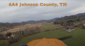
By: Big Orange Bird


Comments
good stuff!
Flew into 6A4 today (6/28/2017). Dave, the airport manager was super nice and extremely accomodating (crew car available). I got a tour of the hangar which included lots of planes he was working on. Then I played a local golf course and when I came back had a nice conversation with him and his lovely wife. Terrain avoidance getting in and out was fun and kept me busy but it's really not a big deal. Just, you know, don't hit stuff and you'll be fine. I highly recommend you check out 6A4 if you're going to this area for any reason. Thanks again Dave!
Great place!
I visit quite frequently to 6A4 and it will soon be my base airport. The FBO, Dave Garris is the nicest FBO I have ever had the pleasure of meeting. He is very knowledgeable in all aspects of aviation and continues to promote aviation of all kinds. That's what a real aviator is all about! Thanks Dave!