Login
Register
MRN
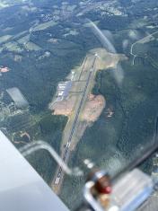
Foothills Regional Airport
Official FAA Data Effective 2026-01-22 0901Z
VFR Chart of KMRN
Sectional Charts at SkyVector.com
IFR Chart of KMRN
Enroute Charts at SkyVector.com
Location Information for KMRN
Coordinates: N35°49.21' / W81°36.69'Located 06 miles NE of Morganton, North Carolina on 1170 acres of land. View all Airports in North Carolina.
Surveyed Elevation is 1269 feet MSL.
Operations Data
|
|
Airport Communications
| AWOS-3P: | 124.175 Tel. 828-757-0788 |
|---|---|
| UNICOM: | 122.700 |
| CTAF: | 122.700 |
| ASOS at HKY (12.1 SE): | 118.325 828-322-2996 |
| AWOS-3PT at TNB (22.8 N): | 119.250 828-268-8921 |
| AWOS-3 at FQD (28.3 SW): | 118.275 828-287-6498 |
- APCH/DEP SVC PRVDD BY ATLANTA ARTCC (ZTL) ON FREQS 125.15/263.0 (HICKORY RCAG).
Nearby Navigation Aids
|
| ||||||||||||||||||||||||||||||||||||||||||||||||||||||||||||
Runway 03/21
| Dimensions: | 5500 x 75 feet / 1676 x 23 meters | |
|---|---|---|
| Surface: | Asphalt in Good Condition | |
| Weight Limits: | D-60 | |
| Edge Lighting: | Medium Intensity | |
| Runway 03 | Runway 21 | |
| Coordinates: | N35°48.80' / W81°36.91' | N35°49.63' / W81°36.46' |
| Elevation: | 1230.2 | 1269.7 |
| Traffic Pattern: | Left | Left |
| Runway Heading: | 24° True | 204° True |
| Markings: | Non-Precision Instrument in good condition. | Non-Precision Instrument in good condition. |
| Glide Slope Indicator | P4L (3.00° Glide Path Angle) | P4R (3.50° Glide Path Angle) |
| REIL: | Yes | Yes |
| Obstacles: | 10 ft Trees 612 ft from runway, 306 ft left of center | 16 ft Trees 548 ft from runway, 237 ft left of center |
Services Available
| Fuel: | 100LL (blue), Jet A-1+ |
|---|---|
| Transient Storage: | Tiedowns |
| Airframe Repair: | MAJOR |
| Engine Repair: | MAJOR |
| Bottled Oxygen: | LOW |
| Bulk Oxygen: | HIGH |
| Other Services: | AIR FREIGHT SERVICES,CARGO HANDLING SERVICES,GLIDER SERVICE,PILOT INSTRUCTION,AIRCRAFT RENTAL,AIRCRAFT SALES,GLIDER TOWING SERVICES |
Ownership Information
| Ownership: | Publicly owned | |
|---|---|---|
| Owner: | FOOTHILLS REGIONAL AIRPORT AUTHORIT | |
| 3566 FOOTHILLS AIRPORT RD | ||
| MORGANTON, NC 28655 | ||
| 828-757-0099 | ||
| Manager: | BRENT BRINKLEY | |
| 3566 FOOTHILLS AIRPORT RD | ||
| MORGANTON, NC 28655 | ||
| 828-757-0099 | ||
Other Remarks
- APRON TIE DOWN SPACE LTD.
- RY 03, 100 FT DROPOFF 330 FT FM THLD AND 80 FT BOTH SIDES OF CNTRLN ALONG FIRST 1000 FT OF RY.
- RY 21, 30 FT DROPOFF 400 FT FM THLD BOTH SIDES AND 10 FT DROPOFF 50 FT FM THLD AND 150 FT RIGHT OF CNTRLN.
- HANG GLIDER ACT DALGT HRS - EAST SIDE OF RWY 03/21 IN RWY SAFETY AREA.
- DEER & COYOTE ON & INVOF ARPT.
- FOR CD CTC ATLANTA ARTCC AT 770-210-7692.
- 0LL AFTER HOURS FUEL OR SERVICE CALL 828-757-0099
- ACTVT REILS RWY 03 & 21; PAPI RWY 03 & 21; MIRL RWY 03/21 - CTAF.
Weather Minimums
Instrument Approach Procedure (IAP) Charts
Nearby Airports with Instrument Procedures
| ID | Name | Heading / Distance | ||
|---|---|---|---|---|
 |
KHKY | Hickory Regional Airport | 113° | 11.8 |
 |
KFQD | Rutherford County/Marchman Field Airport | 214° | 28.3 |
 |
KIPJ | Lincoln County Regional Airport | 132° | 29.9 |
 |
KSVH | Statesville Regional Airport | 095° | 32.3 |
 |
KEHO | Shelby-Cleveland County Regional Airport | 179° | 33.8 |
 |
KUKF | Wilkes County Airport | 045° | 34.7 |
 |
14A | Lake Norman Airpark Airport | 109° | 36.9 |
 |
6A4 | Johnson County Airport | 343° | 37.3 |
 |
KGEV | Ashe County Airport | 014° | 37.9 |
 |
0A9 | William B Greene Jr Regional Airport | 320° | 42.8 |
 |
KAKH | Gastonia Municipal Airport | 148° | 43.4 |
 |
KZEF | Elkin Municipal Airport | 055° | 48.7 |


