Login
Register


JFZ
Tazewell County Airport
Official FAA Data Effective 2026-02-19 0901Z
Chart Supplement

VFR Chart of KJFZ
Sectional Charts at SkyVector.com
IFR Chart of KJFZ
Enroute Charts at SkyVector.com
Location Information for KJFZ
Coordinates: N37°3.82' / W81°47.90'Located 02 miles S of Richlands, Virginia on 204 acres of land. View all Airports in Virginia.
Surveyed Elevation is 2653 feet MSL.
Operations Data
|
|
Airport Communications
| AWOS-3: | 118.075 Tel. 276-596-9927 |
|---|---|
| UNICOM: | 123.050 |
| CTAF: | 123.050 |
| AWOS-3 at MKJ (23.8 SE): | 123.875 276-686-6420 |
| AWOS-3 at VJI (25.4 SW): | 128.125 276-628-2940 |
| ASOS at BLF (31.7 NE): | 132.725 304-327-5766 |
- APCH/DEP SVC PRVDD BY ATLANTA ARTCC (ZTL) ON FREQS 127.85/269.3 (GLADE SPRINGS RCAG).
Nearby Navigation Aids
|
| ||||||||||||||||||||||||||||||||||||||||||||||||||||||||||||


Runway 07/25
| Dimensions: | 4299 x 75 feet / 1310 x 23 meters | |
|---|---|---|
| Surface: | Asphalt in Good Condition | |
| Weight Limits: | S-12, D-18 | |
| Edge Lighting: | Medium Intensity | |
| Runway 07 | Runway 25 | |
| Coordinates: | N37°3.68' / W81°48.30' | N37°3.97' / W81°47.49' |
| Elevation: | 2652.8 | 2653.1 |
| Runway Heading: | 66° True | 246° True |
| Markings: | Non-Precision Instrument in good condition. | Non-Precision Instrument in good condition. |
| Glide Slope Indicator | P2L (3.50° Glide Path Angle) | P2L (3.50° Glide Path Angle) |
| REIL: | Yes | Yes |
| Obstacles: | 8 ft Trees 204 ft from runway, 132 ft left of center CTLNG OBSTN EXCEEDS A 45 DEG SLP. BRUSH 113 FT L OF CNTRLN AND OVER EMBANKMENT ADJ TO RWY. |
17 ft Tree 227 ft from runway, 131 ft left of center |
Services Available
| Fuel: | 100LL (blue), Jet A+ |
|---|---|
| Transient Storage: | Tiedowns |
| Airframe Repair: | NOT AVAILABLE |
| Engine Repair: | NOT AVAILABLE |
| Bottled Oxygen: | NOT AVAILABLE |
| Bulk Oxygen: | NOT AVAILABLE |
| Other Services: | AIRCRAFT RENTAL |
Ownership Information
| Ownership: | Publicly owned | |
|---|---|---|
| Owner: | TAZEWELL CO AIRPORT AUTHORITY | |
| 2200 AIRPORT ROAD | ||
| CEDAR BLUFF, VA 24609 | ||
| 276-963-4509 | ||
| Manager: | JAMES FRENCH | |
| 2200 AIRPORT ROAD | ||
| CEDAR BLUFF, VA 24609 | ||
| 276-963-4509 | ||
Other Remarks
- GCO AVBL ON FREQ 135.075 THRU ZTL CLEARANCE DELIVERY AND DCA RADIO - INOP.
- FOR CD IF UNA VIA GCO CTC ATLANTA ARTCC AT 770-210-7692.
- FOR SUN SVC, CALL APRT DURG RGLR BUS HRS TO ARNG. AFT HRS NRS LISTED ON DOOR.
- MIRL RWY 07/25 PRESET LOW INTST. TO INCREASE INTST & ACTVT REIL RWYS 07 & 25; PAPI RWY 07 & 25 - CTAF.
Weather Minimums

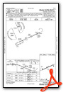
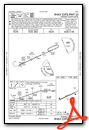
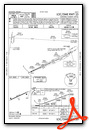
Instrument Approach Procedure (IAP) Charts
Nearby Airports with Instrument Procedures
| ID | Name | Heading / Distance | ||
|---|---|---|---|---|
 |
KMKJ | Mountain Empire Airport | 115° | 23.8 |
|
KVJI | Virginia Highlands Airport | 206° | 25.3 |
|
KBLF | Mercer County Airport | 063° | 31.6 |
|
I16 | Kee Field Airport | 019° | 34.1 |
|
KLNP | Lonesome Pine Airport | 262° | 35.4 |
|
6A4 | Johnson County Airport | 181° | 38.7 |
|
KEBD | Southern West Virginia Regional Airport | 337° | 40.1 |
|
KGEV | Ashe County Airport | 154° | 42.0 |
|
0A9 | William B Greene Jr Regional Airport | 203° | 45.2 |
|
KTRI | Tri-Cities Airport | 219° | 45.9 |
|
KPBX | Pike County/Hatcher Field Airport | 309° | 47.4 |
|
6L4 | Logan County Airport | 353° | 47.8 |
Airport Images

By: Big Orange Bird

By: Big Orange Bird


