Login
Register


AFW
Perot Field/Fort Worth Alliance Airport
Official FAA Data Effective 2026-02-19 0901Z
From the Flight Deck
Chart Supplement

KAFW Airport Diagram

VFR Chart of KAFW
Sectional Charts at SkyVector.com
IFR Chart of KAFW
Enroute Charts at SkyVector.com
Location Information for KAFW
Coordinates: N32°59.42' / W97°19.17'Located 14 miles N of Fort Worth, Texas on 1198 acres of land. View all Airports in Texas.
Surveyed Elevation is 723 feet MSL.
Operations Data
|
|
Airport Communications
| ATIS: | 126.925 |
|---|---|
| ASOS: | Tel. 817-491-6188 |
| ALLIANCE TOWER: | 120.825 ;HELICOPTERS 135.15 257.9 |
| ALLIANCE GROUND: | 132.65 306.2 |
| LONE STAR APPROACH: | 118.1 306.95 |
| LONE STAR DEPARTURE: | 118.1 306.95 |
| CLEARANCE DELIVERY: | 128.725 |
| REEKO STAR: | 125.2 343.65 |
| GARLAND DP: | 118.1 306.95 |
| MOTZA STAR: | 118.1 ;SOUTH 125.8 ;NORTH 306.95 |
| TRUUK RNAV STAR: | 124.3 282.275 |
| BOTCH DP: | 118.1 306.95 |
| DODJE STAR: | 125.2 125.9 343.65 |
| JOE POOL DP: | 118.1 306.95 |
| WESAT STAR: | 118.1 ;SOUTH 125.8 ;NORTH 306.95 |
| NANDR RNAV DP: | 118.1 306.95 |
| SASIE STAR: | 124.3 282.275 |
| LIKES STAR: | 125.8 ;SOUTH 135.975 ;NORTH 257.95 |
| DALLAS AREA DP: | 118.1 306.95 |
| ASOS at FTW (10.2 S): | 817-740-3346 |
| ATIS at FTW (10.5 S): | 120.7 |
| ATIS at DTO (14.1 NE): | 119.325 |
- EMERGENCY FREQ NOT AVBL.
- SAID IN USE. OPERATE TRANSPONDERS WITH ALTITUDE REPORTING MODE AND ADS-B (IF EQUIPPED) ENABLED ON ALL AIRPORT SURFACES.
Nearby Navigation Aids
|
| ||||||||||||||||||||||||||||||||||||||||||||||||||||||||||||


Runway 16R/34L
| Dimensions: | 11125 x 150 feet / 3391 x 46 meters | |
|---|---|---|
| Surface: | Concrete / Grooved in Good Condition | |
| Weight Limits: | D-200, ST-400, DT-870
PCR VALUE: 768/R/B/W/T
| |
| Edge Lighting: | High Intensity | |
| Runway 16R | Runway 34L | |
| Coordinates: | N33°0.31' / W97°19.41' | N32°58.50' / W97°19.04' |
| Elevation: | 721.2 | 664.7 |
| Traffic Pattern: | Right | Left |
| Runway Heading: | 170° True | 350° True |
| Displaced Threshold: | 716 Feet | |
| Declared Distances: | TORA:11010 TODA:11010 ASDA:10410 LDA:10410 | TORA:11010 TODA:11010 ASDA:11010 LDA:10409 |
| Markings: | Precision Instrument in good condition. | Precision Instrument in good condition. |
| Glide Slope Indicator | P4R (3.00° Glide Path Angle) | P4L (3.00° Glide Path Angle) |
| REIL: | Yes | Yes |
| Obstacles: | 19 ft Railroad 607 ft from runway, 287 ft right of center APCH RATIO 0:1 BASED ON DSPLCD THLD; +5 FT FENCE 0 FT, 250 FT R. |
4 ft Fence 200 ft from runway, 250 ft left of center APCH RATIO 50:1 TO DSPLCD THLD. +4 FT FENCE 0 FT 250 FT L; APCH RATIO 0:1 BASED ON DSPLCD THLD. |
Runway 16L/34R
| Dimensions: | 11000 x 150 feet / 3353 x 46 meters | |
|---|---|---|
| Surface: | Concrete / Grooved in Good Condition | |
| Weight Limits: | D-200, ST-400, DT-870
PCR VALUE: 768/R/B/W/T
| |
| Edge Lighting: | High Intensity | |
| Runway 16L | Runway 34R | |
| Coordinates: | N33°0.33' / W97°19.29' | N32°58.54' / W97°18.93' |
| Elevation: | 723.1 | 664.2 |
| Traffic Pattern: | Right | Left |
| Runway Heading: | 170° True | 350° True |
| Declared Distances: | TORA:11000 TODA:11000 ASDA:10600 LDA:10600 | TORA:11000 TODA:11000 ASDA:11000 LDA:11000 |
| Markings: | Precision Instrument in good condition. | Precision Instrument in good condition. |
| RVR Equipment | Touchdown Midfield Rollout | Touchdown Midfield Rollout |
| Approach Lights: | ALSF2 Standard 2,400 Foot High-intensity Approach Lighting System with sequenced flashers, CATEGORY II or III Configuration. | MALSR 1,400 Foot Medium-intensity Approach Lighting System with runway alignment indicator lights. |
| Centerline Lights: | Yes | Yes |
| Obstacles: | 182 ft Power Line 7920 ft from runway, 590 ft right of center | |
Services Available
| Fuel: | 100LL (blue), Jet A-1+ |
|---|---|
| Transient Storage: | Hangars,Tiedowns |
| Airframe Repair: | MAJOR PRIOR ARRANGEMENTS REQUIRED FOR AIRFRAME OR POWER PLANT REPAIRS FOR DESIGN GROUP III & ABOVE. |
| Engine Repair: | MAJOR |
| Bottled Oxygen: | LOW |
| Bulk Oxygen: | NOT AVAILABLE |
| Other Services: | AVIONICS,CARGO HANDLING SERVICES |
Ownership Information
| Ownership: | Publicly owned | |
|---|---|---|
| Owner: | CITY OF FORT WORTH | |
| 1000 THROCKMORTON | ||
| FORT WORTH, TX 76177 | ||
| 817-392-6116 | ||
| Manager: | CHRISTOPHER ASH | |
| 13901 AVIATOR WAY | ||
| FORT WORTH, TX 76177 | ||
| 817-890-1000 | ||
Other Remarks
- FLIGHT NOTIFICATION SERVICE (ADCUS) AVBL.
- PORTIONS OF TWY H MOVEMENT AREA EAST OF TWY A IS NOT VISIBLE FROM ATCT.
- ARINC FREQ 129.75 AVBL.
Weather Minimums


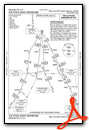
Standard Terminal Arrival (STAR) Charts


Instrument Approach Procedure (IAP) Charts


Departure Procedure (DP) Charts
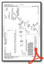
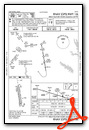
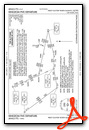
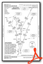
- BOTCH ONE (RNAV)
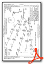
- BOTCH ONE (RNAV), CONT.1
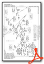
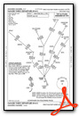
- DALLAS FOUR

- DALLAS FOUR, CONT.1

- GARLAND SIX

- GARLAND SIX, CONT.1
- JOE POOL EIGHT
- JOE POOL EIGHT, CONT.1
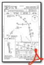
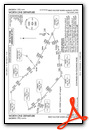
- KINGDOM FIVE
- KINGDOM FIVE, CONT.1

- KUSSO TWO (RNAV)

- KUSSO TWO (RNAV), CONT.1

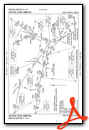
- NANDR THREE (RNAV)
- NANDR THREE (RNAV), CONT.1
- TEXOMA FIVE
- TEXOMA FIVE, CONT.1
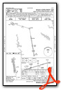
- WORTH ONE
- WORTH ONE, CONT.1
Nearby Airports with Instrument Procedures
| ID | Name | Heading / Distance | ||
|---|---|---|---|---|
 |
4T2 | Kenneth Copeland Airport | 265° | 8.8 |
|
KFTW | Fort Worth Meacham International Airport | 192° | 10.4 |
|
KDTO | Denton Enterprise Airport | 025° | 14.1 |
|
KNFW | Fort Worth NAS Jrb (Carswell Field) Airport | 205° | 14.6 |
|
KDFW | Dallas-Fort Worth International Airport | 111° | 15.3 |
|
KLUD | Decatur Municipal Airport | 320° | 20.6 |
|
KGPM | Grand Prairie Municipal Airport | 141° | 22.2 |
|
KGKY | Arlington Municipal Airport | 149° | 22.6 |
|
KWEA | Parker County Airport | 231° | 23.5 |
|
KADS | Addison Airport | 092° | 24.4 |
|
KDAL | Dallas Love Field Airport | 109° | 25.2 |
|
KFWS | Fort Worth Spinks Airport | 178° | 25.5 |
Airport Images

By: debra.hale@hill...

By: jahangiriali


