Login
Register


MWL
Mineral Wells Regional Airport
Official FAA Data Effective 2026-02-19 0901Z
Chart Supplement

VFR Chart of KMWL
Sectional Charts at SkyVector.com
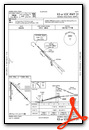
IFR Chart of KMWL
Enroute Charts at SkyVector.com
Location Information for KMWL
Coordinates: N32°46.90' / W98°3.61'Located 03 miles SE of Mineral Wells, Texas on 505 acres of land. View all Airports in Texas.
Estimated Elevation is 973 feet MSL.
Operations Data
|
|
Airport Communications
| ASOS: | 135.075 Tel. 940-325-2457 |
|---|---|
| UNICOM: | 122.725 |
| CTAF: | 122.725 |
| AWOS-3T at GDJ (23.6 SE): | 118.925 817-573-7514 |
| AWOS-3PT at XBP (26.3 NE): | 119.225 940-683-8027 |
| ATIS at NFW (31.2 E): | 351.675 |
- APCH/DEP CTL SVC PRVDD BY FORT WORTH ARTCC (ZFW) ON FREQS 127.0/360.6 (MINERAL WELLS RCAG).
Nearby Navigation Aids
|
| ||||||||||||||||||||||||||||||||||||||||||||||||||||||||||||


Runway 13/31
| Dimensions: | 5996 x 100 feet / 1828 x 30 meters | |
|---|---|---|
| Surface: | Asphalt in Good Condition | |
| Weight Limits: | S-50, D-145 | |
| Edge Lighting: | Medium Intensity | |
| Runway 13 | Runway 31 | |
| Coordinates: | N32°47.25' / W98°3.86' | N32°46.54' / W98°3.04' |
| Elevation: | 913.0 | 969.3 |
| Traffic Pattern: | Left | Left |
| Runway Heading: | 136° True | 316° True |
| Displaced Threshold: | 300 Feet | 400 Feet |
| Markings: | Non-Precision Instrument in fair condition. | Precision Instrument in fair condition. |
| Glide Slope Indicator | P4L (3.00° Glide Path Angle) | P4L (3.00° Glide Path Angle) |
| Obstacles: | 9 ft Fence 201 ft from runway, 345 ft right of center 9 FT FENCE POLE, 8 FT FENCE. APCH SLOPE 10:1 AT DSPLCD THR OVR 35 FT TREES, 560 FT FM DSPLCD THR 248 FT R. 8 FT FENCE, 199 FT DSTC, 347 FT R, 15 FT RD, 199 FT DSTC, 390 FT R. |
15 ft Trees 201 ft from runway, 130 ft right of center APCH SLOPE 0:1 TO DSPLCD THR OVR 10 FT GND 0 FT DSTC, 180 FT LEFT. 10 FT GND 0-199 DSTC, 15 FT TREES, 175 FT DSTC, 150 FT R. |
Runway 17/35
| Dimensions: | 4188 x 100 feet / 1277 x 30 meters | |
|---|---|---|
| Surface: | Asphalt in Good Condition | |
| Weight Limits: | S-50, D-145 | |
| Edge Lighting: | Medium Intensity | |
| Runway 17 | Runway 35 | |
| Coordinates: | N32°47.25' / W98°3.84' | N32°46.56' / W98°3.85' |
| Elevation: | 913.9 | 955.7 |
| Traffic Pattern: | Left | Left |
| Runway Heading: | 181° True | 1° True |
| Displaced Threshold: | 286 Feet | |
| Markings: | Basic in fair condition. | Basic in fair condition. |
| Glide Slope Indicator | P2R (3.00° Glide Path Angle) | P2L (4.00° Glide Path Angle) PAPI UNUSBL BYD 3 DEG L OF CNTRLN. |
| Obstacles: | 35 ft Trees 556 ft from runway, 20 ft left of center | 55 ft Trees 486 ft from runway, 185 ft left of center APCH SLOPE 14:1 TO DSPLCD THR. |
Services Available
| Fuel: | 100LL (blue), Jet-A |
|---|---|
| Transient Storage: | Tiedowns |
| Airframe Repair: | NOT AVAILABLE |
| Engine Repair: | NOT AVAILABLE |
| Bottled Oxygen: | NOT AVAILABLE |
| Bulk Oxygen: | NONE |
| Other Services: | PILOT INSTRUCTION |
Ownership Information
| Ownership: | Publicly owned | |
|---|---|---|
| Owner: | CITY OF MINERAL WELLS | |
| PO BOX 460 | ||
| MINERAL WELLS, TX 76068 | ||
| 940-328-7700 | ||
| Manager: | HALEY CUEVAS | |
| 5300 AIRPORT RD. | ||
| MINERAL WELLS, TX 76067 | ||
| 940-328-7809 | ||
Other Remarks
- THIS AIRPORT HAS BEEN SURVEYED BY THE NATIONAL GEODETIC SURVEY.
- RWY 13/31 RWY ENDS NOT VSB FM OPPOSITE END.
- FOR CD IF UNA TO CTC ON FSS FREQ, CTC FORT WORTH ARTCC AT 817-858-7584.
- RWY 13, DITCH 6 FT DEEP, 8 FT WIDE, 50 FT LONG, BTWN RWY THR & TWY A.
- 0LL FOR FUEL AFT HRS CALL 940-328-7770.
- DUSK-DAWN. MIRL RWYS 13/31 & 17/35 PRESET LOW INTST; TO INCR INTST ACTVT - CTAF.
Weather Minimums


Instrument Approach Procedure (IAP) Charts


Nearby Airports with Instrument Procedures
| ID | Name | Heading / Distance | ||
|---|---|---|---|---|
 |
KWEA | Parker County Airport | 096° | 19.2 |
|
F35 | Possum Kingdom Airport | 294° | 20.8 |
|
KGDJ | Granbury Regional Airport | 149° | 23.6 |
|
KXBP | Bridgeport Municipal Airport | 026° | 26.2 |
|
50F | Bourland Field Airport | 116° | 26.6 |
|
4T2 | Kenneth Copeland Airport | 067° | 31.0 |
|
KNFW | Fort Worth NAS Jrb (Carswell Field) Airport | 091° | 31.3 |
|
KRPH | Graham Municipal Airport | 308° | 31.8 |
|
KSEP | Stephenville Clark Regional Airport | 190° | 34.4 |
|
KFTW | Fort Worth Meacham International Airport | 086° | 35.4 |
|
KLUD | Decatur Municipal Airport | 040° | 37.2 |
|
KAFW | Perot Field/Fort Worth Alliance Airport | 071° | 39.5 |
Airport Images
Do you have a recent image of this airport? Upload it here!


