Login
Register


M02
Dickson Municipal Airport
Official FAA Data Effective 2026-02-19 0901Z
Chart Supplement

VFR Chart of M02
Sectional Charts at SkyVector.com
IFR Chart of M02
Enroute Charts at SkyVector.com
Location Information for M02
Coordinates: N36°7.68' / W87°25.79'Located 03 miles N of Dickson, Tennessee on 362 acres of land. View all Airports in Tennessee.
Surveyed Elevation is 892 feet MSL.
Operations Data
|
|
Airport Communications
| AWOS-3: | 123.875 Tel. 615-446-5481 |
|---|---|
| NASHVILLE APPROACH: | 119.35 372.0 |
| NASHVILLE DEPARTURE: | 119.35 372.0 |
| CTAF: | 122.800 |
| UNICOM: | 122.800 |
| ATIS at EOD (26.5 N): | 306.5 |
| AWOS-3 at EOD (26.5 N): | 270-956-3100 |
| ATIS at JWN (26.5 E): | 127.075 |
Nearby Navigation Aids
|
| ||||||||||||||||||||||||||||||||||||||||||||||||||||||||||||


Runway 17/35
| Dimensions: | 5001 x 75 feet / 1524 x 23 meters | |
|---|---|---|
| Surface: | Asphalt in Good Condition | |
| Weight Limits: | 17 /F/C/X/T, S-46, D-65 | |
| Edge Lighting: | Medium Intensity | |
| Runway 17 | Runway 35 | |
| Coordinates: | N36°8.09' / W87°25.86' | N36°7.27' / W87°25.72' |
| Elevation: | 892.1 | 868.0 |
| Traffic Pattern: | Left | Left |
| Runway Heading: | 172° True | 352° True |
| Markings: | Non-Precision Instrument in good condition. | Non-Precision Instrument in good condition. |
| REIL: | Yes | Yes |
| Obstacles: | 13 ft Tree 335 ft from runway, 51 ft left of center | 52 ft Tree 836 ft from runway, 128 ft right of center |
Services Available
| Fuel: | 100LL (blue), Jet A+ |
|---|---|
| Transient Storage: | Tiedowns |
| Airframe Repair: | MINOR |
| Engine Repair: | MAJOR |
| Bottled Oxygen: | NONE |
| Bulk Oxygen: | NONE |
| Other Services: | PILOT INSTRUCTION,AIRCRAFT RENTAL |
Ownership Information
| Ownership: | Publicly owned | |
|---|---|---|
| Owner: | DICKSON COUNTY ARPT AUTHORITY | |
| P.O.BOX 901 | ||
| DICKSON, TN 37056 | ||
| 615-446-6611 | ||
| Manager: | MIKE GALLAGHER | |
| 2372 SYLVIA RD | ||
| DICKSON, TN 37056 | ||
| (615) 812-1981 | ||
Other Remarks
- FOR CD CTC NASHVILLE APCH AT 615-695-4524.
Weather Minimums

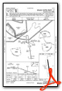
Instrument Approach Procedure (IAP) Charts
Nearby Airports with Instrument Procedures
| ID | Name | Heading / Distance | ||
|---|---|---|---|---|
 |
0M5 | Humphreys County Airport | 267° | 15.0 |
|
KGHM | Centerville Municipal Airport | 182° | 17.4 |
|
KJWN | John C Tune Airport | 082° | 26.6 |
|
KCKV | Outlaw Field Airport | 001° | 29.6 |
|
KHOP | Campbell AAF (Fort Campbell) Airport | 354° | 32.8 |
|
0M4 | Benton County Airport | 258° | 34.5 |
|
M91 | Springfield Robertson County Airport | 045° | 34.8 |
|
0M3 | Paul Bridges Field Airport | 193° | 35.8 |
|
KBNA | Nashville International Airport | 090° | 36.5 |
|
KMRC | Maury County Regional Airport | 160° | 36.5 |
|
KHVC | Hopkinsville-Christian County Airport | 358° | 43.7 |
|
KMQY | Smyrna Airport | 098° | 44.8 |
Airport Images

By: Big Orange Bird

By: lynnkramer1211@...


