Login
Register


JWN
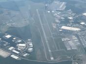
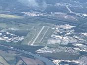
John C Tune Airport
Official FAA Data Effective 2026-01-22 0901Z
Chart Supplement

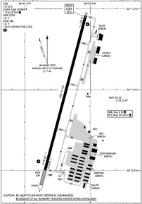
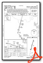
KJWN Airport Diagram
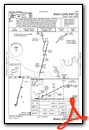
VFR Chart of KJWN
Sectional Charts at SkyVector.com
IFR Chart of KJWN
Enroute Charts at SkyVector.com
Location Information for KJWN
Coordinates: N36°10.98' / W86°53.19'Located 01 miles NW of Nashville, Tennessee on 374 acres of land. View all Airports in Tennessee.
Surveyed Elevation is 501 feet MSL.
Operations Data
|
|
Airport Communications
| ATIS: | 127.075 (615-350-6222) |
|---|---|
| AWOS-3: | Tel. 615-350-6222 |
| JOHN TUNE TOWER: | 119.45 |
| JOHN TUNE GROUND: | 121.7 |
| NASHVILLE APPROACH: | 119.35 372.0 |
| NASHVILLE DEPARTURE: | 119.35 372.0 |
| CLEARANCE DELIVERY: | 121.7 124.55 ;WHEN TWR CLSD |
| CTAF: | 119.450 |
| UNICOM: | 122.700 |
| ASOS at BNA (10.6 SE): | 629-236-5115 |
| D-ATIS at BNA (10.7 E): | 135.1 |
| AWOS-3PT at MQY (21.0 SE): | 119.125 615-223-7716 |
Nearby Navigation Aids
|
| ||||||||||||||||||||||||||||||||||||||||||||||||||||||||||||


Runway 02/20
| Dimensions: | 6001 x 100 feet / 1829 x 30 meters | |
|---|---|---|
| Surface: | Asphalt / Grooved in Good Condition | |
| Weight Limits: | S-35, D-97 | |
| Edge Lighting: | Medium Intensity | |
| Runway 02 | Runway 20 | |
| Coordinates: | N36°10.50' / W86°53.35' | N36°11.46' / W86°53.03' |
| Elevation: | 458.6 | 501.0 |
| Traffic Pattern: | Right | |
| Runway Heading: | 15° True | 195° True |
| Declared Distances: | TORA:6001 TODA:6001 ASDA:6001 LDA:6001 | TORA:6001 TODA:6001 ASDA:6001 LDA:6001 |
| Markings: | Non-Precision Instrument in good condition. | Precision Instrument in good condition. |
| Glide Slope Indicator | P4L (3.00° Glide Path Angle) | P4L (3.00° Glide Path Angle) |
| REIL: | Yes | Yes |
| Obstacles: | 49 ft Tree 1545 ft from runway, 348 ft right of center | 63 ft Tree 2166 ft from runway, 440 ft right of center |
Services Available
| Fuel: | 100LL (blue), Jet A+ |
|---|---|
| Transient Storage: | Hangars,Tiedowns |
| Airframe Repair: | MAJOR |
| Engine Repair: | MAJOR |
| Bottled Oxygen: | HIGH |
| Bulk Oxygen: | LOW |
| Other Services: | AVIONICS,CHARTER SERVICE,PILOT INSTRUCTION,AIRCRAFT RENTAL,AIRCRAFT SALES HEL & FIXED WING. |
Ownership Information
| Ownership: | Publicly owned | |
|---|---|---|
| Owner: | METRO NASHVILLE APT AUTHORITY | |
| ONE TERMINAL DR. | ||
| NASHVILLE, TN 37214 | ||
| 615-275-1600 | ||
| Manager: | ADAM C. WOLF | |
| 1000 TUNE AIRPORT DRIVE | ||
| NASHVILLE, TN 37209 | ||
| 615-275-1783 | ||
Other Remarks
- BIRDS & DEER INVOF ARPT.
- BLEEDOVER OCR ALL FREQS 1.75 NM NORTH OF RWY.
- WHEN ATCT CLSD FOR CD CTC NASHVILLE APCH ON 124.55, IF UNABLE CALL 615-695-4524.
- TWY R1 CLSD TO ACFT WINGSPAN MORE THAN 49FT
- TWY R2 CLSD TO ACFT WINGSPAN MORE THAN 79FT
- WHEN ATCT CLSD ACTVT REIL RWY 02 & 20; PAPI RWY 02 & 20; MIRL RWY 02/20 - CTAF.
- ENGINEERED MATERIAL ARRESTING SYSTEM (EMAS) 186 FT LONG BY 121 FT WIDE LCTD 560 FT FM DEP END RWY 20.
Weather Minimums

Instrument Approach Procedure (IAP) Charts
Departure Procedure (DP) Charts
Nearby Airports with Instrument Procedures
| ID | Name | Heading / Distance | ||
|---|---|---|---|---|
 |
KBNA | Nashville International Airport | 109° | 10.7 |
|
KMQY | Smyrna Airport | 120° | 20.6 |
|
M91 | Springfield Robertson County Airport | 355° | 21.3 |
|
KXNX | Music City Exec Airport | 063° | 25.9 |
|
M02 | Dickson Municipal Airport | 263° | 26.6 |
|
M54 | Lebanon Municipal Airport | 088° | 27.7 |
|
KMBT | Murfreesboro Municipal Airport | 126° | 30.8 |
|
1M5 | Douglas Hunter Field Airport | 038° | 31.6 |
|
KGHM | Centerville Municipal Airport | 232° | 34.2 |
|
KCKV | Outlaw Field Airport | 315° | 36.7 |
|
4M7 | Russellville-Logan County Airport | 005° | 37.1 |
|
KMRC | Maury County Regional Airport | 200° | 40.3 |