Login
Register


13WA
Rocky Pond Airstrip Airport
Official FAA Data Effective 2025-11-27 0901Z
VFR Chart of 13WA
Sectional Charts at SkyVector.com
IFR Chart of 13WA
Enroute Charts at SkyVector.com
Location Information for 13WA
Coordinates: N47°46.23' / W120°8.01'Located 10 miles NE of Orondo, Washington. View all Airports in Washington.
Estimated Elevation is 826 feet MSL.
Operations Data
|
|
Airport Communications
| ASOS at EAT (22.6 S): | 119.925 509-886-4226 |
|---|---|
| ASOS at EPH (37.4 SE): | 135.775 509-754-3761 |
| AWOS-3 at S52 (39.5 N): | 118.425 509-997-0142 |
Nearby Navigation Aids
|
| ||||||||||||||||||||||||||||||||||||||||||


Runway 09/27
| Dimensions: | 2722 x 60 feet / 830 x 18 meters | |
|---|---|---|
| Surface: | Asphalt in Fair Condition | |
| Runway 09 | Runway 27 | |
Ownership Information
| Ownership: | Privately Owned | |
|---|---|---|
| Owner: | DAVID DUFENHORST | |
| P.O. BOX 98 | ||
| WOODINVILLE, WA 98072 | ||
| 206-458-9119 | ||
| Manager: | DAVID DUFENHORST | |
| P.O. BOX 98 | ||
| WOODINVILLE, WA 98072 | ||
| 206-458-9119 | ||
Other Remarks
- FOR CD CTC SEATTLE ARTCC AT 253-351-3694.
Nearby Airports with Instrument Procedures
| ID | Name | Heading / Distance | ||
|---|---|---|---|---|
 |
KEAT | Pangborn Memorial Airport | 187° | 22.5 |
|
KEPH | Ephrata Municipal Airport | 137° | 37.4 |
|
3W7 | Grand Coulee Dam Airport | 077° | 43.4 |
|
KELN | Bowers Field Airport | 200° | 47.0 |
|
KMWH | Grant County International Airport | 135° | 47.3 |
|
KOMK | Omak Airport | 030° | 48.5 |
|
2S8 | Wilbur Airport | 090° | 56.3 |
|
KYKM | Yakima Air Trml/Mcallister Field Airport | 193° | 74.1 |
|
S43 | Harvey Field Airport | 276° | 80.0 |
|
KAWO | Arlington Municipal Airport | 286° | 85.0 |
|
KRNT | Renton Municipal Airport | 259° | 86.1 |
|
KPAE | Seattle Paine Field International Airport | 276° | 87.2 |
Airport Images
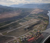
By: dthomas.novo@gm...


