Login
Register


18A
Franklin-Hart Airport
Official FAA Data Effective 2026-01-22 0901Z
Chart Supplement

VFR Chart of 18A
Sectional Charts at SkyVector.com
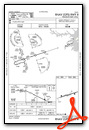
IFR Chart of 18A
Enroute Charts at SkyVector.com
Location Information for 18A
Coordinates: N34°20.42' / W83°7.85'Located 01 miles SW of Canon, Georgia on 143 acres of land. View all Airports in Georgia.
Estimated Elevation is 889 feet MSL.
Operations Data
|
|
Airport Communications
| AWOS-3PT: | 118.625 Tel. 706-245-1097 |
|---|---|
| CTAF: | 122.900 |
| AWOS-3 at TOC (17.0 NW): | 119.625 706-297-7473 |
| AWOS-3 at EBA (21.6 SE): | 118.15 706-283-8133 |
| ASOS at AND (22.8 NE): | 120.675 864-226-9522 |
- APCH/DEP SVC PRVDD BY ATLANTA ARTCC ON FREQS 127.5/316.05 (ATHENS RCAG).
Nearby Navigation Aids
|
| ||||||||||||||||||||||||||||||||||||||||||||||||||||||||||||


Runway 08/26
| Dimensions: | 5000 x 75 feet / 1524 x 23 meters | |
|---|---|---|
| Surface: | Asphalt in Good Condition | |
| Weight Limits: | S-15 | |
| Edge Lighting: | Medium Intensity | |
| Runway 08 | Runway 26 | |
| Coordinates: | N34°20.29' / W83°8.32' | N34°20.55' / W83°7.38' |
| Elevation: | 828.5 | 889.9 |
| Runway Heading: | 72° True | 252° True |
| Markings: | Non-Precision Instrument in fair condition. | Non-Precision Instrument in fair condition. |
| Glide Slope Indicator | P2L (3.00° Glide Path Angle) | P2L (3.00° Glide Path Angle) |
| Obstacles: | 42 ft Trees 578 ft from runway, 294 ft left of center | 84 ft Trees 1796 ft from runway, 351 ft left of center |
Services Available
| Fuel: | 100LL (blue), Jet-A |
|---|---|
| Transient Storage: | Tiedowns |
| Airframe Repair: | NONE |
| Engine Repair: | NONE |
| Bottled Oxygen: | NONE |
| Bulk Oxygen: | NONE |
| Other Services: | PILOT INSTRUCTION |
Ownership Information
| Ownership: | Publicly owned | |
|---|---|---|
| Owner: | FRANKLIN COUNTY | FRANKLIN-HART AIRPORT AUTHORITY. |
| 823 AIRPORT ROAD | ||
| CANON, GA 30520 | ||
| 706-244-0383 | ||
| Manager: | CHUCK FLOYD | AIRPORT AUTHORITY. |
| 823 AIRPORT ROAD | ||
| CANON, GA 30520 | ||
| 321-514-9571 | ARPT PHONE 706-245-1002. | |
Other Remarks
- FOR CD CTC ATLANTA ARTCC AT 770-210-7692.
- 0LL SELF SVC 100LL AND A FUEL AVBL 24 HRS WITH CREDIT CARD.
- DUSK-0000. AFT 0000, ACTVT PAPI RWY 08 & 26; MIRL RWY 08/26 - CTAF.
Weather Minimums

Instrument Approach Procedure (IAP) Charts

Nearby Airports with Instrument Procedures
| ID | Name | Heading / Distance | ||
|---|---|---|---|---|
 |
KTOC | Toccoa Rg Letourneau Field Airport | 331° | 17.2 |
|
KEBA | Elbert County-Patz Field Airport | 133° | 21.4 |
|
KAND | Anderson Regional Airport | 066° | 22.9 |
|
KAJR | Habersham County Airport | 294° | 23.2 |
|
KCEU | Oconee County Regional Airport | 031° | 23.3 |
|
KJCA | Jackson County Airport | 245° | 23.6 |
|
KAHN | Athens/Ben Epps Airport | 202° | 25.4 |
|
KWDR | Barrow County Airport | 231° | 34.2 |
|
KGVL | Lee Gilmer Memorial Airport | 263° | 35.0 |
|
KLQK | Pickens County Airport | 036° | 35.2 |
|
KIIY | Washington/Wilkes County Airport | 154° | 37.2 |
|
D73 | Cy Nunnally Memorial Airport | 220° | 43.6 |
Airport Images
Do you have a recent image of this airport? Upload it here!


