Login
Register


TOC
Toccoa Rg Letourneau Field Airport
Official FAA Data Effective 2026-01-22 0901Z
Chart Supplement

VFR Chart of KTOC
Sectional Charts at SkyVector.com
IFR Chart of KTOC
Enroute Charts at SkyVector.com
Location Information for KTOC
Coordinates: N34°35.57' / W83°17.78'Located 02 miles NE of Toccoa, Georgia on 285 acres of land. View all Airports in Georgia.
Surveyed Elevation is 996 feet MSL.
Operations Data
|
|
Airport Communications
| AWOS-3: | 119.625 Tel. 706-297-7473 |
|---|---|
| UNICOM: | 122.800 |
| CTAF: | 122.800 |
| AWOS-3 at AJR (13.8 SW): | 119.175 706-778-3675 |
| AWOS-3PT at 18A (17.2 SE): | 118.625 706-245-1097 |
| ASOS at CEU (21.0 E): | 119.275 864-653-8855 |
- APCH/DEP SVC PRVDD BY ATLANTA ARTCC ON FREQS 134.8/379.95 (MOUNT OGLETHORPE RCAG).
Nearby Navigation Aids
|
| ||||||||||||||||||||||||||||||||||||||||||||||||||||||||||||


Runway 03/21
| Dimensions: | 5008 x 100 feet / 1526 x 30 meters | |
|---|---|---|
| Surface: | Asphalt in Good Condition | |
| Weight Limits: | S-30 | |
| Edge Lighting: | Medium Intensity | |
| Runway 03 | Runway 21 | |
| Coordinates: | N34°35.09' / W83°18.06' | N34°35.86' / W83°17.70' |
| Elevation: | 995.7 | 968.3 |
| Traffic Pattern: | Left | Left |
| Runway Heading: | 21° True | 201° True |
| Markings: | Non-Precision Instrument in fair condition. | Non-Precision Instrument in fair condition. |
| Glide Slope Indicator | P2L (3.25° Glide Path Angle) | P2L (3.00° Glide Path Angle) |
| REIL: | Yes | Yes |
| Obstacles: | 51 ft Trees 1271 ft from runway, 343 ft left of center | 18 ft Trees 218 ft from runway, 247 ft right of center |
Runway 09/27
| Dimensions: | 2951 x 50 feet / 899 x 15 meters | |
|---|---|---|
| Surface: | Asphalt in Good Condition | |
| Weight Limits: | S-20 | |
| Runway 09 | Runway 27 | |
| Coordinates: | N34°35.71' / W83°17.91' | N34°35.73' / W83°17.32' |
| Elevation: | 972.0 | 948.0 |
| Traffic Pattern: | Left | Left |
| Runway Heading: | 88° True | 268° True |
| Markings: | Basic in good condition. | Basic in good condition. |
| Obstacles: | 18 ft Trees 296 ft from runway, 134 ft left of center CONTROLLING OBSTRUCTION EXCEEDS A 45 DEGREE SLOPE |
38 ft Trees 211 ft from runway, 110 ft right of center |
Services Available
| Fuel: | 100LL (blue), Jet A+ |
|---|---|
| Transient Storage: | Tiedowns |
| Airframe Repair: | MAJOR |
| Engine Repair: | MAJOR |
| Bottled Oxygen: | NONE |
| Bulk Oxygen: | NONE |
| Other Services: | PILOT INSTRUCTION,AIRCRAFT RENTAL |
Ownership Information
| Ownership: | Publicly owned | |
|---|---|---|
| Owner: | TOCCOA-STEPHENS CO AUTH | |
| PO BOX 494 | ||
| TOCCOA, GA 30577 | ||
| 706-886-5632 | ||
| Manager: | AMBER MCCALL | |
| PO BOX 494 | ||
| TOCCOA, GA 30577 | ||
| 706-886-5632 | ||
Other Remarks
- DEER ON OR INVOF ARPT
- FOR CD CTC ATLANTA ARTCC AT 770-210-7692.
- DUSK-2200. AFTER 2200 ACTVT MIRL RY 03/21, REIL RYS 03 & 21, PAPI RYS 03 & 21 - CTAF.
Weather Minimums

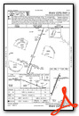
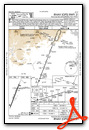
Instrument Approach Procedure (IAP) Charts
Nearby Airports with Instrument Procedures
| ID | Name | Heading / Distance | ||
|---|---|---|---|---|
 |
KAJR | Habersham County Airport | 246° | 14.1 |
|
18A | Franklin-Hart Airport | 151° | 17.2 |
|
KCEU | Oconee County Regional Airport | 076° | 20.9 |
|
KJCA | Jackson County Airport | 207° | 28.2 |
|
KAND | Anderson Regional Airport | 101° | 29.7 |
|
KLQK | Pickens County Airport | 065° | 32.1 |
|
KGVL | Lee Gilmer Memorial Airport | 234° | 32.7 |
|
KDZJ | Blairsville Airport | 294° | 38.0 |
|
KEBA | Elbert County-Patz Field Airport | 141° | 38.1 |
|
1A5 | Macon County Airport | 350° | 38.2 |
|
KAHN | Athens/Ben Epps Airport | 182° | 38.6 |
|
KWDR | Barrow County Airport | 206° | 40.9 |
Airport Images
Do you have a recent image of this airport? Upload it here!


