Login
Register


80F
Antlers Municipal Airport
Official FAA Data Effective 2026-02-19 0901Z
Chart Supplement

VFR Chart of 80F
Sectional Charts at SkyVector.com
IFR Chart of 80F
Enroute Charts at SkyVector.com
Location Information for 80F
Coordinates: N34°11.61' / W95°38.99'Located 03 miles SW of Antlers, Oklahoma on 97 acres of land. View all Airports in Oklahoma.
Surveyed Elevation is 576 feet MSL.
Operations Data
|
|
Airport Communications
| CTAF: | 122.900 |
|---|---|
| AWOS-3 at HHW (11.2 SE): | 119.025 580-326-2134 |
| AWOS-3 at AQR (27.6 NW): | 121.125 580-889-6924 |
| AWOS-3PT at PRX (34.9 S): | 119.675 903-737-8784 |
- APCH/DEP SVC PRVDD BY FORT WORTH ARTCC (ZFW) ON FREQS 124.875/370.95 (BONHAM RCAG).
Nearby Navigation Aids
|
| ||||||||||||||||||||||||||||||||||||||||||||||||||||||||||||


Runway 18/36
| Dimensions: | 4001 x 60 feet / 1220 x 18 meters | |
|---|---|---|
| Surface: | Asphalt in Good Condition | |
| Weight Limits: | S-12 | |
| Edge Lighting: | Medium Intensity | |
| Runway 18 | Runway 36 | |
| Coordinates: | N34°11.94' / W95°38.99' | N34°11.28' / W95°38.99' |
| Elevation: | 575.3 | 570.0 |
| Traffic Pattern: | Left | Left |
| Runway Heading: | 180° True | 360° True |
| Markings: | Non-Precision Instrument in good condition. | Non-Precision Instrument in good condition. |
| Glide Slope Indicator | P2L (3.00° Glide Path Angle) PAPI UNUSBL. | P2L (3.00° Glide Path Angle) |
| Obstacles: | 46 ft Tree 608 ft from runway, 271 ft right of center | |
Services Available
| Fuel: | 100LL (blue) |
|---|---|
| Transient Storage: | Tiedowns |
| Airframe Repair: | NONE |
| Engine Repair: | NONE |
| Bottled Oxygen: | NONE |
| Bulk Oxygen: | NONE |
| Other Services: | PILOT INSTRUCTION,AIRCRAFT RENTAL |
Ownership Information
| Ownership: | Publicly owned | |
|---|---|---|
| Owner: | CITY OF ANTLERS | |
| 100 SE 2ND ST, 100 SW 2ND ST | ||
| ANTLERS, OK 74523 | ||
| 580-298-5635 | ||
| Manager: | MICHAEL TAYLOR | |
| 100 SE 2ND ST, 100 SW 2ND ST | ||
| ANTLERS, OK 74523 | ||
| 580-298-5635 | ||
Other Remarks
- FOR CD CTC FORT WORTH ARTCC AT 817-858-7584.
- 0LL AVBL 24 HR WITH CREDIT CARD.
- ACTVT MIRL RWY 18/36 - CTAF. PAPI RWY 18 & 36 ON CONSLY.
Weather Minimums

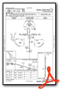
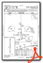
Instrument Approach Procedure (IAP) Charts
Nearby Airports with Instrument Procedures
| ID | Name | Heading / Distance | ||
|---|---|---|---|---|
 |
KHHW | Stan Stamper Municipal Airport | 150° | 11.0 |
|
KPRX | Cox Field Airport | 163° | 34.8 |
|
KDUA | Durant Regional/Eaker Field Airport | 247° | 40.1 |
|
KMLC | Mc Alester Regional Airport | 350° | 41.8 |
|
4O4 | Mc Curtain County Regional Airport | 113° | 42.9 |
|
F00 | Jones Field Airport | 217° | 43.7 |
|
2F7 | Commerce Municipal Airport | 192° | 55.3 |
|
1F4 | Madill Municipal Airport | 267° | 57.9 |
|
KSWI | Sherman Municipal Airport | 234° | 57.9 |
|
KGYI | North Texas Regional/Perrin Field Airport | 240° | 58.6 |
|
KSLR | Sulphur Springs Municipal Airport | 178° | 61.9 |
|
F53 | Franklin County Airport | 160° | 62.1 |
Airport Images
Do you have a recent image of this airport? Upload it here!


