Login
Register


1MN6
Cook Hospital Heliport
Official FAA Data Effective 2026-01-22 0901Z
VFR Chart of 1MN6
Sectional Charts at SkyVector.com
IFR Chart of 1MN6
Enroute Charts at SkyVector.com
Location Information for 1MN6
Coordinates: N47°51.16' / W92°40.74'Located 00 miles E of Cook, Minnesota. View all Airports in Minnesota.
Estimated Elevation is 1315 feet MSL.
Operations Data
|
|
Airport Communications
| UNICOM: | 123.050 |
|---|---|
| AWOS-3 at CQM (1.9 S): | 118.175 218-666-2539 |
| AWOS-3PT at ORB (12.1 NW): | 118.325 218-757-3169 |
| AWOS-3 at CDD (26.1 N): | 118.2 218-993-2467 |
Nearby Navigation Aids
|
| ||||||||||||||||||||||||||||||||||||||||||


Helipad H1
| Dimensions: | 50 x 50 feet / 15 x 15 meters | |
|---|---|---|
| Surface: | Concrete | |
| Edge Lighting: | Perimeter | |
| Coordinates: | N47°51.16' / W92°40.74' | N0°0.00' / E0°0.00' |
| Elevation: | 1315.0 | |
Ownership Information
| Ownership: | Privately Owned | |
|---|---|---|
| Owner: | COOK ORR HEALTH CARE DISTRICT | |
| 10 SE 5TH STREET | ||
| COOK, MN 55723 | ||
| 218-666-5945 | ||
| Manager: | TERESA DEBEVEC | |
| 10 SE 5TH STREET | ||
| COOK, MN 55723 | ||
| 218-666-5945 | ||
Other Remarks
- FOR CD CTC MINNEAPOLIS ARTCC AT 651-463-5588.
- ACTVT PERIMETER LGTS - 123.05.
Nearby Airports with Instrument Procedures
| ID | Name | Heading / Distance | ||
|---|---|---|---|---|
 |
KCQM | Cook Municipal Airport | 193° | 1.9 |
|
KORB | Orr Regional Airport | 323° | 12.1 |
|
12D | Tower Municipal Airport | 097° | 16.0 |
|
KEVM | Eveleth/Virginia Municipal Airport | 163° | 26.8 |
|
KHIB | Range Regional Airport | 193° | 28.7 |
|
KELO | Ely Municipal Airport | 092° | 34.4 |
|
KFOZ | Bigfork Municipal Airport | 264° | 39.5 |
|
KGPZ | Grand Rapids/Itasca County-Gordon Newstrom Field Airport | 221° | 51.3 |
|
KINL | Falls International/Einarson Field Airport | 326° | 51.7 |
|
KTWM | Richard B Helgeson Airport | 141° | 61.4 |
|
KDLH | Duluth International Airport | 161° | 63.8 |
|
KCOQ | Cloquet/Carlton County Airport | 174° | 69.5 |
Airport Images
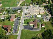
By: BobbyV


